TopoQuest Logo
Do you find TopoQuest useful?
Help keep TopoQuest running and adding new maps/features by donating!
Bitcoin:  19c7KJd3qBynnjoSw5npx9KScwjBe4ifkT
Litecoin:  LXs6TkuXGGXo1vDsWCkWVdjQX94eUKd6ui
Home View Maps Find Maps Find Places Resources & Links


Keams Canyon, Arizona Topographic Map

USGS Map Title: Keams Canyon, AZ
USGS Map MRC: 35110G2
DRG (GeoTIFF) Download: o35110g2.tif


Neighboring USGS Topographic Map Quads:


  Wepo Village, AZ  
35110H3
 

  Echo Canyon, AZ  
35110H2
 

  Low Mountain, AZ  
35110H1
 

  Sun Altar, AZ  
35110G3
 

  Keams Canyon, AZ  
35110G2
 

  Lamb Well, AZ  
35110G1
 

  Star Mountain, AZ  
35110F3
 

  Jeddito Spring, AZ  
35110F2
 

  Tsin Naan Tee, AZ  
35110F1


Map MRC Location:

N36°
W111°
N36°
W110°
H8 H7 H6 H5 H4 H3 H2 H1
G8 G7 G6 G5 G4 G3 G2 G1
F8 F7 F6 F5 F4 F3 F2 F1
E8 E7 E6 E5 E4 E3 E2 E1
D8 D7 D6 D5 D4 D3 D2 D1
C8 C7 C6 C5 C4 C3 C2 C1
B8 B7 B6 B5 B4 B3 B2 B1
A8 A7 A6 A5 A4 A3 A2 A1
N35°
W111°
N35°
W110°

Keams Canyon, AZ USGS 1:24K Topographic Map Preview:
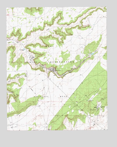
Keams Canyon, AZ USGS Topographic Map
Click on map above to begin viewing in our Map Viewer.

This topographic map contains these locations and features:
Feature Name Type Latitude Longitude GNIS ID View Map
Antelope MesaSummitN35.7728°W110.2090°42853View Map
Bluebird SpringSpringN35.7892°W110.2424°1753View Map
ChakpahuPopulated PlaceN35.7620°W110.1729°24355View Map
Chili SpringSpringN35.8042°W110.1893°2836View Map
Department of Health Indian HospitalHospitalN35.8131°W110.1923°23351View Map
Dove SpringSpringN35.7811°W110.1329°4078View Map
JedditoPopulated PlaceN35.7745°W110.1368°24262View Map
Jeddito Census Designated PlaceCensusN35.7697°W110.1305°2408440View Map
Jeddito SchoolSchoolN35.7727°W110.1383°2426225View Map
Keams CanyonPopulated PlaceN35.8125°W110.1951°6629View Map
Keams Canyon Boarding SchoolSchoolN35.8105°W110.1916°23391View Map
Keams Canyon CampgroundLocaleN35.8156°W110.2093°23392View Map
Keams Canyon Census Designated PlaceCensusN35.8229°W110.2011°2408463View Map
Keams Canyon Community ParkParkN35.8133°W110.2051°23393View Map
Keams Canyon Day SchoolSchoolN35.8097°W110.1899°23394View Map
Keams Canyon Fire DepartmentBuildingN35.8115°W110.1967°2672352View Map
Keams Canyon Post OfficePost OfficeN35.8114°W110.1970°44965View Map
Kit Carson InscriptionLocaleN35.8122°W110.1696°6723View Map
KokopnyamaPopulated PlaceN35.7803°W110.1254°24483View Map
Lake MahoLakeN35.8103°W110.1701°7594View Map
NesuftangaPopulated PlaceN35.7803°W110.1412°24533View Map
Pink ArrowPopulated PlaceN35.7770°W110.1573°24562View Map
Skunk SpringsSpringN35.7508°W110.2004°11412View Map
Snowbird SpringSpringN35.8049°W110.2254°11504View Map
Twin DamsDamN35.8261°W110.1448°12941View Map

Note: Coordinates in the location and feature list above are referenced to NAD83 datum.


Copyright (C) 2008-2025 Ryan Niemi / Sunset Dynamics ... All Rights Reserved