TopoQuest Logo
Do you find TopoQuest useful?
Help keep TopoQuest running and adding new maps/features by donating!
Bitcoin:  19c7KJd3qBynnjoSw5npx9KScwjBe4ifkT
Litecoin:  LXs6TkuXGGXo1vDsWCkWVdjQX94eUKd6ui
Home View Maps Find Maps Find Places Resources & Links


Rudd Knoll, Arizona Topographic Map

USGS Map Title: Rudd Knoll, AZ
USGS Map MRC: 33109H3
DRG (GeoTIFF) Download: o33109h3.tif


Neighboring USGS Topographic Map Quads:


  Greer, AZ  
34109A4
 

  Eagar, AZ  
34109A3
 

  Nelson Reservoir, AZ  
34109A2
 

  Big Lake North, AZ  
33109H4
 

  Rudd Knoll, AZ  
33109H3
 

  Nutrioso, AZ  
33109H2
 

  Big Lake South, AZ  
33109G4
 

  Buffalo Crossing, AZ  
33109G3
 

  Alpine, AZ  
33109G2


Map MRC Location:

N34°
W110°
N34°
W109°
H8 H7 H6 H5 H4 H3 H2 H1
G8 G7 G6 G5 G4 G3 G2 G1
F8 F7 F6 F5 F4 F3 F2 F1
E8 E7 E6 E5 E4 E3 E2 E1
D8 D7 D6 D5 D4 D3 D2 D1
C8 C7 C6 C5 C4 C3 C2 C1
B8 B7 B6 B5 B4 B3 B2 B1
A8 A7 A6 A5 A4 A3 A2 A1
N33°
W110°
N33°
W109°

Rudd Knoll, AZ USGS 1:24K Topographic Map Preview:
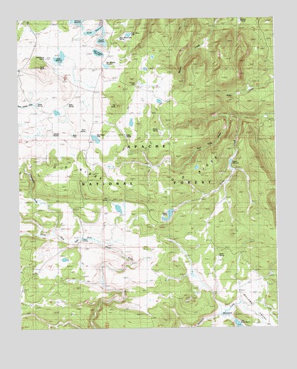
Rudd Knoll, AZ USGS Topographic Map
Click on map above to begin viewing in our Map Viewer.

This topographic map contains these locations and features:
Feature Name Type Latitude Longitude GNIS ID View Map
Arrow TankReservoirN33.9832°W109.3705°41448View Map
Atcheson ReservoirReservoirN33.9996°W109.3456°25837View Map
Bluff TankReservoirN33.9912°W109.3483°1853568View Map
Bog TankReservoirN33.9770°W109.3573°1853566View Map
BoneyardPopulated PlaceN33.8792°W109.2723°39009View Map
Boneyard SpringSpringN33.8923°W109.2692°41417View Map
Bottom SpringSpringN33.9256°W109.3643°41444View Map
Burk SpringSpringN33.9553°W109.3420°27014View Map
Burk TankReservoirN33.9531°W109.3490°44771View Map
Burky TankReservoirN33.9490°W109.3592°41446View Map
Burn Meadow TankSwampN33.9397°W109.2887°1853571View Map
Chambers DrawArroyoN33.9135°W109.3587°39021View Map
Conklin SpringSpringN33.8934°W109.3529°41441View Map
Crosby CrossingPopulated PlaceN33.9117°W109.3451°28182View Map
Crosby SpringSpringN33.9120°W109.3440°1853559View Map
East Fork Black River SpringSpringN33.9092°W109.3462°1853569View Map
East Fork Number Three SpringSpringN33.9117°W109.3098°41422View Map
East Fork Spring Number OneSpringN33.9106°W109.3309°41420View Map
East Fork Spring Number SixSpringN33.8837°W109.3179°41416View Map
East Fork Spring Number TwoSpringN33.9106°W109.3279°41421View Map
East Fork Springs Number FiveSpringN33.8842°W109.3142°41414View Map
East Fork Springs Number FourSpringN33.8937°W109.3137°41412View Map
Flat TankReservoirN33.9865°W109.3737°41453View Map
Fly SpringSpringN33.9084°W109.3662°1853548View Map
Hill TankReservoirN33.9792°W109.3554°41449View Map
Hillside SpringSpringN33.9534°W109.3579°29989View Map
Jessie SpringSpringN33.9528°W109.3230°30529View Map
Jessie Spring MarshSwampN33.9537°W109.3176°41426View Map
Lost SpringSpringN33.9892°W109.3436°1853664View Map
Milkpen SpringSpringN33.9456°W109.3643°1853570View Map
Milkpen TankReservoirN33.9456°W109.3643°41447View Map
Miller SpringSpringN33.9823°W109.3466°41430View Map
Miller SpringSpringN33.9656°W109.3501°31876View Map
Moon TankReservoirN33.9707°W109.3718°41450View Map
North SpringSpringN33.9031°W109.2787°32396View Map
Number Four TankReservoirN33.9940°W109.3708°41452View Map
O D RidgeRidgeN33.9389°W109.3340°32414View Map
O D SpringSpringN33.9270°W109.3320°45017View Map
OD SpringSpringN33.9270°W109.3320°41443View Map
Pat KnollSummitN33.9648°W109.3268°32716View Map
Pat KnollSummitN33.9756°W109.3206°41432View Map
Pat Knoll Guard StationLocaleN33.9734°W109.3176°32717View Map
Pat Knoll LakeSwampN33.9667°W109.3065°1853572View Map
Pat Knoll Pit SpringsSpringN33.9738°W109.3161°41433View Map
Pat Knoll TankReservoirN33.9646°W109.3137°41425View Map
Pat SinkBasinN33.9581°W109.3198°41424View Map
Pin TankReservoirN33.9041°W109.3659°41439View Map
Red Hole DrawValleyN33.9600°W109.2734°45018View Map
Road TankReservoirN33.9712°W109.3331°41434View Map
Rogers DamDamN33.9434°W109.2706°39125View Map
Rogers MarshLakeN33.9191°W109.3030°44772View Map
Rogers ReservoirReservoirN33.9434°W109.2706°39126View Map
Rosebud CienegaSwampN33.9991°W109.2670°44773View Map
Rudd Knoll Pit Number ThreeBasinN33.9887°W109.3545°41438View Map
Rudd Knoll Pit Tank Number 1ReservoirN33.9734°W109.3405°41431View Map
Rudd Knoll Pit Tank Number 114ReservoirN33.9952°W109.3542°41437View Map
Rudd Knoll SpringSpringN33.9800°W109.3643°33860View Map
Rudd Knoll SpringSpringN33.9846°W109.3616°33861View Map
Rudd ReservoirReservoirN33.9840°W109.3548°33862View Map
Russell ReservoirReservoirN33.9912°W109.3337°39127View Map
Saint Josephs ReservoirReservoirN33.9865°W109.3357°39128View Map
Saint Marys DamDamN33.9934°W109.3218°39129View Map
Saint Marys LakeLakeN33.9937°W109.3211°33961View Map
Saint Marys Lake SpringSpringN33.9923°W109.3255°31554View Map
Saint Marys TankReservoirN33.9847°W109.3094°44737View Map
Salt House TankReservoirN33.9404°W109.3291°41427View Map
Salt House TankLakeN33.9517°W109.3375°33992View Map
San Salvador DamDamN33.9817°W109.3290°39131View Map
San Salvador ReservoirReservoirN33.9817°W109.3290°39132View Map
Section Twenty-Three TankReservoirN33.8997°W109.3671°41440View Map
Seven SpringsSpringN33.9642°W109.3654°34278View Map
Sickel TankReservoirN33.9656°W109.3405°41435View Map
Sierra Blanca DamDamN33.8751°W109.2706°39145View Map
Slade ReservoirReservoirN33.9957°W109.3365°34516View Map
Stit SpringSpringN33.8853°W109.3718°41436View Map
Stump SpringSpringN33.9550°W109.3076°34909View Map
Timber SpringSpringN33.9076°W109.3559°1853560View Map
Tom Thumb SpringSpringN33.9498°W109.3659°1853565View Map
Turkey TankReservoirN33.9003°W109.3451°41423View Map
Udall Hole TankReservoirN33.9394°W109.3644°41442View Map
Udall PitBasinN33.8839°W109.3106°41415View Map
Udall Pit Number FiveSpringN33.8923°W109.3167°41413View Map
Udall Pit Number One TankReservoirN33.9261°W109.3309°41428View Map
Udall Pit Number ThreeMineN33.9176°W109.3134°41419View Map
Udall Pit Number TwoReservoirN33.9235°W109.3270°41418View Map
Udall Pit Number Two TankReservoirN33.9254°W109.3296°41429View Map
Udall Pit Tank Number 4ReservoirN33.9106°W109.3034°1853550View Map
Udall Pit Tank Number 6ReservoirN33.8840°W109.3107°1853549View Map
Upper SpringSpringN33.9687°W109.3601°41445View Map

Note: Coordinates in the location and feature list above are referenced to NAD83 datum.


Copyright (C) 2008-2025 Ryan Niemi / Sunset Dynamics ... All Rights Reserved