TopoQuest Logo
Do you find TopoQuest useful?
Help keep TopoQuest running and adding new maps/features by donating!
Bitcoin:  19c7KJd3qBynnjoSw5npx9KScwjBe4ifkT
Litecoin:  LXs6TkuXGGXo1vDsWCkWVdjQX94eUKd6ui
Home View Maps Find Maps Find Places Resources & Links


Saint John Ponds, Maine Topographic Map

USGS Map Title: Saint John Ponds, ME
USGS Map MRC: 46069A8
DRG (GeoTIFF) Download: o46069a8.tif


Neighboring USGS Topographic Map Quads:


  Hinckley Hill, ME  
46070B1
 

  Saint John Pond Depot, ME  
46069B8
 

  Spruce Brook, ME  
46069B7
 

  Norris Brook, ME  
46070A1
 

  Saint John Ponds, ME  
46069A8
 

  Russell Mountain, ME  
46069A7
 

  Foley Pond, ME  
45070H1
 

  Seboomook Lake West, ME  
45069H8
 

  Seboomook Lake East, ME  
45069H7


Map MRC Location:

N47°
W70°
N47°
W69°
H8 H7 H6 H5 H4 H3 H2 H1
G8 G7 G6 G5 G4 G3 G2 G1
F8 F7 F6 F5 F4 F3 F2 F1
E8 E7 E6 E5 E4 E3 E2 E1
D8 D7 D6 D5 D4 D3 D2 D1
C8 C7 C6 C5 C4 C3 C2 C1
B8 B7 B6 B5 B4 B3 B2 B1
A8 A7 A6 A5 A4 A3 A2 A1
N46°
W70°
N46°
W69°

Saint John Ponds, ME USGS 1:24K Topographic Map Preview:
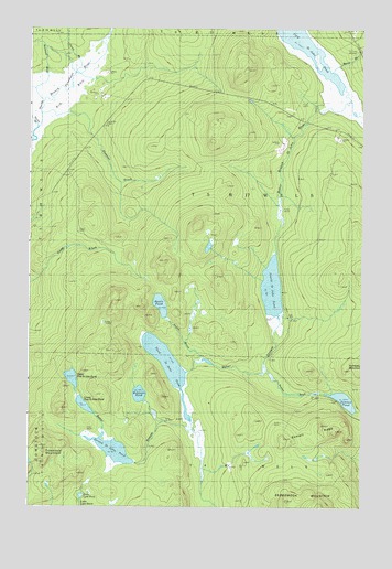
Saint John Ponds, ME USGS Topographic Map
Click on map above to begin viewing in our Map Viewer.

This topographic map contains these locations and features:
Feature Name Type Latitude Longitude GNIS ID View Map
Austin BrookStreamN46.0389°W69.9342°561360View Map
Austin PondLakeN46.0528°W69.9504°561362View Map
Baker StreamStreamN46.0500°W69.9065°561488View Map
Beaver BrookStreamN46.1153°W69.8840°561915View Map
Fourth Saint John PondLakeN46.0572°W69.9086°566493View Map
Little Lane PondLakeN46.0027°W69.9797°569871View Map
Lower First Saint John PondLakeN46.0265°W69.9790°570500View Map
McDonald BrookStreamN46.1134°W69.9931°570969View Map
Prouty BrookStreamN46.1175°W69.9823°573845View Map
Robinson PondLakeN46.0294°W69.9581°574331View Map
Second Saint John PondReservoirN46.0147°W69.9676°575210View Map
Sheehan BrookStreamN46.1031°W69.9853°575335View Map
Summit BrookStreamN46.0367°W69.9112°576516View Map
Summit PondLakeN46.0280°W69.8812°576519View Map
Summit RidgeRidgeN46.0198°W69.8959°576520View Map
T5 R17 WELSCivilN46.0863°W69.9219°1987449View Map
Third Saint John PondLakeN46.0375°W69.9479°576968View Map
Truesdale MountainSummitN46.0158°W69.9954°577368View Map
Unorganized Territory of Seboomook LakeCivilN46.0978°W69.9887°582720View Map
Upper First Saint John PondLakeN46.0335°W69.9836°577606View Map

Note: Coordinates in the location and feature list above are referenced to NAD83 datum.


Copyright (C) 2008-2025 Ryan Niemi / Sunset Dynamics ... All Rights Reserved