TopoQuest Logo
Do you find TopoQuest useful?
Help keep TopoQuest running and adding new maps/features by donating!
Bitcoin:  19c7KJd3qBynnjoSw5npx9KScwjBe4ifkT
Litecoin:  LXs6TkuXGGXo1vDsWCkWVdjQX94eUKd6ui
Home View Maps Find Maps Find Places Resources & Links


Sing Peak, California Topographic Map

USGS Map Title: Sing Peak, CA
USGS Map MRC: 37119E4
DRG (GeoTIFF) Download: o37119e4.tif


Neighboring USGS Topographic Map Quads:


  Half Dome, CA  
37119F5
 

  Merced Peak, CA  
37119F4
 

  Mount Lyell, CA  
37119F3
 

  Mariposa Grove, CA  
37119E5
 

  Sing Peak, CA  
37119E4
 

  Timber Knob, CA  
37119E3
 

  White Chief Mountain, CA  
37119D5
 

  Little Shuteye Peak, CA  
37119D4
 

  Squaw Dome, CA  
37119D3


Map MRC Location:

N38°
W120°
N38°
W119°
H8 H7 H6 H5 H4 H3 H2 H1
G8 G7 G6 G5 G4 G3 G2 G1
F8 F7 F6 F5 F4 F3 F2 F1
E8 E7 E6 E5 E4 E3 E2 E1
D8 D7 D6 D5 D4 D3 D2 D1
C8 C7 C6 C5 C4 C3 C2 C1
B8 B7 B6 B5 B4 B3 B2 B1
A8 A7 A6 A5 A4 A3 A2 A1
N37°
W120°
N37°
W119°

Sing Peak, CA USGS 1:24K Topographic Map Preview:
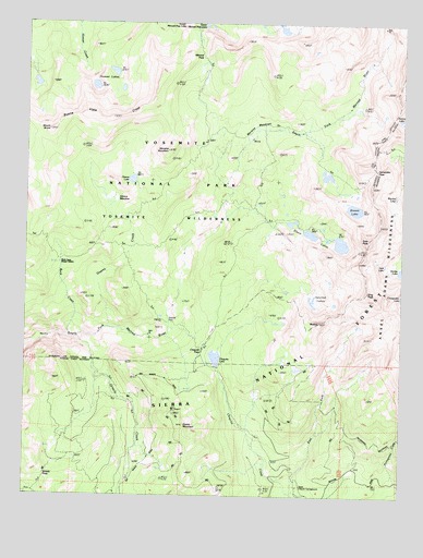
Sing Peak, CA USGS Topographic Map
Click on map above to begin viewing in our Map Viewer.

This topographic map contains these locations and features:
Feature Name Type Latitude Longitude GNIS ID View Map
Alpine LakeLakeN37.5998°W119.3769°253413View Map
Blackie LakeLakeN37.5794°W119.3783°219421View Map
Breeze LakeLakeN37.5760°W119.3918°254661View Map
Brophy MeadowFlatN37.5241°W119.4224°275715View Map
Buck Camp Ranger StationLocaleN37.5630°W119.4896°253064View Map
Buck CreekStreamN37.5422°W119.4868°254667View Map
Buena Vista CrestRidgeN37.6109°W119.4568°254674View Map
Chain LakesLakeN37.5693°W119.4064°254736View Map
Chiquito LakeLakeN37.5358°W119.4375°253440View Map
Chiquito PassGapN37.5416°W119.4396°254742View Map
Chittenden LakeLakeN37.5539°W119.3752°253442View Map
Cold Springs MeadowFlatN37.5130°W119.4913°253446View Map
East Fork Chiquito CreekStreamN37.5002°W119.4112°253458View Map
Fernandez PassGapN37.5863°W119.3854°233872View Map
Gale LakeLakeN37.5609°W119.3816°253473View Map
Gale PeakSummitN37.5680°W119.3871°224008View Map
Givens CreekStreamN37.5444°W119.4735°253476View Map
Givens LakeLakeN37.5835°W119.4658°252268View Map
Givens MeadowFlatN37.5788°W119.4754°224191View Map
Gravelly FordLocaleN37.5466°W119.4532°224490View Map
Grizzly CreekStreamN37.5419°W119.4832°253491View Map
Grizzly PassGapN37.5055°W119.4932°252497View Map
Hoover LakesLakeN37.6082°W119.4784°253513View Map
Klette MeadowFlatN37.5322°W119.4129°275714View Map
Merced PassGapN37.6160°W119.4435°228514View Map
Moraine MeadowsFlatN37.5974°W119.4235°254949View Map
Moraine MountainSummitN37.5914°W119.4538°254950View Map
Mount BruceSummitN37.5962°W119.4935°252498View Map
Mud LakesLakeN37.5458°W119.4175°275712View Map
Quartz MountainSummitN37.5185°W119.4479°231126View Map
RedtopSummitN37.5459°W119.4030°255027View Map
Shirley LakeLakeN37.5597°W119.3764°253580View Map
Sing PeakSummitN37.5539°W119.3875°253858View Map
Spotted LakesLakeN37.5515°W119.4056°253922View Map
Swamp LakeLakeN37.5472°W119.4560°235871View Map
Upper Chiquito CampgroundLocaleN37.5022°W119.4107°253623View Map
Upper Merced Pass LakeLakeN37.6244°W119.4421°236905View Map
Walker MineMineN37.5147°W119.3937°275716View Map

Note: Coordinates in the location and feature list above are referenced to NAD83 datum.


Copyright (C) 2008-2024 Ryan Niemi / Sunset Dynamics ... All Rights Reserved