TopoQuest Logo
Do you find TopoQuest useful?
Help keep TopoQuest running and adding new maps/features by donating!
Bitcoin:  19c7KJd3qBynnjoSw5npx9KScwjBe4ifkT
Litecoin:  LXs6TkuXGGXo1vDsWCkWVdjQX94eUKd6ui
Home View Maps Find Maps Find Places Resources & Links


Ten Lakes, California Topographic Map

USGS Map Title: Ten Lakes, CA
USGS Map MRC: 37119H5
DRG (GeoTIFF) Download: o37119h5.tif


Neighboring USGS Topographic Map Quads:


  Tiltill Mountain, CA  
38119A6
 

  Piute Mountain, CA  
38119A5
 

  Matterhorn Peak, CA  
38119A4
 

  Hetch Hetchy Reservoir, CA  
37119H6
 

  Ten Lakes, CA  
37119H5
 

  Falls Ridge, CA  
37119H4
 

  Tamarack Flat, CA  
37119G6
 

  Yosemite Falls, CA  
37119G5
 

  Tenaya Lake, CA  
37119G4


Map MRC Location:

N38°
W120°
N38°
W119°
H8 H7 H6 H5 H4 H3 H2 H1
G8 G7 G6 G5 G4 G3 G2 G1
F8 F7 F6 F5 F4 F3 F2 F1
E8 E7 E6 E5 E4 E3 E2 E1
D8 D7 D6 D5 D4 D3 D2 D1
C8 C7 C6 C5 C4 C3 C2 C1
B8 B7 B6 B5 B4 B3 B2 B1
A8 A7 A6 A5 A4 A3 A2 A1
N37°
W120°
N37°
W119°

Ten Lakes, CA USGS 1:24K Topographic Map Preview:
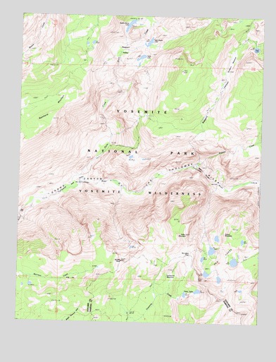
Ten Lakes, CA USGS Topographic Map
Click on map above to begin viewing in our Map Viewer.

This topographic map contains these locations and features:
Feature Name Type Latitude Longitude GNIS ID View Map
Cathedral CreekStreamN37.9316°W119.5013°253433View Map
Colby MountainSummitN37.9112°W119.5394°254757View Map
Double RockSummitN37.8996°W119.5726°253688View Map
Grand MountainSummitN37.9116°W119.5190°253483View Map
Grant LakesLakeN37.8866°W119.5392°253485View Map
Halfmoon MeadowFlatN37.8946°W119.5460°224794View Map
Irwin Bright LakeLakeN37.9892°W119.5599°254821View Map
Muir GorgeValleyN37.9398°W119.5346°254959View Map
Neall LakeLakeN37.9872°W119.5045°254966View Map
Pate ValleyBasinN37.9333°W119.5968°253742View Map
Piute CreekStreamN37.9299°W119.6007°253760View Map
Pleasant ValleyBasinN37.9833°W119.5718°1654905View Map
Rancheria MountainSummitN37.9696°W119.6007°255017View Map
Register CreekStreamN37.9396°W119.5349°255029View Map
Rodgers CanyonValleyN37.9400°W119.5345°255047View Map
Rodgers MeadowFlatN37.9916°W119.5093°255049View Map
Saddle Horse LakeLakeN37.9962°W119.5701°253809View Map
Table LakeLakeN37.9836°W119.5628°253957View Map
Ten LakesLakeN37.8999°W119.5204°255122View Map
Ten Lakes PassGapN37.9027°W119.5368°252228View Map
Ten Lakes TrailTrailN37.8883°W119.5557°253615View Map

Note: Coordinates in the location and feature list above are referenced to NAD83 datum.


Copyright (C) 2008-2024 Ryan Niemi / Sunset Dynamics ... All Rights Reserved