TopoQuest Logo
Do you find TopoQuest useful?
Help keep TopoQuest running and adding new maps/features by donating!
Bitcoin:  19c7KJd3qBynnjoSw5npx9KScwjBe4ifkT
Litecoin:  LXs6TkuXGGXo1vDsWCkWVdjQX94eUKd6ui
Home View Maps Find Maps Find Places Resources & Links


Twin Bridges, Montana Topographic Map

USGS Map Title: Twin Bridges, MT
USGS Map MRC: 45112E3
DRG (GeoTIFF) Download: o45112e3.tif


Neighboring USGS Topographic Map Quads:


  Table Mountain, MT  
45112F4
 

  Silver Star, MT  
45112F3
 

  Waterloo, MT  
45112F2
 

  Twin Bridges SW, MT  
45112E4
 

  Twin Bridges, MT  
45112E3
 

  Old Baldy Mountain, MT  
45112E2
 

  Beaverhead Rock, MT  
45112D4
 

  Beaverhead Rock NE, MT  
45112D3
 

  Sheridan, MT  
45112D2


Map MRC Location:

N46°
W113°
N46°
W112°
H8 H7 H6 H5 H4 H3 H2 H1
G8 G7 G6 G5 G4 G3 G2 G1
F8 F7 F6 F5 F4 F3 F2 F1
E8 E7 E6 E5 E4 E3 E2 E1
D8 D7 D6 D5 D4 D3 D2 D1
C8 C7 C6 C5 C4 C3 C2 C1
B8 B7 B6 B5 B4 B3 B2 B1
A8 A7 A6 A5 A4 A3 A2 A1
N45°
W113°
N45°
W112°

Twin Bridges, MT USGS 1:24K Topographic Map Preview:
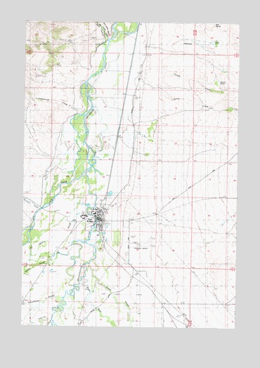
Twin Bridges, MT USGS Topographic Map
Click on map above to begin viewing in our Map Viewer.

This topographic map contains these locations and features:
Feature Name Type Latitude Longitude GNIS ID View Map
02S06W35DCB_01 WellWellN45.6146°W112.3058°810550View Map
03S05W18DBCA01 WellWellN45.5733°W112.2653°810216View Map
03S06W11BAAA01 WellWellN45.5971°W112.3092°810388View Map
03S06W35BDAB01 WellWellN45.5346°W112.3100°810012View Map
Bayers DitchCanalN45.5738°W112.3128°779456View Map
Beaverhead RiverStreamN45.5677°W112.3386°779637View Map
Big Hole RiverStreamN45.5677°W112.3392°779824View Map
California SloughStreamN45.5060°W112.3550°780786View Map
Church of ChristChurchN45.5452°W112.3306°793759View Map
Church of the ValleyChurchN45.5416°W112.3306°793761View Map
Cottonwood CreekStreamN45.5871°W112.3425°781730View Map
Currant CreekStreamN45.6044°W112.3075°781999View Map
Dry Georgia GulchValleyN45.5194°W112.3008°782610View Map
Dry GulchValleyN45.5874°W112.2506°782627View Map
Eastman DitchCanalN45.5041°W112.3500°782965View Map
Gaffney (historical)LocaleN45.5202°W112.3119°1797521View Map
Goodrich GulchValleyN45.5358°W112.2847°784096View Map
Hankins SpringSpringN45.6007°W112.2628°784519View Map
Hells Canyon CreekStreamN45.6174°W112.3275°784746View Map
High Road Fishing Access SiteLocaleN45.5474°W112.3683°1744508View Map
Hope Methodist Church (historical)ChurchN45.5444°W112.3311°1797449View Map
Jacobs SloughStreamN45.5258°W112.3364°785404View Map
Jefferson Valley Historical MarkerParkN45.6210°W112.3106°1797797View Map
Jessen Park Tourist AreaLocaleN45.5444°W112.3311°1797443View Map
Kingdom Hall of Jehova's WitnessesChurchN45.5471°W112.3306°793796View Map
Lewis-Jenkins DitchCanalN45.5058°W112.2953°778814View Map
Madison County FairgroundsLocaleN45.5416°W112.3356°1797442View Map
Masonic CemeteryCemeteryN45.5427°W112.3130°1797434View Map
McCammeron (historical)LocaleN45.5099°W112.3281°1797486View Map
Montana Childrens Center (historical)SchoolN45.5444°W112.3311°1797427View Map
Mountain View Southern Baptist ChapelChurchN45.5444°W112.3311°1797448View Map
Notre Dame Catholic ChurchChurchN45.5460°W112.3306°793809View Map
Owsley SloughStreamN45.5341°W112.3458°806798View Map
Pogliano RanchLocaleN45.6060°W112.2608°789016View Map
Presbyterian Church of Twin Bridges (historical)ChurchN45.5444°W112.3311°1797447View Map
Rochester CreekStreamN45.5477°W112.3658°789655View Map
Ruby RiverStreamN45.5202°W112.3402°789840View Map
Sage (historical)LocaleN45.6208°W112.3106°1797631View Map
Salisbury Post Office (historical)Post OfficeN45.5202°W112.3119°1797571View Map
Schoolhouse SloughStreamN45.5116°W112.3514°790131View Map
Seidensticker RanchLocaleN45.5549°W112.3633°794343View Map
Seyler-Tash DitchCanalN45.5041°W112.3000°778832View Map
Spring CreekStreamN45.5005°W112.3592°791273View Map
Spring CreekStreamN45.6219°W112.3106°791260View Map
Stardust Country Inn and RV ParkLocaleN45.5438°W112.3314°1797665View Map
Tash Drain DitchCanalN45.5216°W112.3253°791899View Map
Third SloughStreamN45.5574°W112.3375°792066View Map
Town of Twin BridgesCivilN45.5429°W112.3341°2413407View Map
Twin BridgesLocaleN45.5444°W112.3281°1797653View Map
Twin BridgesPopulated PlaceN45.5444°W112.3311°792499View Map
Twin Bridges AirportAirportN45.5342°W112.3014°806543View Map
Twin Bridges CemeteryCemeteryN45.5305°W112.3147°1797435View Map
Twin Bridges City Fire DepartmentBuildingN45.5457°W112.3305°2546647View Map
Twin Bridges City ParkParkN45.5444°W112.3311°1797444View Map
Twin Bridges City Park Rest AreaLocaleN45.5444°W112.3311°1797798View Map
Twin Bridges DivisionCivilN45.6052°W112.3592°1940732View Map
Twin Bridges Post OfficePost OfficeN45.5440°W112.3307°1797654View Map
Twin Bridges Public LibraryBuildingN45.5444°W112.3311°1797553View Map
Twin Bridges SchoolSchoolN45.5462°W112.3333°1797428View Map

Note: Coordinates in the location and feature list above are referenced to NAD83 datum.


Copyright (C) 2008-2024 Ryan Niemi / Sunset Dynamics ... All Rights Reserved