TopoQuest Logo
Do you find TopoQuest useful?
Help keep TopoQuest running and adding new maps/features by donating!
Bitcoin:  19c7KJd3qBynnjoSw5npx9KScwjBe4ifkT
Litecoin:  LXs6TkuXGGXo1vDsWCkWVdjQX94eUKd6ui
Home View Maps Find Maps Find Places Resources & Links


Casa Grande Mountains, Arizona Topographic Map

USGS Map Title: Casa Grande Mountains, AZ
USGS Map MRC: 32111G6
DRG (GeoTIFF) Download: o32111g6.tif


Neighboring USGS Topographic Map Quads:


  Casa Grande West, AZ  
32111H7
 

  Casa Grande East, AZ  
32111H6
 

  Coolidge, AZ  
32111H5
 

  Chuichu, AZ  
32111G7
 

  Casa Grande Mountains, AZ  
32111G6
 

  Eloy North, AZ  
32111G5
 

  Silver Reef Mountains, AZ  
32111F7
 

  Arizona City, AZ  
32111F6
 

  Eloy South, AZ  
32111F5


Map MRC Location:

N33°
W112°
N33°
W111°
H8 H7 H6 H5 H4 H3 H2 H1
G8 G7 G6 G5 G4 G3 G2 G1
F8 F7 F6 F5 F4 F3 F2 F1
E8 E7 E6 E5 E4 E3 E2 E1
D8 D7 D6 D5 D4 D3 D2 D1
C8 C7 C6 C5 C4 C3 C2 C1
B8 B7 B6 B5 B4 B3 B2 B1
A8 A7 A6 A5 A4 A3 A2 A1
N32°
W112°
N32°
W111°

Casa Grande Mountains, AZ USGS 1:24K Topographic Map Preview:
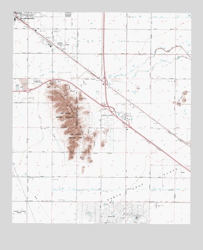
Casa Grande Mountains, AZ USGS Topographic Map
Click on map above to begin viewing in our Map Viewer.

This topographic map contains these locations and features:
Feature Name Type Latitude Longitude GNIS ID View Map
American Boy MineMineN32.8306°W111.6260°23645View Map
ArizolaPopulated PlaceN32.8512°W111.7143°765View Map
Arizola InterchangeCrossingN32.8198°W111.6832°23647View Map
Arizona CityPopulated PlaceN32.7559°W111.6710°770View Map
Arizona City Census Designated PlaceCensusN32.7506°W111.6707°2407758View Map
Arizona City Fire DistrictBuildingN32.7526°W111.6718°2672444View Map
Arizona City Post OfficePost OfficeN32.7625°W111.6815°2670262View Map
Arizona City Sanitary District Wastewater Treatment PlantLocaleN32.7620°W111.6867°2669603View Map
Campground Buena TierraLocaleN32.8263°W111.6916°2669717View Map
Casa Grande Country ClubLocaleN32.8362°W111.7110°43166View Map
Casa Grande East Mobile Home ParkPopulated PlaceN32.8742°W111.7434°2669752View Map
Casa Grande InterchangeCrossingN32.8334°W111.6857°23669View Map
Casa Grande Military ReservoirReservoirN32.8164°W111.7151°2504View Map
Casa Grande Mountain ParkParkN32.8323°W111.7179°2505View Map
Casa Grande MountainsRidgeN32.8139°W111.7096°2506View Map
Central Lutheran Church Arizona City SiteChurchN32.7625°W111.6708°2670706View Map
Fiesta Grande Mobile Home ParkPopulated PlaceN32.8739°W111.7201°2670389View Map
First Baptist ChurchChurchN32.7535°W111.6706°2670938View Map
Grace Lutheran ChurchChurchN32.8740°W111.7089°2671103View Map
KFAS-AM (Casa Grande)TowerN32.8637°W111.7324°45040View Map
KFAS-FM (Casa Grande)TowerN32.8242°W111.7032°45170View Map
KKAF-FM (Eloy)TowerN32.8345°W111.6382°43516View Map
KONZ-FM (Arizona City)TowerN32.8345°W111.6382°45168View Map
KPIN-AM (Casa Grande)TowerN32.8637°W111.7324°43518View Map
KSAA-FM (Casa Grande)TowerN32.8239°W111.7029°43520View Map
KSAA-FM (Casa Grande)TowerN32.8739°W111.7496°43521View Map
Mesquite Elementary SchoolSchoolN32.8742°W111.7154°2544968View Map
Mission Royale Golf ClubLocaleN32.8704°W111.6787°2669908View Map
Mosely ParkParkN32.8748°W111.7379°23754View Map
Mountain View CemeteryCemeteryN32.8338°W111.7336°8335View Map
New Hope Baptist ChurchChurchN32.8732°W111.7361°2671582View Map
Palo Verde Elementary SchoolSchoolN32.8732°W111.7415°4303View Map
Pinal County Sheriff's Office Arizona City Region BBuildingN32.7538°W111.6716°2751567View Map
Roadside Park Rest AreaParkN32.8701°W111.7449°23792View Map
Robson Ranch Golf ClubLocaleN32.8170°W111.6488°2670583View Map
Saint Anthony of Padua Catholic SchoolSchoolN32.8747°W111.7499°2545006View Map
Sunland Gin Road InterchangeCrossingN32.8092°W111.6710°23819View Map
Toltec ButtesSummitN32.8234°W111.6304°12571View Map
Toltec Elementary SchoolSchoolN32.7563°W111.6978°23828View Map
Treckell Road InterchangeCrossingN32.8284°W111.7399°23833View Map

Note: Coordinates in the location and feature list above are referenced to NAD83 datum.


Copyright (C) 2008-2024 Ryan Niemi / Sunset Dynamics ... All Rights Reserved