TopoQuest Logo
Do you find TopoQuest useful?
Help keep TopoQuest running and adding new maps/features by donating!
Bitcoin:  19c7KJd3qBynnjoSw5npx9KScwjBe4ifkT
Litecoin:  LXs6TkuXGGXo1vDsWCkWVdjQX94eUKd6ui
Home View Maps Find Maps Find Places Resources & Links


Casamero Lake, New Mexico Topographic Map

USGS Map Title: Casamero Lake, NM
USGS Map MRC: 35108E1
DRG (GeoTIFF) Download: o35108e1.tif


Neighboring USGS Topographic Map Quads:


  Crownpoint, NM  
35108F2
 

  Heart Rock, NM  
35108F1
 

  Laguna Castillo, NM  
35107F8
 

  Hosta Butte, NM  
35108E2
 

  Casamero Lake, NM  
35108E1
 

  Borrego Pass, NM  
35107E8
 

  Thoreau, NM  
35108D2
 

  Thoreau NE, NM  
35108D1
 

  Goat Mountain, NM  
35107D8


Map MRC Location:

N36°
W109°
N36°
W108°
H8 H7 H6 H5 H4 H3 H2 H1
G8 G7 G6 G5 G4 G3 G2 G1
F8 F7 F6 F5 F4 F3 F2 F1
E8 E7 E6 E5 E4 E3 E2 E1
D8 D7 D6 D5 D4 D3 D2 D1
C8 C7 C6 C5 C4 C3 C2 C1
B8 B7 B6 B5 B4 B3 B2 B1
A8 A7 A6 A5 A4 A3 A2 A1
N35°
W109°
N35°
W108°

Casamero Lake, NM USGS 1:24K Topographic Map Preview:
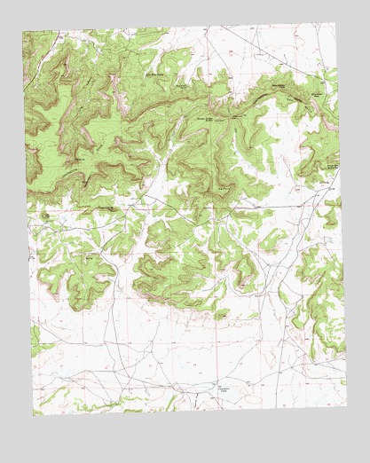
Casamero Lake, NM USGS Topographic Map
Click on map above to begin viewing in our Map Viewer.

This topographic map contains these locations and features:
Feature Name Type Latitude Longitude GNIS ID View Map
10014 Water WellWellN35.6117°W108.0215°921967View Map
10018 Water WellWellN35.5722°W108.0067°921780View Map
16B-37 Water WellWellN35.5367°W108.0345°921778View Map
16T-594 Water WellWellN35.5367°W108.1220°921779View Map
16T-597 Water WellWellN35.5292°W108.1226°921775View Map
16T588 Water WellWellN35.5061°W108.0342°921771View Map
Big PointSummitN35.5720°W108.0495°898632View Map
Blue Water SpringSpringN35.6057°W108.0606°886530View Map
Borrego Pass Trading PostLocaleN35.5778°W108.0009°886641View Map
Casamero LakeReservoirN35.5071°W108.0507°902200View Map
Casamero Lake ChapterCivilN35.5420°W108.0021°2419332View Map
Cream Colored RockSummitN35.5656°W108.0906°888060View Map
Little Water SpringSpringN35.6092°W108.0759°891195View Map
Long CanyonValleyN35.6172°W108.0942°891295View Map
Many Mexican SpringSpringN35.6047°W108.0214°891590View Map
Owl SpringSpringN35.5828°W108.1063°892983View Map
Red ButteRidgeN35.5984°W108.0153°893724View Map
Rocky PointCapeN35.5753°W108.1017°894114View Map
The CupSummitN35.5645°W108.1187°898695View Map
Tiejen ProspectMineN35.6017°W108.0423°917558View Map
Uranium DepositMineN35.5775°W108.1248°917367View Map
Wheat Grass ButteSummitN35.5934°W108.0506°933388View Map
Wheat Grass PassGapN35.5945°W108.0426°896468View Map
White Water MesaSummitN35.6003°W108.0087°898707View Map

Note: Coordinates in the location and feature list above are referenced to NAD83 datum.


Copyright (C) 2008-2024 Ryan Niemi / Sunset Dynamics ... All Rights Reserved