TopoQuest Logo
Do you find TopoQuest useful?
Help keep TopoQuest running and adding new maps/features by donating!
Bitcoin:  19c7KJd3qBynnjoSw5npx9KScwjBe4ifkT
Litecoin:  LXs6TkuXGGXo1vDsWCkWVdjQX94eUKd6ui
Home View Maps Find Maps Find Places Resources & Links


Cascadia, Oregon Topographic Map

USGS Map Title: Cascadia, OR
USGS Map MRC: 44122D4
DRG (GeoTIFF) Download: o44122d4.tif


Neighboring USGS Topographic Map Quads:


  Keel Mountain, OR  
44122E5
 

  Yellowstone Mountain, OR  
44122E4
 

  Quartzville, OR  
44122E3
 

  Green Peter, OR  
44122D5
 

  Cascadia, OR  
44122D4
 

  Upper Soda, OR  
44122D3
 

  Farmers Butte, OR  
44122C5
 

  Swamp Mountain, OR  
44122C4
 

  Tidbits Mountain, OR  
44122C3


Map MRC Location:

N45°
W123°
N45°
W122°
H8 H7 H6 H5 H4 H3 H2 H1
G8 G7 G6 G5 G4 G3 G2 G1
F8 F7 F6 F5 F4 F3 F2 F1
E8 E7 E6 E5 E4 E3 E2 E1
D8 D7 D6 D5 D4 D3 D2 D1
C8 C7 C6 C5 C4 C3 C2 C1
B8 B7 B6 B5 B4 B3 B2 B1
A8 A7 A6 A5 A4 A3 A2 A1
N44°
W123°
N44°
W122°

Cascadia, OR USGS 1:24K Topographic Map Preview:
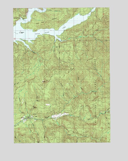
Cascadia, OR USGS Topographic Map
Click on map above to begin viewing in our Map Viewer.

This topographic map contains these locations and features:
Feature Name Type Latitude Longitude GNIS ID View Map
Bucksnort CreekStreamN44.3973°W122.4862°1138876View Map
Cabin CreekStreamN44.3985°W122.4837°1139101View Map
Canyon CreekStreamN44.3976°W122.4490°1139330View Map
CascadiaPopulated PlaceN44.3973°W122.4817°1139425View Map
Cascadia Post OfficePost OfficeN44.3967°W122.4849°1165020View Map
Cascadia School (historical)SchoolN44.3943°W122.4901°1162204View Map
Cascadia State ParkParkN44.3982°W122.4729°1139426View Map
Cub CreekStreamN44.4293°W122.3854°1140522View Map
Dobbin CreekStreamN44.3973°W122.4792°1141093View Map
Falls CreekStreamN44.4015°W122.3859°1142005View Map
Fools CanyonValleyN44.4982°W122.4601°1142291View Map
Garland BridgeBridgeN44.3971°W122.3956°1162202View Map
Green Peter LakeReservoirN44.4786°W122.4806°1158878View Map
Green Peter PeninsulaCapeN44.4887°W122.4581°1134600View Map
Hensley CreekStreamN44.4201°W122.4156°1143501View Map
High DeckSummitN44.4318°W122.4606°1143565View Map
Husted CreekStreamN44.4094°W122.4350°2558325View Map
Kronenberg Post Office (historical)Post OfficeN44.4943°W122.4868°1164449View Map
Lower Soda FallsFallsN44.4078°W122.4754°1145640View Map
Lowersoda Post Office (historical)Post OfficeN44.3962°W122.4640°1164486View Map
Lynchwood City ParkParkN44.4976°W122.4876°2040323View Map
Manzanita CreekStreamN44.4926°W122.4929°1134599View Map
Moose CreekStreamN44.4010°W122.4404°1146437View Map
Moose Creek FallsFallsN44.4040°W122.4401°1153404View Map
Moose RidgeRidgeN44.4551°W122.3895°1146440View Map
Queen CreekStreamN44.3804°W122.4198°1148101View Map
Rainbow FallsFallsN44.3756°W122.4684°1148171View Map
Roberts (historical)LocaleN44.4943°W122.4806°1148535View Map
Soda CreekStreamN44.3985°W122.4806°1149845View Map
Soda Stone Post Office (historical)Post OfficeN44.3993°W122.4270°1164694View Map
Strait CreekStreamN44.4721°W122.4817°1153403View Map
Sweet Home Fire and Ambulance District Station 24BuildingN44.3983°W122.4434°2576720View Map
Tally CreekStreamN44.4765°W122.4495°1150848View Map
Upper Soda FallsFallsN44.4147°W122.4717°1151706View Map
Whitcomb IslandIslandN44.4771°W122.4929°1154332View Map
Whitcomb Island CemeteryCemeteryN44.4773°W122.4928°1135183View Map
Whitcomb Post Office (historical)Post OfficeN44.4998°W122.4845°1164781View Map
Whiterock CreekStreamN44.4123°W122.4306°1152265View Map
Wolf CreekStreamN44.3962°W122.4640°1152582View Map

Note: Coordinates in the location and feature list above are referenced to NAD83 datum.


Copyright (C) 2008-2024 Ryan Niemi / Sunset Dynamics ... All Rights Reserved