TopoQuest Logo
Do you find TopoQuest useful?
Help keep TopoQuest running and adding new maps/features by donating!
Bitcoin:  19c7KJd3qBynnjoSw5npx9KScwjBe4ifkT
Litecoin:  LXs6TkuXGGXo1vDsWCkWVdjQX94eUKd6ui
Home View Maps Find Maps Find Places Resources & Links


Alton, Indiana Topographic Map

USGS Map Title: Alton, IN
USGS Map MRC: 38086A4
DRG (GeoTIFF) Download: o38086a4.tif


Neighboring USGS Topographic Map Quads:


  Branchville, IN  
38086B5
 

  Beechwood, IN  
38086B4
 

  Leavenworth, IN  
38086B3
 

  Derby, IN  
38086A5
 

  Alton, IN  
38086A4
 

  New Amsterdam, IN  
38086A3
 

  Rome, IN  
37086H5
 

  Lodiburg, KY  
37086H4
 

  Irvington, KY  
37086H3


Map MRC Location:

N39°
W87°
N39°
W86°
H8 H7 H6 H5 H4 H3 H2 H1
G8 G7 G6 G5 G4 G3 G2 G1
F8 F7 F6 F5 F4 F3 F2 F1
E8 E7 E6 E5 E4 E3 E2 E1
D8 D7 D6 D5 D4 D3 D2 D1
C8 C7 C6 C5 C4 C3 C2 C1
B8 B7 B6 B5 B4 B3 B2 B1
A8 A7 A6 A5 A4 A3 A2 A1
N38°
W87°
N38°
W86°

Alton, IN USGS 1:24K Topographic Map Preview:
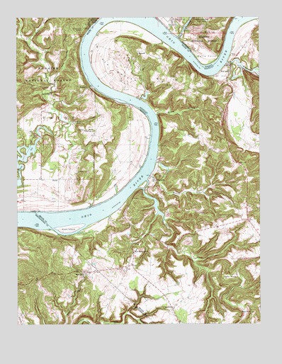
Alton, IN USGS Topographic Map
Click on map above to begin viewing in our Map Viewer.

This topographic map contains these locations and features:
Feature Name Type Latitude Longitude GNIS ID View Map
AltonPopulated PlaceN38.1226°W86.4178°450627View Map
Barr CemeteryCemeteryN38.0651°W86.3847°486423View Map
Bear CreekStreamN38.0823°W86.4722°450660View Map
Boone CreekStreamN38.1142°W86.4936°450696View Map
Boone HollowValleyN38.0858°W86.4278°487696View Map
Bulls PointCapeN38.1092°W86.4016°450731View Map
Buzzard Roost OverlookLocaleN38.1201°W86.4655°450743View Map
ConcordiaPopulated PlaceN38.0590°W86.4280°489947View Map
Cross Roads ChurchChurchN38.0790°W86.4597°450822View Map
Dark HollowValleyN38.1004°W86.4812°450828View Map
DexterPopulated PlaceN38.0592°W86.4786°450847View Map
Eagle's Nest AirportAirportN38.1033°W86.4569°2444068View Map
Flint IslandIslandN38.0384°W86.4736°492249View Map
Jarbo SinksBasinN38.0195°W86.3908°495172View Map
Leavenworth Fire Department Station 2BuildingN38.1229°W86.4182°2626264View Map
Little BendBendN38.1017°W86.4316°496621View Map
Little Blue RiverStreamN38.1170°W86.4166°451153View Map
MagnetPopulated PlaceN38.0967°W86.4633°451192View Map
Mill CreekStreamN38.0476°W86.4630°451216View Map
MooleyvillePopulated PlaceN38.0212°W86.4639°498523View Map
Owens CemeteryCemeteryN38.1098°W86.3869°500071View Map
Peters LandingLocaleN38.0467°W86.4500°507323View Map
RhodeliaPopulated PlaceN38.0070°W86.4205°508929View Map
Rhodelia Fire DepartmentBuildingN38.0272°W86.4399°2636781View Map
RobertaPopulated PlaceN38.1106°W86.4378°508949View Map
Sacred Heart ChurchChurchN38.0940°W86.4819°451412View Map
Saint Theresa AcademySchoolN38.0298°W86.4389°502747View Map
Spring CreekStreamN38.0590°W86.4333°504126View Map
Stephenson CemeteryCemeteryN38.0623°W86.4628°451510View Map
Stony PointLocaleN38.0051°W86.3797°504514View Map
Town of AltonCivilN38.1211°W86.4193°2397425View Map
Watson RunStreamN38.0662°W86.4286°506291View Map
Willets BottomBendN38.1042°W86.4514°506776View Map
Wolf CreekPopulated PlaceN38.1028°W86.3897°506992View Map
Wolf CreekStreamN38.1067°W86.3916°507002View Map
Wolf Creek Fire DepartmentBuildingN38.0861°W86.3938°2636706View Map

Note: Coordinates in the location and feature list above are referenced to NAD83 datum.


Copyright (C) 2008-2025 Ryan Niemi / Sunset Dynamics ... All Rights Reserved