TopoQuest Logo
Do you find TopoQuest useful?
Help keep TopoQuest running and adding new maps/features by donating!
Bitcoin:  19c7KJd3qBynnjoSw5npx9KScwjBe4ifkT
Litecoin:  LXs6TkuXGGXo1vDsWCkWVdjQX94eUKd6ui
Home View Maps Find Maps Find Places Resources & Links


Bacliff, Texas Topographic Map

USGS Map Title: Bacliff, TX
USGS Map MRC: 29094E8
DRG (GeoTIFF) Download: o29094e8.tif


Neighboring USGS Topographic Map Quads:


  La Porte, TX  
29095F1
 

  Morgans Point, TX  
29094F8
 

  Umbrella Point, TX  
29094F7
 

  League City, TX  
29095E1
 

  Bacliff, TX  
29094E8
 

  Smith Point, TX  
29094E7
 

  Dickinson, TX  
29095D1
 

  Texas City, TX  
29094D8
 

  Port Bolivar, TX  
29094D7


Map MRC Location:

N30°
W95°
N30°
W94°
H8 H7 H6 H5 H4 H3 H2 H1
G8 G7 G6 G5 G4 G3 G2 G1
F8 F7 F6 F5 F4 F3 F2 F1
E8 E7 E6 E5 E4 E3 E2 E1
D8 D7 D6 D5 D4 D3 D2 D1
C8 C7 C6 C5 C4 C3 C2 C1
B8 B7 B6 B5 B4 B3 B2 B1
A8 A7 A6 A5 A4 A3 A2 A1
N29°
W95°
N29°
W94°

Bacliff, TX USGS 1:24K Topographic Map Preview:
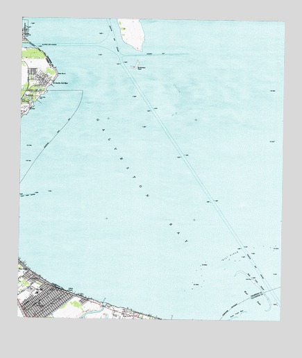
Bacliff, TX USGS Topographic Map
Click on map above to begin viewing in our Map Viewer.

This topographic map contains these locations and features:
Feature Name Type Latitude Longitude GNIS ID View Map
BacliffPopulated PlaceN29.5069°W94.9924°1329909View Map
Bacliff Census Designated PlaceCensusN29.5077°W94.9881°2407791View Map
Bacliff Post OfficePost OfficeN29.5071°W94.9823°2731089View Map
Bacliff Volunteer Fire DepartmentBuildingN29.5060°W94.9851°2334593View Map
Bayshore ChurchChurchN29.5163°W94.9944°1330168View Map
Bayshore ParkParkN29.5041°W94.9546°2028824View Map
Bulkhead ReefBarN29.6016°W94.9455°1331586View Map
Camp County Public LibraryBuildingN29.5138°W94.9896°2015047View Map
Chase ParkPopulated PlaceN29.5032°W94.9882°2471758View Map
City of SeabrookCivilN29.5706°W94.9839°2411847View Map
Clear Creek ChannelChannelN29.5319°W94.8969°1332938View Map
Clifton BeachPopulated PlaceN29.5113°W94.9771°1332989View Map
Clifton ChannelChannelN29.5111°W94.9652°1332992View Map
El Jardin Del MarPopulated PlaceN29.5986°W94.9880°1335199View Map
Ellis Airport (historical)AirportN29.5002°W94.9502°1387498View Map
First Baptist Church of BacliffChurchN29.5080°W94.9858°2018755View Map
Fivemile PassGapN29.6097°W94.9471°1335863View Map
Galveston BayBayN29.5697°W94.9366°1381144View Map
Galveston County Constable's Office Precinct 1BuildingN29.5034°W94.9878°2751251View Map
Galveston County Constable's Office Precinct 7BuildingN29.5050°W94.9875°2751439View Map
Kenneth E Little Elementary SchoolSchoolN29.5095°W94.9919°2005618View Map
Middle PassGapN29.5680°W94.9213°1341508View Map
Pasadena Volunteer Fire Department Station 9BuildingN29.6001°W94.9914°2334780View Map
Pine GullyValleyN29.5901°W94.9944°1375464View Map
Red BluffPopulated PlaceN29.6108°W94.9910°1375657View Map
Red BluffCliffN29.6016°W94.9827°1344891View Map
Red Fish IslandIslandN29.5183°W94.8919°1344913View Map
Red Fish Island ShoalBarN29.5122°W94.8844°2744134View Map
Seabrook CemeteryCemeteryN29.5919°W94.9952°1346841View Map
Surf OaksPopulated PlaceN29.5891°W94.9963°1379133View Map
Texas Corinthian Yacht Club MarinaLocaleN29.5122°W94.9788°2030444View Map
West PassGapN29.5052°W94.8864°1349780View Map

Note: Coordinates in the location and feature list above are referenced to NAD83 datum.


Copyright (C) 2008-2024 Ryan Niemi / Sunset Dynamics ... All Rights Reserved