TopoQuest Logo
Do you find TopoQuest useful?
Help keep TopoQuest running and adding new maps/features by donating!
Bitcoin:  19c7KJd3qBynnjoSw5npx9KScwjBe4ifkT
Litecoin:  LXs6TkuXGGXo1vDsWCkWVdjQX94eUKd6ui
Home View Maps Find Maps Find Places Resources & Links


Mount Pleasant, North Carolina Topographic Map

USGS Map Title: Mount Pleasant, NC
USGS Map MRC: 35080D4
DRG (GeoTIFF) Download: o35080d4.tif


Neighboring USGS Topographic Map Quads:


  China Grove, NC  
35080E5
 

  Rockwell, NC  
35080E4
 

  Gold Hill, NC  
35080E3
 

  Concord, NC  
35080D5
 

  Mount Pleasant, NC  
35080D4
 

  Richfield, NC  
35080D3
 

  Concord SE, NC  
35080C5
 

  Locust, NC  
35080C4
 

  Frog Pond, NC  
35080C3


Map MRC Location:

N36°
W81°
N36°
W80°
H8 H7 H6 H5 H4 H3 H2 H1
G8 G7 G6 G5 G4 G3 G2 G1
F8 F7 F6 F5 F4 F3 F2 F1
E8 E7 E6 E5 E4 E3 E2 E1
D8 D7 D6 D5 D4 D3 D2 D1
C8 C7 C6 C5 C4 C3 C2 C1
B8 B7 B6 B5 B4 B3 B2 B1
A8 A7 A6 A5 A4 A3 A2 A1
N35°
W81°
N35°
W80°

Mount Pleasant, NC USGS 1:24K Topographic Map Preview:
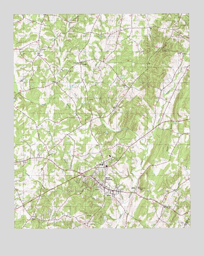
Mount Pleasant, NC USGS Topographic Map
Click on map above to begin viewing in our Map Viewer.

This topographic map contains these locations and features:
Feature Name Type Latitude Longitude GNIS ID View Map
Adams CreekStreamN35.3801°W80.4248°980040View Map
Black Run CreekStreamN35.4390°W80.4390°1023837View Map
Boger ChurchChurchN35.4718°W80.4559°981678View Map
Butcher BranchStreamN35.4424°W80.3951°982328View Map
Cabarrus County Emergency Medical Services Station 3BuildingN35.4122°W80.4334°2720618View Map
Camp SpencerLocaleN35.4632°W80.4940°982552View Map
Charity ChurchChurchN35.4235°W80.4398°1024711View Map
Cline SchoolSchoolN35.4601°W80.4701°983290View Map
Cold Springs ChurchChurchN35.3813°W80.4867°983355View Map
Concord Airport (historical)AirportN35.3824°W80.4903°1001155View Map
FaggartLocaleN35.3824°W80.4873°1001165View Map
Glorieta ChurchChurchN35.4143°W80.4940°1001021View Map
Jennie Wolf CreekStreamN35.4418°W80.4548°987563View Map
Little Buffalo CreekStreamN35.4207°W80.4062°1024090View Map
McAllister CreekStreamN35.4001°W80.4587°989521View Map
Mount Carmel ChurchChurchN35.4665°W80.4609°1001020View Map
Mount Gilead ChurchChurchN35.3871°W80.3898°990383View Map
Mount Olive ChurchChurchN35.4574°W80.4226°990475View Map
Mount PleasantPopulated PlaceN35.3993°W80.4359°990517View Map
Mount Pleasant ChurchChurchN35.3824°W80.4448°1024712View Map
Mount Pleasant Community ParkParkN35.3971°W80.4312°1001179View Map
Mount Pleasant Fire and RescueBuildingN35.3996°W80.4352°2639805View Map
Mount Pleasant Post OfficePost OfficeN35.3980°W80.4358°2773841View Map
Oak Grove ChurchChurchN35.4501°W80.4465°1001019View Map
Prosperity ChurchChurchN35.4793°W80.4801°992857View Map
RimerPopulated PlaceN35.4749°W80.4834°993362View Map
Rimer Volunteer Fire DepartmentBuildingN35.4762°W80.4817°2638667View Map
Saint Johns ChurchChurchN35.4190°W80.4751°993945View Map
Town of Mount PleasantCivilN35.3816°W80.4293°2406212View Map
Township 6-RimertownCivilN35.4683°W80.4560°1026475View Map
Township 8-Mount PleasantCivilN35.4022°W80.4329°1026477View Map
Victory TempleChurchN35.4607°W80.4703°1024713View Map
Watts CrossroadsPopulated PlaceN35.4718°W80.4531°1023130View Map
West AirportAirportN35.4270°W80.4516°2679290View Map

Note: Coordinates in the location and feature list above are referenced to NAD83 datum.


Copyright (C) 2008-2025 Ryan Niemi / Sunset Dynamics ... All Rights Reserved