TopoQuest Logo
Do you find TopoQuest useful?
Help keep TopoQuest running and adding new maps/features by donating!
Bitcoin:  19c7KJd3qBynnjoSw5npx9KScwjBe4ifkT
Litecoin:  LXs6TkuXGGXo1vDsWCkWVdjQX94eUKd6ui
Home View Maps Find Maps Find Places Resources & Links


Cayucos, California Topographic Map

USGS Map Title: Cayucos, CA
USGS Map MRC: 35120D8
DRG (GeoTIFF) Download: o35120d8.tif


Neighboring USGS Topographic Map Quads:


  Cypress Mountain, CA  
35120E8
 

  York Mountain, CA  
35120E7


  Cayucos, CA  
35120D8


Map MRC Location:

N36°
W121°
N36°
W120°
H8 H7 H6 H5 H4 H3 H2 H1
G8 G7 G6 G5 G4 G3 G2 G1
F8 F7 F6 F5 F4 F3 F2 F1
E8 E7 E6 E5 E4 E3 E2 E1
D8 D7 D6 D5 D4 D3 D2 D1
C8 C7 C6 C5 C4 C3 C2 C1
B8 B7 B6 B5 B4 B3 B2 B1
A8 A7 A6 A5 A4 A3 A2 A1
N35°
W121°
N35°
W120°

Cayucos, CA USGS 1:24K Topographic Map Preview:
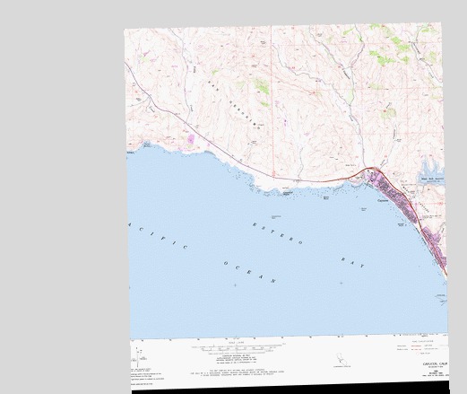
Cayucos, CA USGS Topographic Map
Click on map above to begin viewing in our Map Viewer.

This topographic map contains these locations and features:
Feature Name Type Latitude Longitude GNIS ID View Map
Black RockIslandN35.4441°W120.9241°239444View Map
California Department of Forestry and Fire Protection Station 11 CayucosBuildingN35.4212°W120.8763°2664803View Map
CayucosPopulated PlaceN35.4428°W120.8921°1656455View Map
Cayucos BeachBeachN35.4486°W120.9057°1703075View Map
Cayucos Branch San Luis Obispo City-County LibraryBuildingN35.4494°W120.9063°1872295View Map
Cayucos Census Designated PlaceCensusN35.4374°W120.8880°2407994View Map
Cayucos Chamber of CommerceBuildingN35.4494°W120.9046°1872296View Map
Cayucos Church of ChristChurchN35.4439°W120.8949°1872297View Map
Cayucos Community ChurchChurchN35.4469°W120.8980°1872298View Map
Cayucos CreekStreamN35.4494°W120.9082°255440View Map
Cayucos Elementary SchoolSchoolN35.4522°W120.9048°1872299View Map
Cayucos Fire Protection DistrictBuildingN35.4504°W120.9054°2664600View Map
Cayucos PierLocaleN35.4478°W120.9071°1703076View Map
Cayucos PointCapeN35.4464°W120.9402°240374View Map
Cayucos Post OfficePost OfficeN35.4495°W120.9035°1872300View Map
Cayucos State BeachParkN35.4489°W120.9052°240375View Map
Cayucos-Morro Bay District CemeteryCemeteryN35.4378°W120.8859°240376View Map
China HarborBayN35.4616°W120.9927°240552View Map
Constantine RockBarN35.4386°W120.9452°240867View Map
Ellysly CreekStreamN35.4625°W120.9721°241980View Map
Estero BayBayN35.4294°W120.9302°271081View Map
Estero Bluffs State ParkParkN35.4605°W120.9653°2570597View Map
Hardie ParkParkN35.4519°W120.9066°1872310View Map
Harmony Headlands State ParkParkN35.4776°W120.9924°2570604View Map
Little Cayucos CreekStreamN35.4475°W120.9035°244904View Map
Morro Strand State BeachParkN35.4278°W120.8830°246229View Map
Mouse RockBarN35.4405°W120.9093°246315View Map
Old CreekStreamN35.4347°W120.8868°272781View Map
Point EsteroCapeN35.4630°W121.0021°254160View Map
Saint Josephs Roman Catholic ChurchChurchN35.4455°W120.8982°1872319View Map
San GeronimoCivilN35.4839°W120.9696°248855View Map
Someo School (historical)SchoolN35.4853°W120.9766°1670573View Map
Veterans Memorial BuildingBuildingN35.4491°W120.9063°1872325View Map
Villa CreekStreamN35.4603°W120.9702°251044View Map
Whale RockBarN35.4350°W120.8924°251431View Map
Whale Rock 1-040 DamDamN35.4483°W120.8860°1663243View Map
Whale Rock ReservoirReservoirN35.4501°W120.8766°274456View Map
Willow CreekStreamN35.4278°W120.8830°274516View Map

Note: Coordinates in the location and feature list above are referenced to NAD83 datum.


Copyright (C) 2008-2025 Ryan Niemi / Sunset Dynamics ... All Rights Reserved