TopoQuest Logo
Do you find TopoQuest useful?
Help keep TopoQuest running and adding new maps/features by donating!
Bitcoin:  19c7KJd3qBynnjoSw5npx9KScwjBe4ifkT
Litecoin:  LXs6TkuXGGXo1vDsWCkWVdjQX94eUKd6ui
Home View Maps Find Maps Find Places Resources & Links


Cedarville, Michigan Topographic Map

USGS Map Title: Cedarville, MI
USGS Map MRC: 45084H3
DRG (GeoTIFF) Download: o45084h3.tif


Neighboring USGS Topographic Map Quads:


  Hessel, MI  
46084A4
 

  Pickford SE, MI  
46084A3
 

  Stalwart, MI  
46084A2
 

  Goose Island, MI  
45084H4
 

  Cedarville, MI  
45084H3
 

  Prentiss Bay, MI  
45084H2
 

  McRae Bay, MI  
45084G4


Map MRC Location:

N46°
W85°
N46°
W84°
H8 H7 H6 H5 H4 H3 H2 H1
G8 G7 G6 G5 G4 G3 G2 G1
F8 F7 F6 F5 F4 F3 F2 F1
E8 E7 E6 E5 E4 E3 E2 E1
D8 D7 D6 D5 D4 D3 D2 D1
C8 C7 C6 C5 C4 C3 C2 C1
B8 B7 B6 B5 B4 B3 B2 B1
A8 A7 A6 A5 A4 A3 A2 A1
N45°
W85°
N45°
W84°

Cedarville, MI USGS 1:24K Topographic Map Preview:
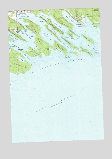
Cedarville, MI USGS Topographic Map
Click on map above to begin viewing in our Map Viewer.

This topographic map contains these locations and features:
Feature Name Type Latitude Longitude GNIS ID View Map
Ailes PointCapeN45.9934°W84.3548°1619000View Map
Arnold PointCapeN45.9653°W84.3484°620242View Map
Bass Cove LakeLakeN45.9622°W84.3184°1623054View Map
Bay PointCapeN45.9820°W84.3295°1617963View Map
Beach Post Office (historical)Post OfficeN45.9847°W84.3628°2358657View Map
Boot IslandIslandN45.9603°W84.2745°1619283View Map
Bosely ChannelChannelN45.9606°W84.3353°621751View Map
Bush BayBayN45.9864°W84.2678°1619379View Map
CedarvillePopulated PlaceN45.9981°W84.3631°1617481View Map
Cedarville BayBayN45.9945°W84.3542°1619467View Map
Cedarville Harbor ParkParkN45.9964°W84.3600°2359940View Map
Cedarville Post OfficePost OfficeN45.9981°W84.3633°2359945View Map
Cedarville RV Park and CampgroundLocaleN45.9972°W84.3494°2359939View Map
Clark Township Volunteer Fire DepartmentBuildingN45.9962°W84.3634°2359951View Map
Connors PointCapeN45.9706°W84.3514°623708View Map
Coryell IslandIslandN45.9656°W84.2897°1623167View Map
Coryell Islands Post Office (historical)Post OfficeN45.9717°W84.3014°2358650View Map
Cove IslandIslandN45.9734°W84.2986°623906View Map
Crow PointCapeN45.9739°W84.2809°1619630View Map
East EntranceChannelN45.9634°W84.2634°1619812View Map
First Union ChurchChurchN45.9964°W84.3589°2359949View Map
Fishery Island PointCapeN45.9725°W84.2872°1617979View Map
Flowers BayBayN45.9942°W84.3267°1619938View Map
Flowers CreekStreamN45.9939°W84.3189°1619939View Map
Government BayBayN45.9736°W84.3220°1620048View Map
Government IslandIslandN45.9639°W84.3050°627028View Map
Gravelly IslandIslandN45.9578°W84.2581°1620069View Map
Hill ChannelChannelN45.9803°W84.3148°628273View Map
Hill IslandIslandN45.9839°W84.3136°1620207View Map
Holsinger IslandIslandN45.9750°W84.3411°628463View Map
Hossack Memorial ParkParkN45.9983°W84.3569°2359941View Map
Island Number EightIslandN45.9784°W84.3161°629129View Map
Islington BayBayN45.9753°W84.3489°1620340View Map
Islington PointCapeN45.9811°W84.3500°1620341View Map
Islington Post Office (historical)Post OfficeN45.9750°W84.3625°2358149View Map
Jocker PointCapeN45.9778°W84.2975°1620368View Map
La Salle IslandIslandN45.9753°W84.3356°629909View Map
Lazy Days CampgroundLocaleN45.9978°W84.3633°2359937View Map
Les Cheneaux Community SchoolSchoolN45.9989°W84.3564°2359950View Map
Les Cheneaux Historical MuseumBuildingN45.9981°W84.3628°2359947View Map
Les Cheneaux IslandsIslandN45.9595°W84.3248°630325View Map
Little IslandIslandN45.9720°W84.2836°1620556View Map
Little La Salle IslandIslandN45.9597°W84.3436°630656View Map
Loon PointCapeN45.9942°W84.3345°1620623View Map
Loons Point CampgroundLocaleN45.9950°W84.3361°2359938View Map
Magulpin ChannelChannelN45.9645°W84.3150°631327View Map
Maritime MuseumBuildingN45.9983°W84.3519°2359946View Map
McKay BayBayN45.9900°W84.2917°631930View Map
McKay CreekStreamN45.9981°W84.2986°1620769View Map
Melchers PointCapeN45.9797°W84.3564°632079View Map
Middle EntranceChannelN45.9561°W84.3514°1620814View Map
Middle Entrance PointCapeN45.9617°W84.3581°632245View Map
Moscoe ChannelChannelN45.9842°W84.3075°1620905View Map
Muscallonge BayBayN45.9667°W84.3625°1620961View Map
Pearson CreekStreamN45.9959°W84.3642°1621178View Map
Peck BayBayN45.9531°W84.3584°634545View Map
Penny IslandIslandN45.9545°W84.2956°1621199View Map
Pleasant PointCapeN45.9722°W84.3684°1623055View Map
Point PiretCapeN45.9550°W84.2634°1625041View Map
Point Shab-wa-wayCapeN45.9553°W84.2828°1625042View Map
Port DolomitePopulated PlaceN45.9847°W84.2750°1621295View Map
Sand BayBayN45.9559°W84.3375°1623053View Map
Scammon CoveBayN45.9653°W84.2972°1621531View Map
Sheppard BayBayN45.9778°W84.3584°637742View Map
Strongs IslandIslandN45.9709°W84.2675°1621801View Map
Urie BayBayN45.9653°W84.3403°1615433View Map
Urie PointCapeN45.9697°W84.3414°1622007View Map
White Loon IslandIslandN45.9881°W84.3273°1616320View Map
Wisner PointCapeN45.9656°W84.3731°1622193View Map

Note: Coordinates in the location and feature list above are referenced to NAD83 datum.


Copyright (C) 2008-2024 Ryan Niemi / Sunset Dynamics ... All Rights Reserved