TopoQuest Logo
Do you find TopoQuest useful?
Help keep TopoQuest running and adding new maps/features by donating!
Bitcoin:  19c7KJd3qBynnjoSw5npx9KScwjBe4ifkT
Litecoin:  LXs6TkuXGGXo1vDsWCkWVdjQX94eUKd6ui
Home View Maps Find Maps Find Places Resources & Links


Alva SW, Florida Topographic Map

USGS Map Title: Alva SW, FL
USGS Map MRC: 26081E6
DRG (GeoTIFF) Download: o26081e6.tif


Neighboring USGS Topographic Map Quads:


  Fort Myers, FL  
26081F7
 

  Olga, FL  
26081F6
 

  Alva, FL  
26081F5
 

  Fort Myers SE, FL  
26081E7
 

  Alva SW, FL  
26081E6
 

  Alva SE, FL  
26081E5
 

  Estero, FL  
26081D7
 

  Corkscrew NW, FL  
26081D6
 

  Corkscrew, FL  
26081D5


Map MRC Location:

N27°
W82°
N27°
W81°
H8 H7 H6 H5 H4 H3 H2 H1
G8 G7 G6 G5 G4 G3 G2 G1
F8 F7 F6 F5 F4 F3 F2 F1
E8 E7 E6 E5 E4 E3 E2 E1
D8 D7 D6 D5 D4 D3 D2 D1
C8 C7 C6 C5 C4 C3 C2 C1
B8 B7 B6 B5 B4 B3 B2 B1
A8 A7 A6 A5 A4 A3 A2 A1
N26°
W82°
N26°
W81°

Alva SW, FL USGS 1:24K Topographic Map Preview:
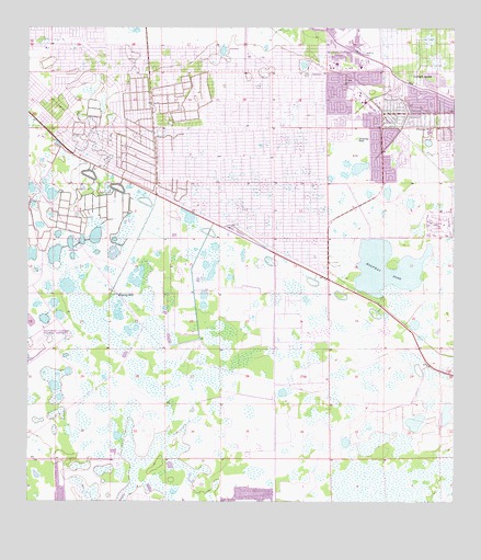
Alva SW, FL USGS Topographic Map
Click on map above to begin viewing in our Map Viewer.

This topographic map contains these locations and features:
Feature Name Type Latitude Longitude GNIS ID View Map
Able CanalCanalN26.6156°W81.6451°277664View Map
Caloosahatchee Forestry CenterBuildingN26.5984°W81.6399°2644545View Map
Christ United Methodist Church of Lehigh AcresChurchN26.6135°W81.6535°2450522View Map
First Church of Christ ScientistChurchN26.6111°W81.6410°2450525View Map
Gateway Census Designated PlaceCensusN26.5804°W81.7452°2402518View Map
Halfway PondLakeN26.5604°W81.6451°283612View Map
Homestead Shopping CenterLocaleN26.5240°W81.7262°296661View Map
Korean Assembly of God Church of Fort MyersChurchN26.5837°W81.6458°2450526View Map
Lake Camille Shopping CenterLocaleN26.5934°W81.7276°296662View Map
Las Colinas Golf CourseLocaleN26.5745°W81.6298°2450519View Map
Lauderhills Golf CourseLocaleN26.6041°W81.7316°2450520View Map
Lee Boulevard Baptist ChurchChurchN26.6166°W81.6794°2450527View Map
Lee Boulevard Shopping CenterLocaleN26.5934°W81.7429°296664View Map
Lee County Port Authority Fire Rescue - Station 92BuildingN26.5325°W81.7482°2644542View Map
Lee County Sheriff's Office Bravo East DistrictBuildingN26.6083°W81.6523°2333699View Map
Lee Memorial Garden CemeteryCemeteryN26.5937°W81.7492°300916View Map
Lehigh Acres Census Designated PlaceCensusN26.6120°W81.6388°2403226View Map
Lehigh Acres Christian AcademySchoolN26.5837°W81.6465°301508View Map
Lehigh Acres Church of the NazareneChurchN26.6098°W81.6410°2450529View Map
Lehigh Acres DivisionCivilN26.5702°W81.6902°1935832View Map
Lehigh Acres Fire Control and Rescue District Station 103BuildingN26.6090°W81.7144°2131571View Map
Lehigh Acres Fire Control and Rescue Station 104BuildingN26.5987°W81.6796°2644544View Map
Lehigh Acres Fire Department Control and Rescue District Station 102BuildingN26.5983°W81.6399°2131570View Map
Lehigh Acres Middle SchoolSchoolN26.5982°W81.6320°298459View Map
Lehigh Acres Post OfficePost OfficeN26.6043°W81.6521°2450521View Map
Lehigh Elementary SchoolSchoolN26.6092°W81.6269°297971View Map
Lehigh Memorial ParkCemeteryN26.6003°W81.6526°298553View Map
Lehigh Regional Medical CenterHospitalN26.6159°W81.6595°298695View Map
Sunshine Plaza and MallLocaleN26.5879°W81.7359°296663View Map
Trinity Baptist ChapelChurchN26.6175°W81.7073°2450532View Map

Note: Coordinates in the location and feature list above are referenced to NAD83 datum.


Copyright (C) 2008-2025 Ryan Niemi / Sunset Dynamics ... All Rights Reserved