TopoQuest Logo
Do you find TopoQuest useful?
Help keep TopoQuest running and adding new maps/features by donating!
Bitcoin:  19c7KJd3qBynnjoSw5npx9KScwjBe4ifkT
Litecoin:  LXs6TkuXGGXo1vDsWCkWVdjQX94eUKd6ui
Home View Maps Find Maps Find Places Resources & Links


Center Sandwich, New Hampshire Topographic Map

USGS Map Title: Center Sandwich, NH
USGS Map MRC: 43071G4
DRG (GeoTIFF) Download: o43071g4.tif


Neighboring USGS Topographic Map Quads:


  Waterville Valley, NH  
43071H5
 

  Mount Tripyramid, NH  
43071H4
 

  Mount Chocorua, NH  
43071H3
 

  Squam Mountains, NH  
43071G5
 

  Center Sandwich, NH  
43071G4
 

  Tamworth, NH  
43071G3
 

  Holderness, NH  
43071F5
 

  Center Harbor, NH  
43071F4
 

  Melvin Village, NH  
43071F3


Map MRC Location:

N44°
W72°
N44°
W71°
H8 H7 H6 H5 H4 H3 H2 H1
G8 G7 G6 G5 G4 G3 G2 G1
F8 F7 F6 F5 F4 F3 F2 F1
E8 E7 E6 E5 E4 E3 E2 E1
D8 D7 D6 D5 D4 D3 D2 D1
C8 C7 C6 C5 C4 C3 C2 C1
B8 B7 B6 B5 B4 B3 B2 B1
A8 A7 A6 A5 A4 A3 A2 A1
N43°
W72°
N43°
W71°

Center Sandwich, NH USGS 1:24K Topographic Map Preview:
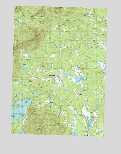
Center Sandwich, NH USGS Topographic Map
Click on map above to begin viewing in our Map Viewer.

This topographic map contains these locations and features:
Feature Name Type Latitude Longitude GNIS ID View Map
Barville PondLakeN43.7903°W71.4677°871451View Map
Beede FallsFallsN43.8276°W71.4954°871484View Map
Berry PondLakeN43.7633°W71.3941°871493View Map
Big Rock CornerPopulated PlaceN43.7812°W71.4492°871505View Map
Black Mountain Pond TrailTrailN43.8603°W71.4956°871369View Map
Bragg LedgeBenchN43.8476°W71.3854°871574View Map
Browns PointCapeN43.7648°W71.4981°871584View Map
Burley HillSummitN43.8042°W71.4534°871592View Map
Burrows BrookStreamN43.7917°W71.4709°873100View Map
Buzzell RidgeRidgeN43.7976°W71.4631°871600View Map
Camp HaleLocaleN43.7851°W71.4756°873101View Map
Center SandwichPopulated PlaceN43.8076°W71.4392°871655View Map
Center Sandwich Census Designated PlaceCensusN43.8084°W71.4394°2629720View Map
Center Sandwich Historic DistrictParkN43.8073°W71.4398°1915908View Map
Center Sandwich Post OfficePost OfficeN43.8059°W71.4378°1915909View Map
Chicks CornerPopulated PlaceN43.8029°W71.4729°871671View Map
Cook BrookStreamN43.7909°W71.4445°871725View Map
Diamond LedgeSummitN43.8170°W71.4631°871783View Map
Dinsmore MountainSummitN43.8420°W71.4987°871787View Map
Dinsmore PondLakeN43.8149°W71.4821°871788View Map
Eagle CliffCliffN43.7723°W71.4712°871819View Map
Elm Hill CemeteryCemeteryN43.8156°W71.4342°871861View Map
Federated ChurchChurchN43.8073°W71.4390°1915955View Map
Federated ChurchChurchN43.8081°W71.4392°1915956View Map
Fore PointCapeN43.7759°W71.4876°871896View Map
Free Will Baptist Church (historical)ChurchN43.8073°W71.4390°1915966View Map
Garland PondLakeN43.7513°W71.4117°871926View Map
Grove CemeteryCemeteryN43.8099°W71.4446°871978View Map
Guinea HillSummitN43.8609°W71.4606°871981View Map
Guinea PondLakeN43.8608°W71.4902°871982View Map
Guinea Pond TrailTrailN43.8620°W71.4837°871371View Map
Hale CoveBayN43.7851°W71.4759°1877368View Map
Heath BrookStreamN43.8395°W71.3859°872028View Map
Kent IslandIslandN43.7673°W71.4870°872135View Map
Kusumpe PondLakeN43.7871°W71.4938°872147View Map
Little PondLakeN43.7944°W71.4029°872194View Map
Little Pond CemeteryCemeteryN43.7914°W71.4034°872195View Map
Lower Corner Historic DistrictParkN43.7909°W71.4109°1916031View Map
Maple RidgeRidgeN43.8581°W71.4262°872254View Map
Mason CemeteryCemeteryN43.7576°W71.4182°872263View Map
Mead TrailTrailN43.8503°W71.4840°872270View Map
Mead Wilderness Base Organization CampLocaleN43.8251°W71.4829°873104View Map
Montgomery BrookStreamN43.7940°W71.4440°872314View Map
Moultonboro AirportAirportN43.7692°W71.3859°873423View Map
Moultonboro United Methodist ChurchChurchN43.7551°W71.3959°1916049View Map
MoultonboroughPopulated PlaceN43.7548°W71.3967°872333View Map
Moultonborough Academy High SchoolSchoolN43.7511°W71.3961°2500294View Map
Moultonborough Academy Middle SchoolSchoolN43.7511°W71.3961°2500292View Map
Moultonborough Fire and RescueBuildingN43.7564°W71.3943°2605081View Map
Moultonborough Police DepartmentBuildingN43.7567°W71.3939°2753011View Map
Moultonborough Post OfficePost OfficeN43.7546°W71.3972°1916047View Map
Mount IsraelSummitN43.8456°W71.4723°872089View Map
North SandwichPopulated PlaceN43.8406°W71.3970°872406View Map
North Sandwich Post OfficePost OfficeN43.8399°W71.3975°1916069View Map
Otter CoveBayN43.7795°W71.4965°872443View Map
Pond BrookStreamN43.8670°W71.3995°872517View Map
Red HillSummitN43.7556°W71.4587°872553View Map
Red Hill PondLakeN43.8063°W71.4126°872554View Map
Red Hill State Lookout TowerTowerN43.7556°W71.4579°873099View Map
SandwichPopulated PlaceN43.7904°W71.4112°872619View Map
Sandwich BayBayN43.7812°W71.4792°872620View Map
Sandwich Central SchoolSchoolN43.8059°W71.4408°1916105View Map
Sandwich FairgroundsLocaleN43.8040°W71.4384°1916106View Map
Sandwich Fire Rescue Department Central StationBuildingN43.8030°W71.4336°2605281View Map
Sandwich Fire Rescue Department White Face StationBuildingN43.8632°W71.3959°2605225View Map
Sandwich LandingPopulated PlaceN43.7851°W71.4709°872621View Map
Sandwich Police DepartmentBuildingN43.8102°W71.4357°2752890View Map
Sandwich Post OfficePost OfficeN43.7906°W71.4115°1916107View Map
Skinner BrookStreamN43.7823°W71.4262°872669View Map
Stanton BrookStreamN43.8098°W71.4304°872728View Map
Teacup LakeLakeN43.8573°W71.4412°872776View Map
Thompson SanctuaryParkN43.8384°W71.3792°1916132View Map
Tilton BrookStreamN43.8620°W71.3870°872818View Map
Top of the WorldSummitN43.8156°W71.4023°872825View Map
Town of SandwichCivilN43.8393°W71.4468°873717View Map
Watson LedgeBenchN43.7598°W71.4392°872872View Map
Weed BrookStreamN43.7720°W71.4145°872878View Map
Wentworth HillPopulated PlaceN43.7915°W71.4131°872887View Map
Wentworth TrailTrailN43.8367°W71.4829°872889View Map
White ChurchChurchN43.8556°W71.3917°872908View Map
WhitefacePopulated PlaceN43.8667°W71.3981°872916View Map
Whiteface RiverStreamN43.8637°W71.3892°872919View Map

Note: Coordinates in the location and feature list above are referenced to NAD83 datum.


Copyright (C) 2008-2024 Ryan Niemi / Sunset Dynamics ... All Rights Reserved