TopoQuest Logo
Do you find TopoQuest useful?
Help keep TopoQuest running and adding new maps/features by donating!
Bitcoin:  19c7KJd3qBynnjoSw5npx9KScwjBe4ifkT
Litecoin:  LXs6TkuXGGXo1vDsWCkWVdjQX94eUKd6ui
Home View Maps Find Maps Find Places Resources & Links


Centerville, Louisiana Topographic Map

USGS Map Title: Centerville, LA
USGS Map MRC: 29091G4
DRG (GeoTIFF) Download: o29091g4.tif


Neighboring USGS Topographic Map Quads:


  Charenton, LA  
29091H5
 

  Centerville NW, LA  
29091H4
 

  Centerville NE, LA  
29091H3
 

  Franklin, LA  
29091G5
 

  Centerville, LA  
29091G4
 

  Tiger Island, LA  
29091G3
 

  Ellerslie, LA  
29091F5
 

  North Bend, LA  
29091F4
 

  Patterson, LA  
29091F3


Map MRC Location:

N30°
W92°
N30°
W91°
H8 H7 H6 H5 H4 H3 H2 H1
G8 G7 G6 G5 G4 G3 G2 G1
F8 F7 F6 F5 F4 F3 F2 F1
E8 E7 E6 E5 E4 E3 E2 E1
D8 D7 D6 D5 D4 D3 D2 D1
C8 C7 C6 C5 C4 C3 C2 C1
B8 B7 B6 B5 B4 B3 B2 B1
A8 A7 A6 A5 A4 A3 A2 A1
N29°
W92°
N29°
W91°

Centerville, LA USGS 1:24K Topographic Map Preview:
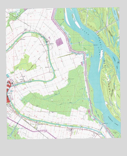
Centerville, LA USGS Topographic Map
Click on map above to begin viewing in our Map Viewer.

This topographic map contains these locations and features:
Feature Name Type Latitude Longitude GNIS ID View Map
Bayou Teche National Wildlife RefugeParkN29.7530°W91.4978°2765192View Map
Belleview Country ClubLocaleN29.8141°W91.4493°560141View Map
Broken Pines Country ClubLocaleN29.8156°W91.4507°2601345View Map
CafferyPopulated PlaceN29.8058°W91.4796°560317View Map
CamperdownPopulated PlaceN29.8458°W91.4840°560325View Map
CentervillePopulated PlaceN29.7597°W91.4284°560387View Map
Centerville High SchoolSchoolN29.7583°W91.4297°551430View Map
Centerville Post OfficePost OfficeN29.7580°W91.4304°1631664View Map
Centerville Volunteer Fire DepartmentBuildingN29.7596°W91.4306°2332401View Map
Church of ChristChurchN29.8063°W91.4969°2601656View Map
Church of GodChurchN29.7744°W91.4959°551431View Map
City ParkParkN29.8030°W91.4973°551432View Map
East Franklin Gas FieldOilfieldN29.7816°W91.4459°551436View Map
Franklin Foundation HospitalHospitalN29.8045°W91.4991°551442View Map
Franklin Oil FieldOilfieldN29.7622°W91.4957°560795View Map
Garden CityPopulated PlaceN29.7655°W91.4657°560813View Map
Garden City Post OfficePost OfficeN29.7658°W91.4665°1631669View Map
Grace Presbyterian ChurchChurchN29.8028°W91.4998°2601808View Map
Gray Horse IsleIslandN29.7530°W91.3798°560898View Map
Grevemberg House MuseumBuildingN29.8024°W91.4968°551448View Map
Immaculate Conception ChurchChurchN29.7582°W91.3990°2601946View Map
Irish BendPopulated PlaceN29.8188°W91.4532°1627329View Map
Israelite CemeteryCemeteryN29.8346°W91.4993°1627334View Map
Little Zion CemeteryCemeteryN29.7508°W91.4057°1627544View Map
Louisiana Noname 50 DamDamN29.8102°W91.4968°1628798View Map
Louisiana State University AgCenter Saint Mary Parish OfficeLocaleN29.7913°W91.4995°2599986View Map
Miller PointCapeN29.8396°W91.4043°1627667View Map
Mount Horeb ChurchChurchN29.8405°W91.4593°1627713View Map
Nazarene Baptist ChurchChurchN29.7546°W91.4015°2602410View Map
OaklawnPopulated PlaceN29.8413°W91.4526°1627812View Map
Oaklawn BridgeBridgeN29.8405°W91.4552°2601258View Map
Oaklawn CanalCanalN29.8610°W91.4373°1627813View Map
Oaklawn CemeteryCemeteryN29.8477°W91.4618°1627814View Map
Oaklawn ManorBuildingN29.8496°W91.4668°551468View Map
OxfordPopulated PlaceN29.8541°W91.4787°1627850View Map
Palo Alto CemeteryCemeteryN29.8160°W91.4468°1627860View Map
Parish Governing Authority District 2CivilN29.8737°W91.4922°1929917View Map
Saint John ChurchChurchN29.8072°W91.4734°1628125View Map
Saint Joseph Baptist ChurchChurchN29.8041°W91.4874°2602662View Map
Saint Mary Parish Alternative SchoolSchoolN29.7546°W91.4047°2493317View Map
Saint Mary Parish CourthouseBuildingN29.7913°W91.4996°551478View Map
Saint Mary Parish Police JuryBuildingN29.7613°W91.4335°2333995View Map
Saint Mary Parish Sheriff's OfficeBuildingN29.7912°W91.4995°2333983View Map
Saint Mary Parish Sheriff's Office - Motor PoolBuildingN29.7695°W91.4798°2334097View Map
Saints Temple Church of God in ChristChurchN29.8103°W91.4849°2602778View Map
Shatters BayouStreamN29.8288°W91.4054°1628209View Map
Sixmile LakeLakeN29.7635°W91.3810°1628238View Map
South Myette Point Gas FieldOilfieldN29.8655°W91.4162°551482View Map
SterlingPopulated PlaceN29.8063°W91.4765°551483View Map
Sterling BridgeBridgeN29.8025°W91.4901°2601260View Map
Stirling CemeteryCemeteryN29.8005°W91.4923°1983908View Map
Teche ChurchChurchN29.7588°W91.4134°1628340View Map
VerdunvillePopulated PlaceN29.7541°W91.4009°1628423View Map
Verdunville CanalCanalN29.7597°W91.3962°1628424View Map
W P Foster Elementary SchoolSchoolN29.7842°W91.5000°551488View Map
West Protection LeveeLeveeN29.8419°W91.4307°1628483View Map
Willow Street BridgeBridgeN29.7919°W91.4987°2601261View Map
Yellow BayouLakeN29.7635°W91.3810°1628536View Map
Yellow BayouStreamN29.7872°W91.4104°1628537View Map
Young - Sanders CenterBuildingN29.7929°W91.5000°2603292View Map

Note: Coordinates in the location and feature list above are referenced to NAD83 datum.


Copyright (C) 2008-2024 Ryan Niemi / Sunset Dynamics ... All Rights Reserved