TopoQuest Logo
Do you find TopoQuest useful?
Help keep TopoQuest running and adding new maps/features by donating!
Bitcoin:  19c7KJd3qBynnjoSw5npx9KScwjBe4ifkT
Litecoin:  LXs6TkuXGGXo1vDsWCkWVdjQX94eUKd6ui
Home View Maps Find Maps Find Places Resources & Links


Centrahoma, Oklahoma Topographic Map

USGS Map Title: Centrahoma, OK
USGS Map MRC: 34096E3
DRG (GeoTIFF) Download: o34096e3.tif


Neighboring USGS Topographic Map Quads:


  Lula, OK  
34096F4
 

  Tupelo NE, OK  
34096F3
 

  Parker, OK  
34096F2
 

  Tupelo, OK  
34096E4
 

  Centrahoma, OK  
34096E3
 

  Coalgate, OK  
34096E2
 

  Wapanucka North, OK  
34096D4
 

  Olney, OK  
34096D3
 

  Lehigh, OK  
34096D2


Map MRC Location:

N35°
W97°
N35°
W96°
H8 H7 H6 H5 H4 H3 H2 H1
G8 G7 G6 G5 G4 G3 G2 G1
F8 F7 F6 F5 F4 F3 F2 F1
E8 E7 E6 E5 E4 E3 E2 E1
D8 D7 D6 D5 D4 D3 D2 D1
C8 C7 C6 C5 C4 C3 C2 C1
B8 B7 B6 B5 B4 B3 B2 B1
A8 A7 A6 A5 A4 A3 A2 A1
N34°
W97°
N34°
W96°

Centrahoma, OK USGS 1:24K Topographic Map Preview:
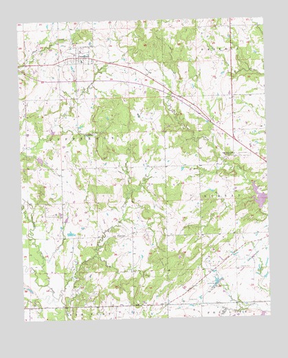
Centrahoma, OK USGS Topographic Map
Click on map above to begin viewing in our Map Viewer.

This topographic map contains these locations and features:
Feature Name Type Latitude Longitude GNIS ID View Map
Caney-Coon Creek Site 1 DamDamN34.5457°W96.2533°1751672View Map
Caney-Coon Creek Site 1 ReservoirReservoirN34.5502°W96.2543°1751673View Map
CentrahomaPopulated PlaceN34.6098°W96.3456°1091185View Map
Centrahoma CemeteryCemeteryN34.6058°W96.3364°2709387View Map
City of CentrahomaCivilN34.6104°W96.3436°2409426View Map
Coal CountyCivilN34.5882°W96.2979°1101802View Map
Hazilton MineMineN34.5140°W96.2775°1093629View Map
Keel CemeteryCemeteryN34.5065°W96.3706°1094302View Map
Keystone MineMineN34.5206°W96.2650°1094361View Map
Leader CreekStreamN34.5151°W96.3631°1094545View Map
Leader Middle Clear Boggy Creek 34 DamDamN34.5784°W96.3592°1751650View Map
Leader Middle Clear Boggy Creek 34 ReservoirReservoirN34.5789°W96.3585°1751651View Map
Leader Middle Clear Boggy Creek 35 DamDamN34.5681°W96.3665°1751698View Map
Leader Middle Clear Boggy Creek 35 ReservoirReservoirN34.5671°W96.3652°1751699View Map
Leader Middle Clear Boggy Creek 36 DamDamN34.5384°W96.3536°1751700View Map
Leader Middle Clear Boggy Creek 6 ReservoirReservoirN34.5384°W96.3536°1751701View Map
Little Caney Boggy CreekStreamN34.5104°W96.3567°1094725View Map
Nixon CemeteryCemeteryN34.5342°W96.3253°2709388View Map
Nixon ChurchChurchN34.5351°W96.3233°1095889View Map
Oak Grove SchoolLocaleN34.5684°W96.2667°1096107View Map
Oconee Oil FieldOilfieldN34.5154°W96.3489°1096173View Map
Phillips MineMineN34.5076°W96.2872°1096605View Map
Round Lake CemeteryCemeteryN34.5779°W96.3375°1097488View Map
Township of JeffersonCivilN34.5765°W96.3558°1824959View Map
Township of MurrayCivilN34.5501°W96.2558°1824962View Map
Tupelo Fire Department Centrahoma StationBuildingN34.6101°W96.3450°2657297View Map

Note: Coordinates in the location and feature list above are referenced to NAD83 datum.


Copyright (C) 2008-2025 Ryan Niemi / Sunset Dynamics ... All Rights Reserved