TopoQuest Logo
Do you find TopoQuest useful?
Help keep TopoQuest running and adding new maps/features by donating!
Bitcoin:  19c7KJd3qBynnjoSw5npx9KScwjBe4ifkT
Litecoin:  LXs6TkuXGGXo1vDsWCkWVdjQX94eUKd6ui
Home View Maps Find Maps Find Places Resources & Links


Central City East, Kentucky Topographic Map

USGS Map Title: Central City East, KY
USGS Map MRC: 37087C1
DRG (GeoTIFF) Download: o37087c1.tif


Neighboring USGS Topographic Map Quads:


  Livermore, KY  
37087D2
 

  Equality, KY  
37087D1
 

  Hartford, KY  
37086D8
 

  Central City West, KY  
37087C2
 

  Central City East, KY  
37087C1
 

  Paradise, KY  
37086C8
 

  Greenville, KY  
37087B2
 

  Drakesboro, KY  
37087B1
 

  Rochester, KY  
37086B8


Map MRC Location:

N38°
W88°
N38°
W87°
H8 H7 H6 H5 H4 H3 H2 H1
G8 G7 G6 G5 G4 G3 G2 G1
F8 F7 F6 F5 F4 F3 F2 F1
E8 E7 E6 E5 E4 E3 E2 E1
D8 D7 D6 D5 D4 D3 D2 D1
C8 C7 C6 C5 C4 C3 C2 C1
B8 B7 B6 B5 B4 B3 B2 B1
A8 A7 A6 A5 A4 A3 A2 A1
N37°
W88°
N37°
W87°

Central City East, KY USGS 1:24K Topographic Map Preview:
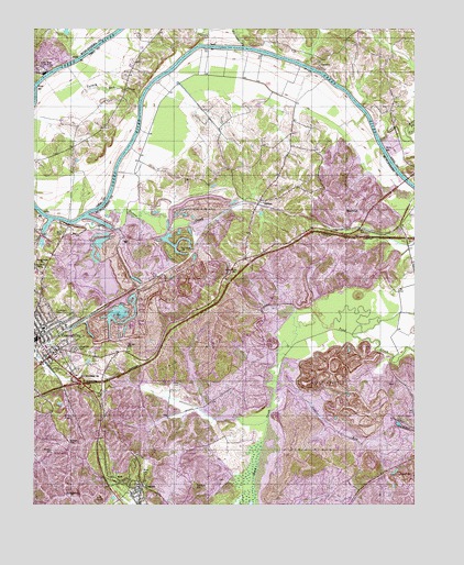
Central City East, KY USGS Topographic Map
Click on map above to begin viewing in our Map Viewer.

This topographic map contains these locations and features:
Feature Name Type Latitude Longitude GNIS ID View Map
Bluff CemeteryCemeteryN37.3211°W87.1153°487566View Map
Brownie (historical)Populated PlaceN37.3274°W87.0012°2742990View Map
Cedardale (historical)Populated PlaceN37.2617°W87.0237°2742992View Map
Central CityPopulated PlaceN37.2939°W87.1233°489282View Map
Central City DivisionCivilN37.3130°W87.1045°1936930View Map
Central City Fire DepartmentBuildingN37.2951°W87.1248°2636633View Map
CeralvoPopulated PlaceN37.3650°W87.0314°507680View Map
CleatonPopulated PlaceN37.2545°W87.0889°489650View Map
Cleaton Census Designated PlaceCensusN37.2516°W87.0902°2629593View Map
Company CemeteryCemeteryN37.2559°W87.0725°489911View Map
Daniel RunStreamN37.2831°W87.0450°490564View Map
Drake (historical)Populated PlaceN37.2603°W87.0800°2743007View Map
Fairmont CemeteryCemeteryN37.2998°W87.1155°491882View Map
Fortney CemeteryCemeteryN37.2639°W87.1186°492361View Map
Green River ChapelChurchN37.3123°W87.1219°493287View Map
Green River Correctional ComplexBuildingN37.3155°W87.1129°2767744View Map
Green River Power PlantLocaleN37.3642°W87.1228°517165View Map
HoltPopulated PlaceN37.2559°W87.0958°494437View Map
Kincheloes BluffCliffN37.3233°W87.1140°2743019View Map
Lewis CreekStreamN37.3462°W87.0111°496327View Map
MartwickPopulated PlaceN37.3270°W87.0239°508550View Map
Miller CemeteryCemeteryN37.2586°W87.0894°498325View Map
Mount Olivet ChurchChurchN37.3175°W87.0767°498804View Map
Mount Zion ChurchChurchN37.2912°W87.0942°498930View Map
NelsonPopulated PlaceN37.3298°W87.0508°499250View Map
Nelson CreekStreamN37.3275°W87.1033°499254View Map
Nelson Creek ChurchChurchN37.3112°W87.0600°499256View Map
Nelson Creek Volunteer Fire DepartmentBuildingN37.3298°W87.0521°2636949View Map
Oakland ChurchChurchN37.2762°W87.0006°499740View Map
Richardson ChapelChurchN37.2517°W87.1092°501805View Map
Rose CemeteryCemeteryN37.2817°W87.0769°502320View Map
Rose Hill CemeteryCemeteryN37.2906°W87.1111°502336View Map
SandhillSummitN37.3291°W87.0368°2743031View Map
Spring Ridge (historical)Populated PlaceN37.3134°W87.1211°2743034View Map
Spring Ridge SchoolSchoolN37.3134°W87.1214°504149View Map
Stewart CemeteryCemeteryN37.2665°W87.1138°504381View Map
StringtownPopulated PlaceN37.2520°W87.1144°504585View Map
Sunnyside (historical)Populated PlaceN37.3599°W87.0773°2743037View Map
Turkey Run CreekStreamN37.3564°W87.0906°505634View Map
West Fork Lewis CreekStreamN37.3492°W87.0022°506436View Map
Williams CreekStreamN37.3706°W87.0550°506816View Map

Note: Coordinates in the location and feature list above are referenced to NAD83 datum.


Copyright (C) 2008-2024 Ryan Niemi / Sunset Dynamics ... All Rights Reserved