TopoQuest Logo
Do you find TopoQuest useful?
Help keep TopoQuest running and adding new maps/features by donating!
Bitcoin:  19c7KJd3qBynnjoSw5npx9KScwjBe4ifkT
Litecoin:  LXs6TkuXGGXo1vDsWCkWVdjQX94eUKd6ui
Home View Maps Find Maps Find Places Resources & Links


Cerro Alesna, New Mexico Topographic Map

USGS Map Title: Cerro Alesna, NM
USGS Map MRC: 35107D5
DRG (GeoTIFF) Download: o35107d5.tif


Neighboring USGS Topographic Map Quads:


  Piedra De La Aguila, NM  
35107E6
 

  El Dado, NM  
35107E5
 

  Mesa Cortada, NM  
35107E4
 

  San Lucas Dam, NM  
35107D6
 

  Cerro Alesna, NM  
35107D5
 

  El Dado Mesa, NM  
35107D4
 

  San Mateo, NM  
35107C6
 

  Cerro Pelon, NM  
35107C5
 

  Laguna Canoneros, NM  
35107C4


Map MRC Location:

N36°
W108°
N36°
W107°
H8 H7 H6 H5 H4 H3 H2 H1
G8 G7 G6 G5 G4 G3 G2 G1
F8 F7 F6 F5 F4 F3 F2 F1
E8 E7 E6 E5 E4 E3 E2 E1
D8 D7 D6 D5 D4 D3 D2 D1
C8 C7 C6 C5 C4 C3 C2 C1
B8 B7 B6 B5 B4 B3 B2 B1
A8 A7 A6 A5 A4 A3 A2 A1
N35°
W108°
N35°
W107°

Cerro Alesna, NM USGS 1:24K Topographic Map Preview:
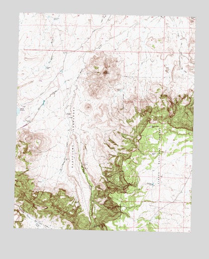
Cerro Alesna, NM USGS Topographic Map
Click on map above to begin viewing in our Map Viewer.

This topographic map contains these locations and features:
Feature Name Type Latitude Longitude GNIS ID View Map
Alesna TankReservoirN35.4563°W107.5520°903070View Map
Bartolome Fernandez GrantCivilN35.4289°W107.5856°903592View Map
Boulder TankReservoirN35.4200°W107.5298°904026View Map
Cerro AlesnaSummitN35.4664°W107.5637°904946View Map
Cerro SpringSpringN35.4492°W107.5726°917575View Map
Colorado CanyonValleyN35.3792°W107.6106°905264View Map
El Dado PeakSummitN35.4973°W107.5034°888808View Map
Fort Miguel Ruins SpringSpringN35.4109°W107.5770°920109View Map
Hoot Owl TankReservoirN35.4024°W107.5282°907076View Map
Las Yeguas CanyonValleyN35.4470°W107.5876°907885View Map
Los Barreales LakeLakeN35.4359°W107.5304°908197View Map
Rincon del DadoValleyN35.4789°W107.5112°910184View Map
San Isidro SpringSpringN35.4967°W107.6016°910631View Map
San Lucas CanyonValleyN35.4648°W107.5823°910654View Map
San Lucas SpringSpringN35.4367°W107.6154°910657View Map
San Lucas ValleyValleyN35.3806°W107.6131°910658View Map
San Miguel CanyonValleyN35.4575°W107.5839°910674View Map
San Miguel RanchLocaleN35.4414°W107.5878°910691View Map
San Miguel SpringSpringN35.3773°W107.5692°910692View Map
Sap Hole SpringSpringN35.4154°W107.5905°920108View Map
Telesfors TankReservoirN35.4682°W107.6060°911597View Map
Television TankReservoirN35.4601°W107.6107°911598View Map

Note: Coordinates in the location and feature list above are referenced to NAD83 datum.


Copyright (C) 2008-2025 Ryan Niemi / Sunset Dynamics ... All Rights Reserved