TopoQuest Logo
Do you find TopoQuest useful?
Help keep TopoQuest running and adding new maps/features by donating!
Bitcoin:  19c7KJd3qBynnjoSw5npx9KScwjBe4ifkT
Litecoin:  LXs6TkuXGGXo1vDsWCkWVdjQX94eUKd6ui
Home View Maps Find Maps Find Places Resources & Links


Chama, New Mexico Topographic Map

USGS Map Title: Chama, NM
USGS Map MRC: 36106H5
DRG (GeoTIFF) Download: o36106h5.tif


Neighboring USGS Topographic Map Quads:


  Chama Peak, CO  
37106A6
 

  Archuleta Creek, CO  
37106A5
 

  Cumbres, CO  
37106A4
 

  Chromo Mountain, NM  
36106H6
 

  Chama, NM  
36106H5
 

  West Fork Rio Brazos, NM  
36106H4
 

  Sawmill Mesa, NM  
36106G6
 

  Brazos, NM  
36106G5
 

  Brazos Peak, NM  
36106G4


Map MRC Location:

N37°
W107°
N37°
W106°
H8 H7 H6 H5 H4 H3 H2 H1
G8 G7 G6 G5 G4 G3 G2 G1
F8 F7 F6 F5 F4 F3 F2 F1
E8 E7 E6 E5 E4 E3 E2 E1
D8 D7 D6 D5 D4 D3 D2 D1
C8 C7 C6 C5 C4 C3 C2 C1
B8 B7 B6 B5 B4 B3 B2 B1
A8 A7 A6 A5 A4 A3 A2 A1
N36°
W107°
N36°
W106°

Chama, NM USGS 1:24K Topographic Map Preview:
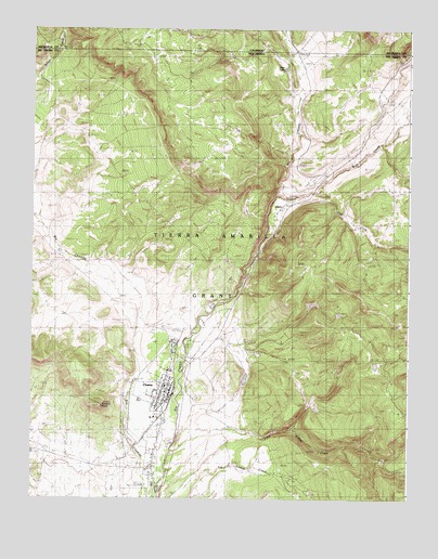
Chama, NM USGS Topographic Map
Click on map above to begin viewing in our Map Viewer.

This topographic map contains these locations and features:
Feature Name Type Latitude Longitude GNIS ID View Map
Burns-Kelly Store Historic SiteBuildingN36.9031°W106.5795°933481View Map
ChamaPopulated PlaceN36.9031°W106.5795°902207View Map
Chama CemeteryCemeteryN36.9014°W106.5702°887414View Map
Chama Church of ChristChurchN36.9031°W106.5795°920504View Map
Chama Elementary SchoolSchoolN36.9031°W106.5795°934138View Map
Chama Historical MarkerParkN36.9031°W106.5795°932273View Map
Chama Jail House Historic SiteBuildingN36.9031°W106.5795°933809View Map
Chama Land & Cattle Company AirportAirportN36.8756°W106.5765°936919View Map
Chama Police DepartmentBuildingN36.9045°W106.5801°2722618View Map
Chama Post OfficePost OfficeN36.9033°W106.5801°937985View Map
Chama Volunteer Fire DepartmentBuildingN36.9045°W106.5802°2657748View Map
Chama Weather StationLocaleN36.9031°W106.5795°932547View Map
Cumbres and Toltec Scenic RailroadLocaleN36.9031°W106.5795°935680View Map
Cumbres and Toltec Scenic Railroad Historical MarkerParkN36.9031°W106.5795°932233View Map
Cumbres Pass Historical MarkerParkN36.9031°W106.5795°932272View Map
Doctor J I Dunham Memorial ClinicHospitalN36.9031°W106.5795°939210View Map
Dunham Log House Historic SiteBuildingN36.9031°W106.5795°933587View Map
East Fork Wolf CreekStreamN36.9564°W106.5306°905974View Map
Eastside AirportAirportN36.9212°W106.5608°2444039View Map
Eleanor Daggett Memorial LibraryBuildingN36.9031°W106.5795°929380View Map
First Baptist ChurchChurchN36.9031°W106.5795°920453View Map
Foster Hotel Historic SiteBuildingN36.9031°W106.5795°933423View Map
Kays LakeReservoirN36.9896°W106.5417°1945984View Map
Little Willow CreekStreamN36.8875°W106.5795°908071View Map
LobatoPopulated PlaceN36.9542°W106.5414°898568View Map
M B DitchCanalN36.8895°W106.6148°891512View Map
Rabbit PeakSummitN36.8997°W106.6014°893599View Map
Valley Gospel Fellowship ChurchChurchN36.9031°W106.5795°919465View Map
Village of ChamaCivilN36.8926°W106.5843°2413539View Map
Water Well 3WellN36.8928°W106.5789°926498View Map
Wolf CreekStreamN36.9560°W106.5446°190871View Map

Note: Coordinates in the location and feature list above are referenced to NAD83 datum.


Copyright (C) 2008-2025 Ryan Niemi / Sunset Dynamics ... All Rights Reserved