TopoQuest Logo
Do you find TopoQuest useful?
Help keep TopoQuest running and adding new maps/features by donating!
Bitcoin:  19c7KJd3qBynnjoSw5npx9KScwjBe4ifkT
Litecoin:  LXs6TkuXGGXo1vDsWCkWVdjQX94eUKd6ui
Home View Maps Find Maps Find Places Resources & Links


Chavez Mountain East, Arizona Topographic Map

USGS Map Title: Chavez Mountain East, AZ
USGS Map MRC: 34111G1
DRG (GeoTIFF) Download: o34111g1.tif


Neighboring USGS Topographic Map Quads:


  Chavez Mountain NW, AZ  
34111H2
 

  Chavez Mountain NE, AZ  
34111H1
 

  West Sunset Mountain, AZ  
34110H8
 

  Chavez Mountain West, AZ  
34111G2
 

  Chavez Mountain East, AZ  
34111G1
 

  Sunset Pass, AZ  
34110G8
 

  Hay Lake, AZ  
34111F2
 

  Quayle Hill, AZ  
34111F1
 

  Hamilton Crossing, AZ  
34110F8


Map MRC Location:

N35°
W112°
N35°
W111°
H8 H7 H6 H5 H4 H3 H2 H1
G8 G7 G6 G5 G4 G3 G2 G1
F8 F7 F6 F5 F4 F3 F2 F1
E8 E7 E6 E5 E4 E3 E2 E1
D8 D7 D6 D5 D4 D3 D2 D1
C8 C7 C6 C5 C4 C3 C2 C1
B8 B7 B6 B5 B4 B3 B2 B1
A8 A7 A6 A5 A4 A3 A2 A1
N34°
W112°
N34°
W111°

Chavez Mountain East, AZ USGS 1:24K Topographic Map Preview:
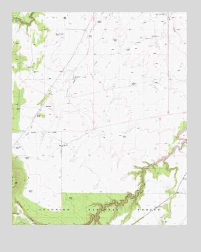
Chavez Mountain East, AZ USGS Topographic Map
Click on map above to begin viewing in our Map Viewer.

This topographic map contains these locations and features:
Feature Name Type Latitude Longitude GNIS ID View Map
Bypass TankReservoirN34.8178°W111.1222°27121View Map
Chavez Draw TankReservoirN34.7566°W111.1197°27528View Map
Chavez MountainSummitN34.7747°W111.1235°27529View Map
Chavez Pass DitchCanalN34.8372°W111.0724°27531View Map
Deep WellWellN34.7970°W111.0896°28369View Map
Fourteen Inch TankReservoirN34.8530°W111.0441°29151View Map
Goslin TankReservoirN34.8692°W111.0647°29426View Map
Hart TankReservoirN34.7521°W111.0191°29774View Map
Horse Pasture TankReservoirN34.8617°W111.0944°30164View Map
Lute Hart TankReservoirN34.7958°W111.1232°31406View Map
Melbourne DamDamN34.8397°W111.1115°31708View Map
Melburn TankReservoirN34.8394°W111.1117°37935View Map
Mud TankReservoirN34.8715°W111.0891°32143View Map
New TankReservoirN34.8608°W111.0214°32303View Map
Pat Duke TankReservoirN34.8366°W111.0812°32715View Map
Perkins TanksReservoirN34.8143°W111.1083°32800View Map
Pieper TankReservoirN34.8587°W111.0532°32876View Map
Pollack TankReservoirN34.8321°W111.0406°33089View Map
Pyeatt TankReservoirN34.8019°W111.0469°33242View Map
Red TankReservoirN34.8190°W111.1011°33520View Map
Service TankReservoirN34.7698°W111.1138°41903View Map
Small TankReservoirN34.7653°W111.0848°34541View Map
State Antelope TrapLocaleN34.8011°W111.0943°41902View Map
Twin TanksReservoirN34.8603°W111.0714°35633View Map
Upper Dog Valley TankReservoirN34.8736°W111.0160°35682View Map
Windy TankReservoirN34.7893°W111.1161°36315View Map

Note: Coordinates in the location and feature list above are referenced to NAD83 datum.


Copyright (C) 2008-2025 Ryan Niemi / Sunset Dynamics ... All Rights Reserved