TopoQuest Logo
Do you find TopoQuest useful?
Help keep TopoQuest running and adding new maps/features by donating!
Bitcoin:  19c7KJd3qBynnjoSw5npx9KScwjBe4ifkT
Litecoin:  LXs6TkuXGGXo1vDsWCkWVdjQX94eUKd6ui
Home View Maps Find Maps Find Places Resources & Links


Chesser Island, Georgia Topographic Map

USGS Map Title: Chesser Island, GA
USGS Map MRC: 30082F2
DRG (GeoTIFF) Download: o30082f2.tif


Neighboring USGS Topographic Map Quads:


  Billys Island, GA  
30082G3
 

  Chase Prairie, GA  
30082G2
 

  Folkston, GA  
30082G1
 

  Blackjack Island, GA  
30082F3
 

  Chesser Island, GA  
30082F2
 

  Toledo, GA  
30082F1
 

  Eddy, FL  
30082E3
 

  Moniac, GA  
30082E2
 

  Saint George, GA  
30082E1


Map MRC Location:

N31°
W83°
N31°
W82°
H8 H7 H6 H5 H4 H3 H2 H1
G8 G7 G6 G5 G4 G3 G2 G1
F8 F7 F6 F5 F4 F3 F2 F1
E8 E7 E6 E5 E4 E3 E2 E1
D8 D7 D6 D5 D4 D3 D2 D1
C8 C7 C6 C5 C4 C3 C2 C1
B8 B7 B6 B5 B4 B3 B2 B1
A8 A7 A6 A5 A4 A3 A2 A1
N30°
W83°
N30°
W82°

Chesser Island, GA USGS 1:24K Topographic Map Preview:
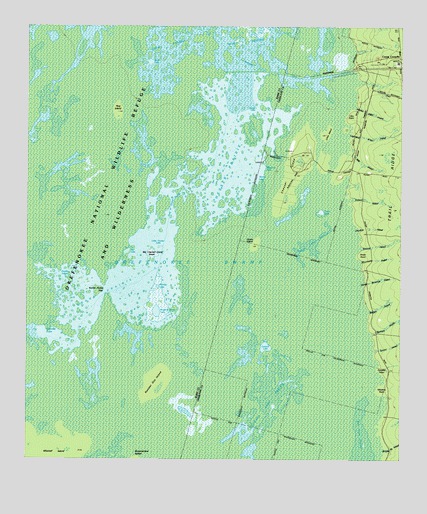
Chesser Island, GA USGS Topographic Map
Click on map above to begin viewing in our Map Viewer.

This topographic map contains these locations and features:
Feature Name Type Latitude Longitude GNIS ID View Map
Big Cypress Camp IslandIslandN30.6822°W82.2090°311374View Map
Big Cypress LakeLakeN30.6838°W82.2087°311376View Map
Buck LakeLakeN30.7330°W82.2032°311970View Map
Buck PrairieSwampN30.7436°W82.2029°311973View Map
Burnett LakeLakeN30.7069°W82.1760°1705500View Map
Buzzards Roost LakeLakeN30.6679°W82.2064°312125View Map
Camp CorneliaLocaleN30.7402°W82.1273°312207View Map
Charles IslandIslandN30.6997°W82.2226°312575View Map
Chesser IslandIslandN30.7066°W82.1623°312622View Map
Chesser PrairieSwampN30.7077°W82.1840°312623View Map
Chesser School (historical)SchoolN30.7069°W82.1276°334134View Map
Cooter LakeLakeN30.7263°W82.1735°312955View Map
Coward LakeLakeN30.6577°W82.1699°313057View Map
Coward Lake PrairieSwampN30.6433°W82.1648°313058View Map
Double LakeLakeN30.6777°W82.2376°313576View Map
Gannet LakeLakeN30.6627°W82.2440°314505View Map
Goose House GapGapN30.6741°W82.2232°314700View Map
Grand PrairieSwampN30.6725°W82.2215°314768View Map
Hog IslandIslandN30.7252°W82.2198°315509View Map
Horse IslandIslandN30.6872°W82.1740°315695View Map
Little Cooter LakeLakeN30.6880°W82.2054°316996View Map
Little IslandIslandN30.7191°W82.1504°317099View Map
Mitchell IslandIslandN30.6277°W82.2385°318347View Map
Monkey LakeLakeN30.6751°W82.2061°318395View Map
Number One IslandIslandN30.6472°W82.2062°319719View Map
Seagrove LakeLakeN30.7088°W82.1715°322677View Map
Stump LakeLakeN30.7066°W82.1732°323710View Map
Suwannee Canal Recreation AreaParkN30.7400°W82.1271°357794View Map
Tar LakeLakeN30.6847°W82.2165°323919View Map
Trout LakeLakeN30.6968°W82.1514°324335View Map
Trout Lake PrairieSwampN30.6880°W82.1529°324338View Map

Note: Coordinates in the location and feature list above are referenced to NAD83 datum.


Copyright (C) 2008-2025 Ryan Niemi / Sunset Dynamics ... All Rights Reserved