TopoQuest Logo
Do you find TopoQuest useful?
Help keep TopoQuest running and adding new maps/features by donating!
Bitcoin:  19c7KJd3qBynnjoSw5npx9KScwjBe4ifkT
Litecoin:  LXs6TkuXGGXo1vDsWCkWVdjQX94eUKd6ui
Home View Maps Find Maps Find Places Resources & Links


Chimney Rock, Utah Topographic Map

USGS Map Title: Chimney Rock, UT
USGS Map MRC: 39110B5
DRG (GeoTIFF) Download: o39110b5.tif


Neighboring USGS Topographic Map Quads:


  Cow Flats, UT  
39110C6
 

  Flattop Mountain, UT  
39110C5
 

  Grassy, UT  
39110C4
 

  Bob Hill Knoll, UT  
39110B6
 

  Chimney Rock, UT  
39110B5
 

  Dry Mesa, UT  
39110B4
 

  Bottleneck Peak, UT  
39110A6
 

  Devils Hole, UT  
39110A5
 

  Mexican Mountain, UT  
39110A4


Map MRC Location:

N40°
W111°
N40°
W110°
H8 H7 H6 H5 H4 H3 H2 H1
G8 G7 G6 G5 G4 G3 G2 G1
F8 F7 F6 F5 F4 F3 F2 F1
E8 E7 E6 E5 E4 E3 E2 E1
D8 D7 D6 D5 D4 D3 D2 D1
C8 C7 C6 C5 C4 C3 C2 C1
B8 B7 B6 B5 B4 B3 B2 B1
A8 A7 A6 A5 A4 A3 A2 A1
N39°
W111°
N39°
W110°

Chimney Rock, UT USGS 1:24K Topographic Map Preview:
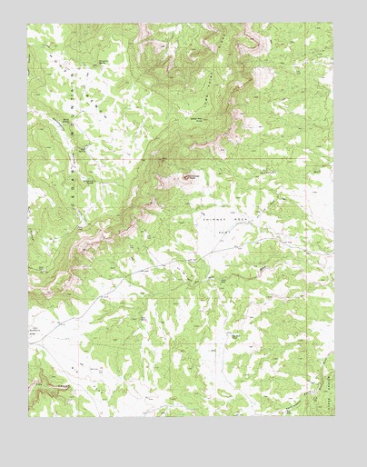
Chimney Rock, UT USGS Topographic Map
Click on map above to begin viewing in our Map Viewer.

This topographic map contains these locations and features:
Feature Name Type Latitude Longitude GNIS ID View Map
Big FlatFlatN39.1272°W110.5943°1425488View Map
Big HoleLakeN39.1264°W110.5207°1425499View Map
Big Hole PondLakeN39.1512°W110.5424°1425500View Map
Birch SpringSpringN39.2183°W110.6085°1425616View Map
Cedar MountainSummitN39.1714°W110.6188°1426466View Map
Cedar Mountain CampgroundLocaleN39.1666°W110.6213°1435283View Map
Cedar Mountain KnollSummitN39.2191°W110.5540°1450291View Map
Cedar Mountain Recreation AreaParkN39.1666°W110.6210°1435282View Map
Cedar MountainsRangeN39.2191°W110.5535°1426467View Map
Chimney RockPillarN39.2008°W110.5608°2413969View Map
Chimney RockSummitN39.2011°W110.5599°1426580View Map
Chimney Rock FlatSummitN39.1864°W110.5396°1426591View Map
Gooseberry SpringSpringN39.1998°W110.5983°1428261View Map
Huff BenchBenchN39.2364°W110.6079°1428933View Map
Huff SpringSpringN39.2105°W110.6021°1428935View Map
Joes HolesLakeN39.1555°W110.5799°1429192View Map
Lews HoleLakeN39.1686°W110.5465°1429601View Map
Long Point RidgeRidgeN39.2405°W110.5452°1429915View Map
Pack Saddle GulchValleyN39.1322°W110.5093°1431064View Map
Point of Cedar MountainCliffN39.1622°W110.6204°1455465View Map
Wiregrass SpringSpringN39.2368°W110.5962°1434425View Map

Note: Coordinates in the location and feature list above are referenced to NAD83 datum.


Copyright (C) 2008-2025 Ryan Niemi / Sunset Dynamics ... All Rights Reserved