TopoQuest Logo
Do you find TopoQuest useful?
Help keep TopoQuest running and adding new maps/features by donating!
Bitcoin:  19c7KJd3qBynnjoSw5npx9KScwjBe4ifkT
Litecoin:  LXs6TkuXGGXo1vDsWCkWVdjQX94eUKd6ui
Home View Maps Find Maps Find Places Resources & Links


Clark Center, Illinois Topographic Map

USGS Map Title: Clark Center, IL
USGS Map MRC: 39087C7
DRG (GeoTIFF) Download: o39087c7.tif


Neighboring USGS Topographic Map Quads:


  Westfield East, IL  
39087D8
 

  Clarksville, IL  
39087D7
 

  Marshall, IL  
39087D6
 

  Casey, IL  
39087C8
 

  Clark Center, IL  
39087C7
 

  Snyder, IL  
39087C6
 

  Moriah, IL  
39087B8
 

  Annapolis, IL  
39087B7
 

  West Union, IL  
39087B6


Map MRC Location:

N40°
W88°
N40°
W87°
H8 H7 H6 H5 H4 H3 H2 H1
G8 G7 G6 G5 G4 G3 G2 G1
F8 F7 F6 F5 F4 F3 F2 F1
E8 E7 E6 E5 E4 E3 E2 E1
D8 D7 D6 D5 D4 D3 D2 D1
C8 C7 C6 C5 C4 C3 C2 C1
B8 B7 B6 B5 B4 B3 B2 B1
A8 A7 A6 A5 A4 A3 A2 A1
N39°
W88°
N39°
W87°

Clark Center, IL USGS 1:24K Topographic Map Preview:
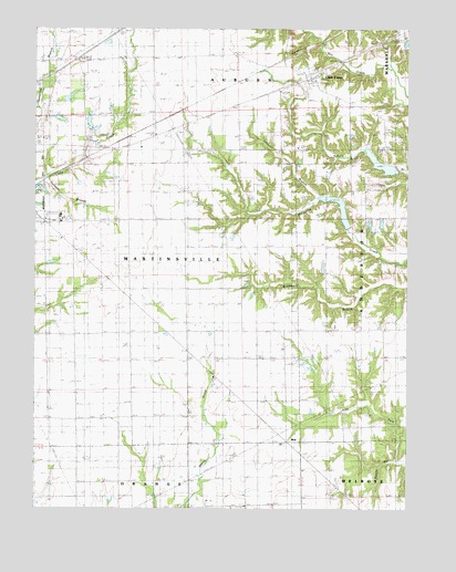
Clark Center, IL USGS Topographic Map
Click on map above to begin viewing in our Map Viewer.

This topographic map contains these locations and features:
Feature Name Type Latitude Longitude GNIS ID View Map
AdenmoorPopulated PlaceN39.3659°W87.7967°422414View Map
Auburn CemeteryCemeteryN39.3649°W87.7822°2745653View Map
Baird-Barr CemeteryCemeteryN39.2955°W87.8742°1922865View Map
Bethel School (historical)SchoolN39.3503°W87.8220°404320View Map
Clark CenterPopulated PlaceN39.3625°W87.7820°406157View Map
Clark CountyCivilN39.3336°W87.7877°424213View Map
Five Points Christian ChurchChurchN39.3675°W87.8075°408418View Map
Freedom Baptist ChurchChurchN39.3328°W87.7639°1785482View Map
Freedom School (historical)SchoolN39.3317°W87.7639°408720View Map
Frog Pond School (historical)SchoolN39.2875°W87.8717°408773View Map
Island Grove CemeteryCemeteryN39.2756°W87.8225°1922927View Map
Island Grove ChurchChurchN39.2764°W87.8228°410962View Map
Jackson School (historical)SchoolN39.2886°W87.7586°411003View Map
Jeff Davis School (historical)SchoolN39.3695°W87.8175°411047View Map
Johnson BranchStreamN39.3309°W87.7795°411146View Map
Mill Creek Watershed Impoundment ReservoirReservoirN39.3400°W87.7590°1692192View Map
Mill Creek Watershed Impoundment ReservoirReservoirN39.3275°W87.7718°1692194View Map
Mill Creek Watershed Structure Number 6 DamDamN39.3350°W87.7517°1692191View Map
Mill Creek Watershed Structure Number 7 DamDamN39.3217°W87.7684°1692193View Map
Mount Pleasant CemeteryCemeteryN39.3098°W87.8047°1922961View Map
Mount Pleasant ChurchChurchN39.3120°W87.8028°414057View Map
Newmans LakeReservoirN39.3570°W87.8637°1692033View Map
Newmans Lake DamDamN39.3567°W87.8667°1692032View Map
Norman BranchStreamN39.3350°W87.8720°414549View Map
Norton CemeteryCemeteryN39.3150°W87.7592°1922963View Map
Possum Ridge School (historical)SchoolN39.3195°W87.7781°416064View Map
Prairie School (historical)SchoolN39.2886°W87.8139°416156View Map
Rocky HollowValleyN39.2627°W87.7534°416881View Map
Saint Paul ChurchChurchN39.2698°W87.8148°417702View Map
School Number 1 (historical)SchoolN39.3250°W87.8206°425454View Map
Shiloh Church (historical)ChurchN39.2945°W87.8620°418416View Map
Township of AuburnCivilN39.3687°W87.8074°428618View Map
Township of MartinsvilleCivilN39.3207°W87.8509°429333View Map
WeirPopulated PlaceN39.2678°W87.7903°1736471View Map
WMMC-FM (Marshall)TowerN39.3606°W87.7920°428238View Map
Woodlawn School (historical)SchoolN39.3361°W87.7909°421460View Map

Note: Coordinates in the location and feature list above are referenced to NAD83 datum.


Copyright (C) 2008-2025 Ryan Niemi / Sunset Dynamics ... All Rights Reserved