TopoQuest Logo
Do you find TopoQuest useful?
Help keep TopoQuest running and adding new maps/features by donating!
Bitcoin:  19c7KJd3qBynnjoSw5npx9KScwjBe4ifkT
Litecoin:  LXs6TkuXGGXo1vDsWCkWVdjQX94eUKd6ui
Home View Maps Find Maps Find Places Resources & Links


Clarno, Oregon Topographic Map

USGS Map Title: Clarno, OR
USGS Map MRC: 44120H4
DRG (GeoTIFF) Download: o44120h4.tif


Neighboring USGS Topographic Map Quads:


  Bath Canyon, OR  
45120A5
 

  Chimney Springs, OR  
45120A4
 

  Buckhorn Canyon, OR  
45120A3
 

  Hastings Peak, OR  
44120H5
 

  Clarno, OR  
44120H4
 

  Porcupine Butte, OR  
44120H3
 

  Arrastra Butte, OR  
44120G5
 

  Muddy Ranch, OR  
44120G4
 

  Jennies Peak, OR  
44120G3


Map MRC Location:

N45°
W121°
N45°
W120°
H8 H7 H6 H5 H4 H3 H2 H1
G8 G7 G6 G5 G4 G3 G2 G1
F8 F7 F6 F5 F4 F3 F2 F1
E8 E7 E6 E5 E4 E3 E2 E1
D8 D7 D6 D5 D4 D3 D2 D1
C8 C7 C6 C5 C4 C3 C2 C1
B8 B7 B6 B5 B4 B3 B2 B1
A8 A7 A6 A5 A4 A3 A2 A1
N44°
W121°
N44°
W120°

Clarno, OR USGS 1:24K Topographic Map Preview:
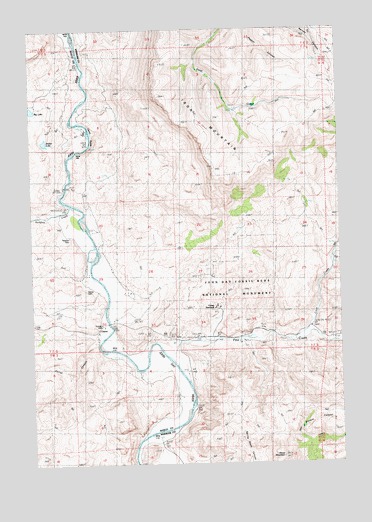
Clarno, OR USGS Topographic Map
Click on map above to begin viewing in our Map Viewer.

This topographic map contains these locations and features:
Feature Name Type Latitude Longitude GNIS ID View Map
Black SpurRidgeN44.9249°W120.4275°1891233View Map
Camp HancockLocaleN44.9196°W120.4259°1118518View Map
ClarnoPopulated PlaceN44.9135°W120.4734°1136154View Map
Clarno CemeteryCemeteryN44.9247°W120.4791°1118979View Map
Clarno Post Office (historical)Post OfficeN44.9135°W120.4734°1165056View Map
Clarno RapidsRapidsN44.9715°W120.4772°1161681View Map
Clarno State Recreation Site Boat LaunchLocaleN44.9161°W120.4698°2700049View Map
Claron ArchArchN44.9121°W120.4173°1679038View Map
Corral CanyonValleyN44.9101°W120.4739°1119291View Map
Cove CreekStreamN44.9107°W120.3970°1119410View Map
Crown Rock (historical)LocaleN44.9110°W120.4261°1132002View Map
Crown Rock Post Office (historical)Post OfficeN44.9110°W120.4261°1165117View Map
Equisetum CanyonValleyN44.9182°W120.4211°1891230View Map
Francisville Post Office (historical)Post OfficeN44.9151°W120.3873°1165277View Map
Hancock CanyonValleyN44.9121°W120.4278°1121548View Map
Horse MountainSummitN44.8771°W120.4009°1122011View Map
Huntley Post Office (historical)Post OfficeN44.9068°W120.4456°1164426View Map
Indian CanyonValleyN44.9129°W120.4098°1122200View Map
Iron MountainRidgeN44.9679°W120.4303°1122272View Map
Lower Pine Creek School (historical)SchoolN44.9146°W120.3881°1123578View Map
Pine CreekStreamN44.9060°W120.4467°1125396View Map
Red HillSummitN44.9215°W120.4339°1891229View Map
Rotten LakeLakeN44.9677°W120.4951°1126314View Map
Sorefoot CreekStreamN44.9501°W120.4850°1127213View Map
The PalisadesCliffN44.9124°W120.4175°1127992View Map
Tillotson CemeteryCemeteryN44.9405°W120.4855°1128097View Map
Whitecap KnollSummitN44.9360°W120.4189°1891232View Map
Willow BranchStreamN44.9471°W120.4789°1132005View Map
Willow Branch SpringSpringN44.9518°W120.4734°1132004View Map

Note: Coordinates in the location and feature list above are referenced to NAD83 datum.


Copyright (C) 2008-2024 Ryan Niemi / Sunset Dynamics ... All Rights Reserved