TopoQuest Logo
Do you find TopoQuest useful?
Help keep TopoQuest running and adding new maps/features by donating!
Bitcoin:  19c7KJd3qBynnjoSw5npx9KScwjBe4ifkT
Litecoin:  LXs6TkuXGGXo1vDsWCkWVdjQX94eUKd6ui
Home View Maps Find Maps Find Places Resources & Links


Clayville, Rhode Island Topographic Map

USGS Map Title: Clayville, RI
USGS Map MRC: 41071G6
DRG (GeoTIFF) Download: o41071g6.tif


Neighboring USGS Topographic Map Quads:


  Thompson, CT  
41071H7
 

  Chepachet, RI  
41071H6
 

  Georgiaville, RI  
41071H5
 

  East Killingly, CT  
41071G7
 

  Clayville, RI  
41071G6
 

  North Scituate, RI  
41071G5
 

  Oneco, CT  
41071F7
 

  Coventry Center, RI  
41071F6
 

  Crompton, RI  
41071F5


Map MRC Location:

N42°
W72°
N42°
W71°
H8 H7 H6 H5 H4 H3 H2 H1
G8 G7 G6 G5 G4 G3 G2 G1
F8 F7 F6 F5 F4 F3 F2 F1
E8 E7 E6 E5 E4 E3 E2 E1
D8 D7 D6 D5 D4 D3 D2 D1
C8 C7 C6 C5 C4 C3 C2 C1
B8 B7 B6 B5 B4 B3 B2 B1
A8 A7 A6 A5 A4 A3 A2 A1
N41°
W72°
N41°
W71°

Clayville, RI USGS 1:24K Topographic Map Preview:
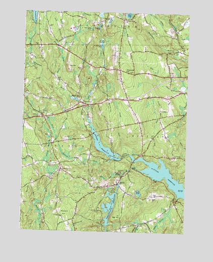
Clayville, RI USGS Topographic Map
Click on map above to begin viewing in our Map Viewer.

This topographic map contains these locations and features:
Feature Name Type Latitude Longitude GNIS ID View Map
Allan Richard BrookStreamN41.8576°W71.7192°1218605View Map
Barden ReservoirReservoirN41.7970°W71.6876°1218586View Map
Barden Reservoir DamDamN41.7920°W71.6740°1219164View Map
Bear Tree BrookStreamN41.7823°W71.6734°1218579View Map
Bennett HillSummitN41.7762°W71.7437°1218583View Map
Big HillSummitN41.7590°W71.6748°1218574View Map
Brush Meadow SwampSwampN41.8574°W71.6911°1219392View Map
Captain Isaac Paine SchoolSchoolN41.8134°W71.7328°1903244View Map
Charles Phillips Lot CemeteryCemeteryN41.7887°W71.7012°1903985View Map
Cherry ValleyPopulated PlaceN41.8709°W71.6745°1219544View Map
Cherry Valley PondReservoirN41.8736°W71.6713°1218600View Map
Cherry Valley Pond DamDamN41.8737°W71.6723°1219204View Map
ChopmistPopulated PlaceN41.8254°W71.6703°1220021View Map
Chopmist Fire Lookout StationTowerN41.8432°W71.6703°1903285View Map
Chopmist HillSummitN41.8412°W71.6701°1218598View Map
Chopmist Hill Fire DepartmentBuildingN41.8159°W71.6625°2475243View Map
ClayvillePopulated PlaceN41.7779°W71.6756°1218580View Map
Clayville Census Designated PlaceCensusN41.7734°W71.6853°2631331View Map
Clayville ChurchChurchN41.7768°W71.6792°1903316View Map
Clayville Elementary SchoolSchoolN41.7723°W71.6709°1903317View Map
Clayville Historic DistrictParkN41.7773°W71.6773°1903318View Map
Clayville Post OfficePost OfficeN41.7743°W71.6726°2475575View Map
Colonel Nathaniel Stone Lot CemeteryCemeteryN41.8038°W71.7157°1904320View Map
Cork BrookStreamN41.7923°W71.6451°1218589View Map
Crazy CornersLocaleN41.7940°W71.6590°1218588View Map
Daniel Howard LotCemeteryN41.7588°W71.7199°1903936View Map
Dolly Cole BrookStreamN41.8159°W71.6998°1218591View Map
Field HillSummitN41.7690°W71.6503°1218576View Map
Foster Ambulance CorpsBuildingN41.8213°W71.7444°2662457View Map
Foster CenterPopulated PlaceN41.7851°W71.7195°1218582View Map
Foster Center Census Designated PlaceCensusN41.7898°W71.7327°2631333View Map
Foster Center Fire DepartmentBuildingN41.7849°W71.7194°2475296View Map
Foster Center Historic DistrictParkN41.7854°W71.7201°1903496View Map
Foster Police DepartmentBuildingN41.7842°W71.7206°2475297View Map
Foster Post OfficePost OfficeN41.7844°W71.7170°1903497View Map
Foster Public LibraryBuildingN41.7846°W71.7205°2475298View Map
Foster Town HallBuildingN41.7845°W71.7209°1903498View Map
Hannah BrookStreamN41.8515°W71.7217°1218606View Map
Hemlock BrookStreamN41.7907°W71.6828°1218581View Map
Hopkins Mill Historic DistrictParkN41.8237°W71.7070°1903645View Map
Hopkins Mill Pond DamDamN41.8251°W71.7092°1219174View Map
Hopkins MillsPopulated PlaceN41.8223°W71.7028°1219329View Map
Hopkins Mills Lot CemeteryCemeteryN41.8210°W71.7038°1903646View Map
Hopkins Mills PondReservoirN41.8254°W71.7099°1218593View Map
Howard HillSummitN41.7604°W71.7165°1218573View Map
Keech PondReservoirN41.8234°W71.7078°1219171View Map
Keech Pond DamDamN41.8234°W71.7078°1219172View Map
Killy BrookStreamN41.8515°W71.7217°1218599View Map
King PondLakeN41.7723°W71.6605°1218608View Map
Mill Pond DamDamN41.7634°W71.6762°604366View Map
New Rockland CemeteryCemeteryN41.7843°W71.6753°1903902View Map
Oak HillSummitN41.8437°W71.7151°1218596View Map
Paine BrookStreamN41.8048°W71.7242°1218585View Map
Peckham BrookStreamN41.8737°W71.6915°1218603View Map
Peckham PondLakeN41.8664°W71.6934°1218602View Map
Phillips Memorial CemeteryCemeteryN41.7881°W71.7288°1903986View Map
Ponaganset (historical)Populated PlaceN41.7932°W71.6731°1219838View Map
Ponaganset High SchoolSchoolN41.8654°W71.7128°1904002View Map
Ponaganset Middle SchoolSchoolN41.8659°W71.7153°1904003View Map
Ponaganset Reservoir DamDamN41.8684°W71.7428°1219198View Map
Ponaganset RiverStreamN41.7934°W71.6678°1218587View Map
Ponagansett BridgeBridgeN41.7929°W71.6740°1904004View Map
Ponagansett Public Fishing AreaLocaleN41.8454°W71.7423°1904005View Map
Potterville BrookStreamN41.7554°W71.6576°1218575View Map
Potterville Fire DepartmentBuildingN41.7656°W71.6316°2475421View Map
Pray HillSummitN41.8562°W71.7387°1218607View Map
Rockland (historical)Populated PlaceN41.7870°W71.6667°1219335View Map
Round HillSummitN41.8204°W71.6826°1218590View Map
Saint Timothy ChurchChurchN41.7929°W71.6345°1904222View Map
Sand Hill CemeteryCemeteryN41.7823°W71.7249°1904228View Map
Schwindel SwampSwampN41.8704°W71.6851°1218601View Map
Scituate Ambulance and Rescue CorpsBuildingN41.8256°W71.6662°2662451View Map
Scituate Early Learning CenterBuildingN41.8391°W71.6332°2475443View Map
Shippee BrookStreamN41.8348°W71.7351°1218595View Map
Simmons CornerPopulated PlaceN41.8151°W71.7340°1219543View Map
South FosterPopulated PlaceN41.8229°W71.7037°1218592View Map
South Volunteer Foster Fire CompanyBuildingN41.8163°W71.7362°2475450View Map
Spear PondLakeN41.8034°W71.7300°1218584View Map
Stone Dam PondReservoirN41.8657°W71.6991°1218604View Map
Sunset OrchardsLocaleN41.8433°W71.6411°2559119View Map
Swamp BrookStreamN41.7943°W71.6678°1218609View Map
Swamp Meadow Covered BridgeBridgeN41.8009°W71.7223°1904324View Map
Town of FosterCivilN41.7891°W71.7357°1220072View Map
West Glocester Fire Department Station 2BuildingN41.8694°W71.7456°2475491View Map
Westconnaug BrookStreamN41.7857°W71.6615°1220020View Map
Westconnaug ReservoirReservoirN41.7645°W71.6821°1219159View Map
Westconnaug Reservoir DamDamN41.7734°W71.6778°1219160View Map
Wilbur Hollow BrookStreamN41.7695°W71.6303°1218577View Map
Winsor BrookStreamN41.8301°W71.7184°1218664View Map
Witch HillSummitN41.8426°W71.7062°1218597View Map

Note: Coordinates in the location and feature list above are referenced to NAD83 datum.


Copyright (C) 2008-2025 Ryan Niemi / Sunset Dynamics ... All Rights Reserved