TopoQuest Logo
Do you find TopoQuest useful?
Help keep TopoQuest running and adding new maps/features by donating!
Bitcoin:  19c7KJd3qBynnjoSw5npx9KScwjBe4ifkT
Litecoin:  LXs6TkuXGGXo1vDsWCkWVdjQX94eUKd6ui
Home View Maps Find Maps Find Places Resources & Links


Clearfield, Iowa Topographic Map

USGS Map Title: Clearfield, IA
USGS Map MRC: 40094G4
DRG (GeoTIFF) Download: o40094g4.tif


Neighboring USGS Topographic Map Quads:


  Lenox, IA  
40094H5
 

  Kent, IA  
40094H4
 

  Shannon City, IA  
40094H3
 

  Merle Junction, IA  
40094G5
 

  Clearfield, IA  
40094G4
 

  Diagonal, IA  
40094G3
 

  Conway, IA  
40094F5
 

  Maloy, IA  
40094F4
 

  Benton, IA  
40094F3


Map MRC Location:

N41°
W95°
N41°
W94°
H8 H7 H6 H5 H4 H3 H2 H1
G8 G7 G6 G5 G4 G3 G2 G1
F8 F7 F6 F5 F4 F3 F2 F1
E8 E7 E6 E5 E4 E3 E2 E1
D8 D7 D6 D5 D4 D3 D2 D1
C8 C7 C6 C5 C4 C3 C2 C1
B8 B7 B6 B5 B4 B3 B2 B1
A8 A7 A6 A5 A4 A3 A2 A1
N40°
W95°
N40°
W94°

Clearfield, IA USGS 1:24K Topographic Map Preview:
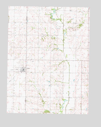
Clearfield, IA USGS Topographic Map
Click on map above to begin viewing in our Map Viewer.

This topographic map contains these locations and features:
Feature Name Type Latitude Longitude GNIS ID View Map
Area Bible Fellowship ChurchChurchN40.8008°W94.4758°1968842View Map
Cabaret CemeteryCemeteryN40.7983°W94.3861°1822910View Map
City of ClearfieldCivilN40.8025°W94.4826°2393552View Map
ClearfieldPopulated PlaceN40.8008°W94.4758°455468View Map
Clearfield (historical)LocaleN40.8022°W94.4752°1968850View Map
Clearfield CemeteryCemeteryN40.8103°W94.4633°1822909View Map
Clearfield Christian ChurchChurchN40.8008°W94.4758°1968841View Map
Clearfield City HallBuildingN40.8008°W94.4758°1968843View Map
Clearfield Elementary SchoolSchoolN40.7979°W94.4786°1968849View Map
Clearfield Fire DepartmentBuildingN40.8009°W94.4765°1968844View Map
Clearfield Post OfficePost OfficeN40.8008°W94.4758°1968847View Map
Clearfield Public LibraryBuildingN40.8008°W94.4758°1968845View Map
Clearview HomeHospitalN40.8008°W94.4758°1968846View Map
Gard BranchStreamN40.8347°W94.4147°1823129View Map
Lone Office Post Office (historical)Post OfficeN40.8528°W94.4877°1968857View Map
MarenaLocaleN40.8417°W94.3961°466354View Map
Marena Post Office (historical)Post OfficeN40.8500°W94.4088°466517View Map
Methodist ChurchChurchN40.8008°W94.4758°1968848View Map
Rising Sun CemeteryCemeteryN40.8711°W94.4066°1822911View Map
Tindle CemeteryCemeteryN40.8561°W94.3958°1822939View Map
Township of GrantCivilN40.7706°W94.4167°467953View Map
Township of LincolnCivilN40.8559°W94.4146°468267View Map

Note: Coordinates in the location and feature list above are referenced to NAD83 datum.


Copyright (C) 2008-2025 Ryan Niemi / Sunset Dynamics ... All Rights Reserved