TopoQuest Logo
Do you find TopoQuest useful?
Help keep TopoQuest running and adding new maps/features by donating!
Bitcoin:  19c7KJd3qBynnjoSw5npx9KScwjBe4ifkT
Litecoin:  LXs6TkuXGGXo1vDsWCkWVdjQX94eUKd6ui
Home View Maps Find Maps Find Places Resources & Links


Clegg NE, Texas Topographic Map

USGS Map Title: Clegg NE, TX
USGS Map MRC: 28098B3
DRG (GeoTIFF) Download: o28098b3.tif


Neighboring USGS Topographic Map Quads:


  San Caja Hill, TX  
28098C4
 

  Live Oak Hollow, TX  
28098C3
 

  Oakville SW, TX  
28098C2
 

  La Chusa Hill, TX  
28098B4
 

  Clegg NE, TX  
28098B3
 

  Elm Creek, TX  
28098B2
 

  Clegg SW, TX  
28098A4
 

  Clegg, TX  
28098A3
 

  Anna Rose, TX  
28098A2


Map MRC Location:

N29°
W99°
N29°
W98°
H8 H7 H6 H5 H4 H3 H2 H1
G8 G7 G6 G5 G4 G3 G2 G1
F8 F7 F6 F5 F4 F3 F2 F1
E8 E7 E6 E5 E4 E3 E2 E1
D8 D7 D6 D5 D4 D3 D2 D1
C8 C7 C6 C5 C4 C3 C2 C1
B8 B7 B6 B5 B4 B3 B2 B1
A8 A7 A6 A5 A4 A3 A2 A1
N28°
W99°
N28°
W98°

Clegg NE, TX USGS 1:24K Topographic Map Preview:
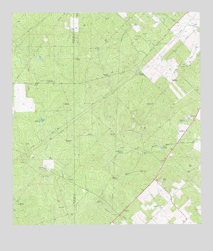
Clegg NE, TX USGS Topographic Map
Click on map above to begin viewing in our Map Viewer.

This topographic map contains these locations and features:
Feature Name Type Latitude Longitude GNIS ID View Map
Aqua Sola WindmillLocaleN28.1964°W98.2825°1329642View Map
Aqua Verde WindmillLocaleN28.1789°W98.3061°1329643View Map
Caliche TankReservoirN28.1862°W98.2614°1331884View Map
Coma WellWellN28.1681°W98.2872°1333161View Map
Crystal WindmillLocaleN28.1786°W98.3220°1333763View Map
Daugherty RanchLocaleN28.1589°W98.3522°1334061View Map
Debisadero WindmillLocaleN28.2133°W98.3103°1334169View Map
Dino TankReservoirN28.1705°W98.2753°1334376View Map
Green Pump WellWellN28.1556°W98.2997°1336939View Map
Iley RanchLocaleN28.1650°W98.2722°1338368View Map
Jaboncillo WindmillLocaleN28.2103°W98.2656°1338543View Map
Jack West WindmillLocaleN28.2144°W98.2897°1338558View Map
Jediondo WindmillLocaleN28.1375°W98.3708°1338686View Map
Lease WindmillLocaleN28.2289°W98.3161°1339760View Map
Little WellWellN28.2083°W98.3595°1340214View Map
Lyne RanchLocaleN28.2433°W98.2545°1340757View Map
Marcou TankReservoirN28.1867°W98.3562°1340936View Map
Marcou WindmillLocaleN28.1864°W98.3570°1340937View Map
Morris WindmillLocaleN28.2231°W98.3314°1341943View Map
Muerto WindmillLocaleN28.1389°W98.3164°1342228View Map
Nichols WindmillLocaleN28.1967°W98.3372°1342589View Map
Nine Hundred WindmillLocaleN28.2100°W98.3475°1342599View Map
Palo Blanco TankReservoirN28.1687°W98.3037°1343485View Map
Piggly Wiggly WindmillLocaleN28.1750°W98.3392°1343991View Map
Preza WindmillLocaleN28.1531°W98.3083°1344552View Map
Salado WindmillLocaleN28.1522°W98.3375°1346151View Map
Salt WellWellN28.1808°W98.2953°1346249View Map

Note: Coordinates in the location and feature list above are referenced to NAD83 datum.


Copyright (C) 2008-2025 Ryan Niemi / Sunset Dynamics ... All Rights Reserved