TopoQuest Logo
Do you find TopoQuest useful?
Help keep TopoQuest running and adding new maps/features by donating!
Bitcoin:  19c7KJd3qBynnjoSw5npx9KScwjBe4ifkT
Litecoin:  LXs6TkuXGGXo1vDsWCkWVdjQX94eUKd6ui
Home View Maps Find Maps Find Places Resources & Links


Clifdale, North Carolina Topographic Map

USGS Map Title: Clifdale, NC
USGS Map MRC: 35079A1
DRG (GeoTIFF) Download: o35079a1.tif


Neighboring USGS Topographic Map Quads:


  Lobelia, NC  
35079B2
 

  Overhills, NC  
35079B1
 

  Manchester, NC  
35078B8
 

  Nicholson Creek, NC  
35079A2
 

  Clifdale, NC  
35079A1
 

  Fayetteville, NC  
35078A8
 

  Raeford, NC  
34079H2
 

  Parkton, NC  
34079H1
 

  Hope Mills, NC  
34078H8


Map MRC Location:

N36°
W80°
N36°
W79°
H8 H7 H6 H5 H4 H3 H2 H1
G8 G7 G6 G5 G4 G3 G2 G1
F8 F7 F6 F5 F4 F3 F2 F1
E8 E7 E6 E5 E4 E3 E2 E1
D8 D7 D6 D5 D4 D3 D2 D1
C8 C7 C6 C5 C4 C3 C2 C1
B8 B7 B6 B5 B4 B3 B2 B1
A8 A7 A6 A5 A4 A3 A2 A1
N35°
W80°
N35°
W79°

Clifdale, NC USGS 1:24K Topographic Map Preview:
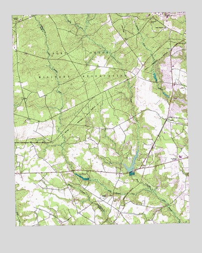
Clifdale, NC USGS Topographic Map
Click on map above to begin viewing in our Map Viewer.

This topographic map contains these locations and features:
Feature Name Type Latitude Longitude GNIS ID View Map
Atlantic Coastal PlainPlainN35.0004°W79.0000°528963View Map
Benjamin J Martin Elementary SchoolSchoolN35.0932°W79.0095°1006522View Map
Bluesprings WoodsPopulated PlaceN35.0204°W79.0073°1004873View Map
Bones CreekStreamN35.0193°W79.0273°981714View Map
Bones FordPopulated PlaceN35.1191°W79.0800°1019248View Map
Caisson HillSummitN35.1196°W79.0259°982411View Map
ClifdalePopulated PlaceN35.0616°W79.0153°1019696View Map
Emerald GardensPopulated PlaceN35.0177°W79.0023°1004872View Map
Fayetteville Fire Department Station 11BuildingN35.0310°W79.0523°2638796View Map
Fayetteville Fire Department Station 15BuildingN35.0571°W79.0561°2638989View Map
Fayetteville Fire Department Station 8BuildingN35.0528°W79.0121°2638985View Map
FenixPopulated PlaceN35.0332°W79.0348°1020231View Map
Fort Bragg Fire and Emergency Services Station 5BuildingN35.1178°W79.0137°2638716View Map
Galatia ChurchChurchN35.0166°W79.0603°985520View Map
GlenbrookPopulated PlaceN35.0513°W79.0011°1004874View Map
Hickory GrovePopulated PlaceN35.0254°W79.0095°1004871View Map
Hutaff LakeReservoirN35.0870°W79.0227°998373View Map
J C Keith DamDamN35.0222°W79.0227°998311View Map
J C Keith LakeReservoirN35.0238°W79.0213°998310View Map
Lake RimReservoirN35.0363°W79.0403°998321View Map
Lake Rim DamDamN35.0318°W79.0414°998322View Map
Lake WilliamReservoirN35.0282°W79.0759°997355View Map
Lake Williams DamDamN35.0268°W79.0714°998316View Map
Loch LommondPopulated PlaceN35.0696°W79.0075°1004875View Map
Lommond LakeLakeN35.0723°W79.0037°1004876View Map
Longstreet ChurchChurchN35.1221°W79.1203°989019View Map
Loraine LakeReservoirN35.0762°W79.0151°998361View Map
Loraine Lake DamDamN35.0752°W79.0131°998362View Map
Mac RidgeRidgeN35.1124°W79.0434°989165View Map
NC Noname Eighty-Two DamDamN35.0885°W79.0231°998374View Map
Puppy Creek Fire DepartmentBuildingN35.0260°W79.1180°2639306View Map
Saint James Inn Airport (historical)AirportN35.0752°W79.0748°997883View Map
Seventy-First Elementary SchoolSchoolN35.0382°W79.0092°1006523View Map
Seventyfirst High SchoolSchoolN35.0382°W79.0092°994517View Map
Township of McLauchlinCivilN35.0004°W79.1086°1026803View Map
Township of Seventy-FirstCivilN35.0745°W79.0229°1026604View Map
Vaughn HillSummitN35.1241°W79.0150°996602View Map
W P Sanders Pond DamReservoirN35.0579°W79.0296°998349View Map
W P Sanders Pond DamDamN35.0568°W79.0314°998350View Map
West Newton HillSummitN35.1177°W79.0131°997032View Map

Note: Coordinates in the location and feature list above are referenced to NAD83 datum.


Copyright (C) 2008-2025 Ryan Niemi / Sunset Dynamics ... All Rights Reserved