TopoQuest Logo
Do you find TopoQuest useful?
Help keep TopoQuest running and adding new maps/features by donating!
Bitcoin:  19c7KJd3qBynnjoSw5npx9KScwjBe4ifkT
Litecoin:  LXs6TkuXGGXo1vDsWCkWVdjQX94eUKd6ui
Home View Maps Find Maps Find Places Resources & Links


Clifton, Texas Topographic Map

USGS Map Title: Clifton, TX
USGS Map MRC: 31097G5
DRG (GeoTIFF) Download: o31097g5.tif


Neighboring USGS Topographic Map Quads:


  Meridian, TX  
31097H6
 

  Pilot Knob, TX  
31097H5
 

  Allen Bend, TX  
31097H4
 

  Sugarloaf Mountain, TX  
31097G6
 

  Clifton, TX  
31097G5
 

  Laguna Park, TX  
31097G4
 

  Hurst Spring, TX  
31097F6
 

  Mosheim, TX  
31097F5
 

  Valley Mills, TX  
31097F4


Map MRC Location:

N32°
W98°
N32°
W97°
H8 H7 H6 H5 H4 H3 H2 H1
G8 G7 G6 G5 G4 G3 G2 G1
F8 F7 F6 F5 F4 F3 F2 F1
E8 E7 E6 E5 E4 E3 E2 E1
D8 D7 D6 D5 D4 D3 D2 D1
C8 C7 C6 C5 C4 C3 C2 C1
B8 B7 B6 B5 B4 B3 B2 B1
A8 A7 A6 A5 A4 A3 A2 A1
N31°
W98°
N31°
W97°

Clifton, TX USGS 1:24K Topographic Map Preview:
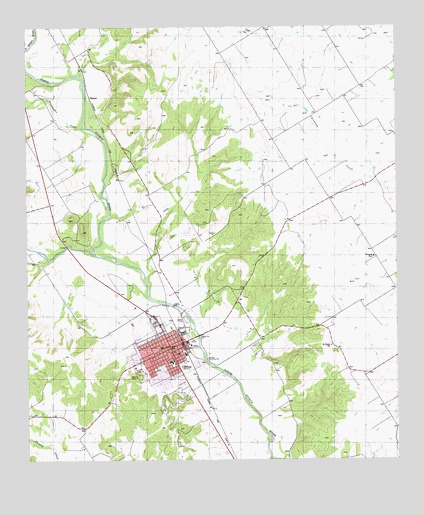
Clifton, TX USGS Topographic Map
Click on map above to begin viewing in our Map Viewer.

This topographic map contains these locations and features:
Feature Name Type Latitude Longitude GNIS ID View Map
BosquePopulated PlaceN31.8549°W97.6039°1378035View Map
Bosque Memorial MuseumBuildingN31.7763°W97.5850°2014338View Map
City of CliftonCivilN31.7823°W97.5824°2409484View Map
CliftonPopulated PlaceN31.7824°W97.5767°1332988View Map
Clifton CemeteryCemeteryN31.7721°W97.5731°1332990View Map
Clifton City HallBuildingN31.7837°W97.5757°2753501View Map
Clifton Elementary SchoolSchoolN31.7793°W97.5767°2003578View Map
Clifton Middle SchoolSchoolN31.7790°W97.5761°2003580View Map
Clifton Municipal Airport/Isenhower FieldAirportN31.8160°W97.5694°1384783View Map
Clifton Police DepartmentBuildingN31.7843°W97.5759°2739287View Map
Clifton Post OfficePost OfficeN31.7832°W97.5754°2731401View Map
Clifton Volunteer Fire DepartmentBuildingN31.7855°W97.5760°2552614View Map
Cub StadiumParkN31.7877°W97.5909°2027941View Map
First Baptist ChurchChurchN31.7815°W97.5753°2016806View Map
First Presbyterian ChurchChurchN31.7813°W97.5761°2016745View Map
Fundamental Baptist ChurchChurchN31.7863°W97.5767°2016739View Map
Goodall - Witcher Healthcare Foundation HospitalHospitalN31.7768°W97.5890°2015632View Map
Grace Memorial Baptist ChurchChurchN31.7802°W97.5825°2016740View Map
Gunarus and Ingerborg Shefstad HouseBuildingN31.7957°W97.5872°2031079View Map
Holy Angels Catholic ChurchChurchN31.7777°W97.5889°2016742View Map
J H Bekken HouseBuildingN31.7965°W97.6136°2030992View Map
KWOW-FM (Clifton)TowerN31.7774°W97.6003°1385811View Map
Meridian CreekStreamN31.8093°W97.6017°1374883View Map
Mermaid Swimming PoolLocaleN31.7793°W97.5647°1384426View Map
North Bosque Emergency Medical ServicesBuildingN31.7855°W97.5760°2655955View Map
Old Mill DamDamN31.7952°W97.5753°1861050View Map
Old Mill LakeReservoirN31.7952°W97.5753°1861051View Map
Olsen LakeReservoirN31.7785°W97.5653°1863966View Map
Olsen Lake DamDamN31.7785°W97.5653°1863965View Map
Oswald CemeteryCemeteryN31.8149°W97.5781°1343333View Map
Peder Dahl FarmLocaleN31.7535°W97.6067°2032048View Map
Pentecostal Church of GodChurchN31.7868°W97.5784°2016744View Map
Saint Pauls ChurchChurchN31.7832°W97.5231°1346090View Map
Schumacher CreekStreamN31.8460°W97.6056°1372201View Map
Shiloh Baptist ChurchChurchN31.7871°W97.5736°2016741View Map
Sunset HomeBuildingN31.7760°W97.5864°1348090View Map
Trinity Lutheran ChurchChurchN31.7829°W97.5781°2016743View Map
Womack HallLocaleN31.8085°W97.5081°1350498View Map

Note: Coordinates in the location and feature list above are referenced to NAD83 datum.


Copyright (C) 2008-2024 Ryan Niemi / Sunset Dynamics ... All Rights Reserved