TopoQuest Logo
Do you find TopoQuest useful?
Help keep TopoQuest running and adding new maps/features by donating!
Bitcoin:  19c7KJd3qBynnjoSw5npx9KScwjBe4ifkT
Litecoin:  LXs6TkuXGGXo1vDsWCkWVdjQX94eUKd6ui
Home View Maps Find Maps Find Places Resources & Links


Cline, Texas Topographic Map

USGS Map Title: Cline, TX
USGS Map MRC: 29100B1
DRG (GeoTIFF) Download: o29100b1.tif


Neighboring USGS Topographic Map Quads:


  Turkey Mountain, TX  
29100C2
 

  Mustang Waterhole, TX  
29100C1
 

  Chalk Bluff, TX  
29099C8
 

  Odlaw, TX  
29100B2
 

  Cline, TX  
29100B1
 

  Hacienda, TX  
29099B8
 

  Goofy Lake, TX  
29100A2
 

  Olmos Creek, TX  
29100A1
 

  Sand Mountain, TX  
29099A8


Map MRC Location:

N30°
W101°
N30°
W100°
H8 H7 H6 H5 H4 H3 H2 H1
G8 G7 G6 G5 G4 G3 G2 G1
F8 F7 F6 F5 F4 F3 F2 F1
E8 E7 E6 E5 E4 E3 E2 E1
D8 D7 D6 D5 D4 D3 D2 D1
C8 C7 C6 C5 C4 C3 C2 C1
B8 B7 B6 B5 B4 B3 B2 B1
A8 A7 A6 A5 A4 A3 A2 A1
N29°
W101°
N29°
W100°

Cline, TX USGS 1:24K Topographic Map Preview:
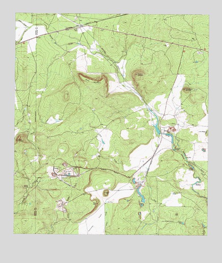
Cline, TX USGS Topographic Map
Click on map above to begin viewing in our Map Viewer.

This topographic map contains these locations and features:
Feature Name Type Latitude Longitude GNIS ID View Map
Asphalt MountainSummitN29.2161°W100.0456°1351314View Map
Big HillSummitN29.1427°W100.0723°1352076View Map
Bird HillSummitN29.1369°W100.0215°1352220View Map
BlewettPopulated PlaceN29.1850°W100.0306°1379430View Map
ClinePopulated PlaceN29.2433°W100.0828°1379561View Map
Cline MountainSummitN29.2116°W100.0706°1354673View Map
Dabney (historical)Populated PlaceN29.1625°W100.0995°1379629View Map
Dawson WaterholeLakeN29.1549°W100.0080°1355726View Map
East Fork Turkey CreekStreamN29.2422°W100.1156°1356640View Map
Frypan ValleyBasinN29.1852°W100.1242°1357794View Map
Gato QuarryMineN29.1527°W100.0459°1357927View Map
Gold HillSummitN29.1489°W100.0656°1358114View Map
Golondrina WaterholeReservoirN29.1736°W100.0222°1358138View Map
Indian SpringSpringN29.1516°W100.1165°1359982View Map
Kennedy FlatsFlatN29.1283°W100.0745°1360579View Map
Lone Mesquite HillSummitN29.1839°W100.0006°1374685View Map
Long HoleReservoirN29.1696°W100.0149°1361729View Map
Middle TankReservoirN29.1320°W100.0163°1362754View Map
Muela MountainSummitN29.1780°W100.1228°1363427View Map
Red TankReservoirN29.1437°W100.0653°1366224View Map
Saddleback MountainSummitN29.2077°W100.0151°1367106View Map
Smyth QuarryMineN29.1408°W100.0970°1368530View Map
Sparks CemeteryCemeteryN29.2408°W100.0845°1368876View Map
Uvalde QuarryMineN29.1586°W100.0942°2710179View Map
Uvalde Rock Asphalt Company DamDamN29.1772°W100.0234°1862402View Map
Uvalde Rock Asphalt Company LakeReservoirN29.1819°W100.0263°1862403View Map
West Dawson TankReservoirN29.1488°W100.0226°1371108View Map
West Fork Turkey CreekStreamN29.2422°W100.1156°1371156View Map
White Company LakeReservoirN29.1870°W100.0335°1862401View Map
White Company Lake DamDamN29.1826°W100.0315°1862400View Map
Whites East PitLakeN29.1635°W100.0100°1371456View Map
Whites MineMineN29.1602°W100.0909°1371457View Map

Note: Coordinates in the location and feature list above are referenced to NAD83 datum.


Copyright (C) 2008-2025 Ryan Niemi / Sunset Dynamics ... All Rights Reserved