TopoQuest Logo
Do you find TopoQuest useful?
Help keep TopoQuest running and adding new maps/features by donating!
Bitcoin:  19c7KJd3qBynnjoSw5npx9KScwjBe4ifkT
Litecoin:  LXs6TkuXGGXo1vDsWCkWVdjQX94eUKd6ui
Home View Maps Find Maps Find Places Resources & Links


Clinton NW, Iowa Topographic Map

USGS Map Title: Clinton NW, IA
USGS Map MRC: 41090H2
DRG (GeoTIFF) Download: o41090h2.tif


Neighboring USGS Topographic Map Quads:


  Miles, IA  
42090A3
 

  Savanna, IL  
42090A2
 

  Wacker, IL  
42090A1
 

  Andover, IA  
41090H3
 

  Clinton NW, IA  
41090H2
 

  Thomson, IL  
41090H1
 

  Camanche, IA  
41090G3
 

  Clinton, IA  
41090G2
 

  Union Grove, IL  
41090G1


Map MRC Location:

N42°
W91°
N42°
W90°
H8 H7 H6 H5 H4 H3 H2 H1
G8 G7 G6 G5 G4 G3 G2 G1
F8 F7 F6 F5 F4 F3 F2 F1
E8 E7 E6 E5 E4 E3 E2 E1
D8 D7 D6 D5 D4 D3 D2 D1
C8 C7 C6 C5 C4 C3 C2 C1
B8 B7 B6 B5 B4 B3 B2 B1
A8 A7 A6 A5 A4 A3 A2 A1
N41°
W91°
N41°
W90°

Clinton NW, IA USGS 1:24K Topographic Map Preview:
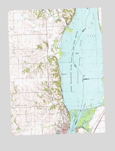
Clinton NW, IA USGS Topographic Map
Click on map above to begin viewing in our Map Viewer.

This topographic map contains these locations and features:
Feature Name Type Latitude Longitude GNIS ID View Map
AlmontPopulated PlaceN41.9753°W90.1990°464441View Map
Almont (historical)LocaleN41.9797°W90.1951°2000643View Map
Almont Post Office (historical)Post OfficeN41.9753°W90.1990°2000644View Map
Bald PointCliffN41.9856°W90.1701°454329View Map
Buell SchoolSchoolN41.8820°W90.1787°454945View Map
Bulgers HollowPopulated PlaceN41.9353°W90.1840°464480View Map
Calvary CemeteryCemeteryN41.8759°W90.1643°405404View Map
Calvary CemeteryCemeteryN41.8945°W90.1810°455072View Map
Cattail SloughStreamN41.8806°W90.1640°405711View Map
Clinton County Historical Society MuseumBuildingN41.8759°W90.1896°2000665View Map
Deer CreekStreamN41.9067°W90.1782°455849View Map
Dierks CemeteryCemeteryN41.8881°W90.2237°455918View Map
Eagle Heights Elementary SchoolSchoolN41.8778°W90.1975°2719796View Map
Eagle Point Nursing and Rehabilitation CenterHospitalN41.8778°W90.1904°2000685View Map
Eagle Point ParkParkN41.9036°W90.1793°456098View Map
Elk RiverStreamN41.9809°W90.1616°1823590View Map
Elk River JunctionPopulated PlaceN41.9797°W90.1740°464534View Map
Elk River Post Office (historical)Post OfficeN41.9986°W90.1974°2000641View Map
Elk River SloughGutN41.9767°W90.1592°2747030View Map
First Church of the NazareneChurchN41.8945°W90.2082°2000723View Map
Flannery School (historical)SchoolN41.8953°W90.1751°2000671View Map
Gomers LakeLakeN41.9672°W90.1757°2747029View Map
Hauntown CemeteryCemeteryN41.9889°W90.1974°2000867View Map
Jehovahs Witnesses North CongregationChurchN41.8881°W90.1760°2000707View Map
Johnson CreekStreamN41.8906°W90.1579°411165View Map
KCLN-FM (Clinton)TowerN41.9089°W90.2224°467308View Map
KLNT-AM (Clinton)TowerN41.9089°W90.2212°467250View Map
KNJY-FM (Clinton)TowerN41.9089°W90.2224°463718View Map
Lock and Dam 13DamN41.8985°W90.1573°463439View Map
Lock and Dam NoDamN41.8984°W90.1573°458549View Map
Lock and Dam Number 13DamN41.8981°W90.1560°425122View Map
Lyons ChuteStreamN41.8875°W90.1690°458697View Map
Lyons Middle SchoolSchoolN41.8802°W90.1859°2000732View Map
Lyons QuarryMineN41.9108°W90.1925°2571530View Map
Mead (historical)LocaleN41.9500°W90.1857°2000646View Map
Mead Post Office (historical)Post OfficeN41.9500°W90.1857°2000645View Map
Oakland CemeteryCemeteryN41.8964°W90.1801°459758View Map
Pomme de Terre PrairieFlatN41.9661°W90.1862°460355View Map
Pool 13ReservoirN41.9006°W90.1593°2746777View Map
Saint Boniface CemeteryCemeteryN41.8961°W90.1846°460951View Map
Saint Irenaeus Catholic ChurchChurchN41.8781°W90.1776°2000704View Map
Saint Irenaeus SchoolSchoolN41.8781°W90.1771°460983View Map
Sibyl (historical)Populated PlaceN41.9492°W90.1854°465527View Map
Silver CreekStreamN41.9525°W90.1765°461611View Map
Smith CemeteryCemeteryN41.9741°W90.1946°461689View Map
Soaring Eagles Nature CenterLocaleN41.8953°W90.1751°2000672View Map
Stamps IslandIslandN41.8903°W90.1648°461949View Map
Swedes LakeLakeN41.8862°W90.1538°419472View Map
Township of Elk RiverCivilN41.9899°W90.2319°467782View Map
Township of FultonCivilN41.8833°W90.1291°429033View Map
Walkyns GlenLocaleN41.9695°W90.1793°466073View Map
Wares LakeLakeN41.8916°W90.1428°420530View Map
Watkyns Glen Post Office (historical)Post OfficeN41.9834°W90.2085°2000642View Map
Willow BrookStreamN41.8750°W90.1743°463069View Map
Wilson CemeteryCemeteryN41.9642°W90.2121°463101View Map
Woodruffs IslandIslandN41.9553°W90.1612°421471View Map

Note: Coordinates in the location and feature list above are referenced to NAD83 datum.


Copyright (C) 2008-2024 Ryan Niemi / Sunset Dynamics ... All Rights Reserved