TopoQuest Logo
Do you find TopoQuest useful?
Help keep TopoQuest running and adding new maps/features by donating!
Bitcoin:  19c7KJd3qBynnjoSw5npx9KScwjBe4ifkT
Litecoin:  LXs6TkuXGGXo1vDsWCkWVdjQX94eUKd6ui
Home View Maps Find Maps Find Places Resources & Links


Clyattville, Georgia Topographic Map

USGS Map Title: Clyattville, GA
USGS Map MRC: 30083F3
DRG (GeoTIFF) Download: o30083f3.tif


Neighboring USGS Topographic Map Quads:


  Ousley, GA  
30083G4
 

  Valdosta, GA  
30083G3


  Nankin, GA  
30083F4
 

  Clyattville, GA  
30083F3
 

  Lake Park, GA  
30083F2
 

  Cherry Lake, FL  
30083E4
 

  Pinetta, FL  
30083E3
 

  Octahatchee, FL  
30083E2


Map MRC Location:

N31°
W84°
N31°
W83°
H8 H7 H6 H5 H4 H3 H2 H1
G8 G7 G6 G5 G4 G3 G2 G1
F8 F7 F6 F5 F4 F3 F2 F1
E8 E7 E6 E5 E4 E3 E2 E1
D8 D7 D6 D5 D4 D3 D2 D1
C8 C7 C6 C5 C4 C3 C2 C1
B8 B7 B6 B5 B4 B3 B2 B1
A8 A7 A6 A5 A4 A3 A2 A1
N30°
W84°
N30°
W83°

Clyattville, GA USGS 1:24K Topographic Map Preview:
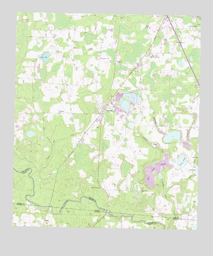
Clyattville, GA USGS Topographic Map
Click on map above to begin viewing in our Map Viewer.

This topographic map contains these locations and features:
Feature Name Type Latitude Longitude GNIS ID View Map
Alpha and Omega ChurchChurchN30.7294°W83.2835°346196View Map
Bear Garden SwampLakeN30.6594°W83.2784°354502View Map
Bear Garden Swamp DamDamN30.6585°W83.2765°342188View Map
Benevolence ChurchChurchN30.7238°W83.3168°354547View Map
Bevel CreekStreamN30.6469°W83.2721°311279View Map
BriggstonPopulated PlaceN30.7216°W83.3057°326194View Map
Brown PondLakeN30.6650°W83.2607°311875View Map
Carrolls PondReservoirN30.6562°W83.2753°342191View Map
Carrolls Pond DamDamN30.6552°W83.2749°342190View Map
Clyatt Mill CreekStreamN30.6541°W83.3629°355200View Map
ClyattvillePopulated PlaceN30.6916°W83.3152°312772View Map
Clyattville Elementary SchoolSchoolN30.6877°W83.3168°346225View Map
Clyattville Lake Park SchoolSchoolN30.7258°W83.2827°312773View Map
Clyattville Post OfficePost OfficeN30.6891°W83.3160°346226View Map
Clyattville Volunteer Fire Department Station 2BuildingN30.6991°W83.3116°2604865View Map
Copeland CemeteryCemeteryN30.7433°W83.2585°346228View Map
Forest Grove CemeteryCemeteryN30.7035°W83.3438°314266View Map
Greenwater BranchStreamN30.6755°W83.2521°356106View Map
Horn BridgeBridgeN30.6355°W83.3113°346267View Map
Hunter CemeteryCemeteryN30.7085°W83.3354°352297View Map
Jackson School (historical)SchoolN30.7410°W83.3129°346274View Map
Lane CemeteryCemeteryN30.6835°W83.3076°346282View Map
Lanes Mill CreekStreamN30.6727°W83.3485°316624View Map
Lanes PondSwampN30.7240°W83.3549°316625View Map
Little Bethel ChurchChurchN30.7191°W83.3621°346287View Map
Loch Laurel ChurchChurchN30.7441°W83.2521°346288View Map
McIntyre Spring (historical)Populated PlaceN30.6410°W83.3665°347452View Map
Mount Calvary ChurchChurchN30.7344°W83.2660°318569View Map
Mount Zion ChurchChurchN30.7458°W83.3713°318929View Map
New Mount Zion ChurchChurchN30.6483°W83.3151°319485View Map
Ochlawilla ChurchChurchN30.6919°W83.3446°319887View Map
Old ClyattvillePopulated PlaceN30.7105°W83.3202°346315View Map
Olympia (historical)Populated PlaceN30.6547°W83.3457°346316View Map
Owens Illinois LakeReservoirN30.7021°W83.3047°342193View Map
Owens Illinois Lake DamDamN30.7035°W83.3065°342192View Map
Owens-Illinois Corporation LakeReservoirN30.6971°W83.2997°342195View Map
Owens-Illinois Corporation Lake DamDamN30.6952°W83.2999°342194View Map
Payton ChurchChurchN30.6472°W83.2882°320302View Map
SmithLocaleN30.6283°W83.3535°295635View Map
Sunset LakeReservoirN30.6598°W83.2509°323773View Map
Union ChurchChurchN30.7371°W83.2651°324502View Map
Whitewater Club LakeReservoirN30.6794°W83.2676°338354View Map
Whitewater Club Lake DamDamN30.6769°W83.2615°338353View Map
Whitewater CreekStreamN30.6805°W83.2715°325225View Map
Woods Chapel ChurchChurchN30.7271°W83.3457°346384View Map
Zeigler LakeSwampN30.6416°W83.2560°346385View Map

Note: Coordinates in the location and feature list above are referenced to NAD83 datum.


Copyright (C) 2008-2025 Ryan Niemi / Sunset Dynamics ... All Rights Reserved