TopoQuest Logo
Do you find TopoQuest useful?
Help keep TopoQuest running and adding new maps/features by donating!
Bitcoin:  19c7KJd3qBynnjoSw5npx9KScwjBe4ifkT
Litecoin:  LXs6TkuXGGXo1vDsWCkWVdjQX94eUKd6ui
Home View Maps Find Maps Find Places Resources & Links


Collbran, Colorado Topographic Map

USGS Map Title: Collbran, CO
USGS Map MRC: 39107B8
DRG (GeoTIFF) Download: o39107b8.tif


Neighboring USGS Topographic Map Quads:


  Housetop Mountain, CO  
39108C1
 

  Hawxhurst Creek, CO  
39107C8
 

  South Mamm Peak, CO  
39107C7
 

  Molina, CO  
39108B1
 

  Collbran, CO  
39107B8
 

  Vega Reservoir, CO  
39107B7
 

  Mesa Lakes, CO  
39108A1
 

  Grand Mesa, CO  
39107A8
 

  Leon Peak, CO  
39107A7


Map MRC Location:

N40°
W108°
N40°
W107°
H8 H7 H6 H5 H4 H3 H2 H1
G8 G7 G6 G5 G4 G3 G2 G1
F8 F7 F6 F5 F4 F3 F2 F1
E8 E7 E6 E5 E4 E3 E2 E1
D8 D7 D6 D5 D4 D3 D2 D1
C8 C7 C6 C5 C4 C3 C2 C1
B8 B7 B6 B5 B4 B3 B2 B1
A8 A7 A6 A5 A4 A3 A2 A1
N39°
W108°
N39°
W107°

Collbran, CO USGS 1:24K Topographic Map Preview:
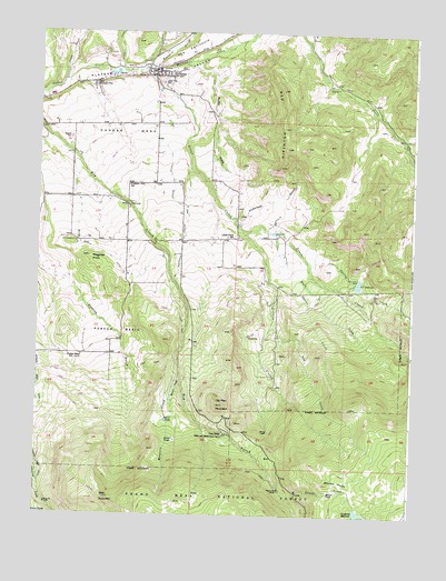
Collbran, CO USGS Topographic Map
Click on map above to begin viewing in our Map Viewer.

This topographic map contains these locations and features:
Feature Name Type Latitude Longitude GNIS ID View Map
Anderson GulchValleyN39.2008°W107.9335°175062View Map
Bald MountainSummitN39.1294°W107.9767°175039View Map
Baxter CreekStreamN39.1294°W107.9159°175044View Map
Baxter PointCliffN39.1333°W107.9026°175043View Map
Berthold Updyke and Landon DitchCanalN39.2094°W107.9556°175059View Map
Buzzard CreekStreamN39.2414°W107.9642°175049View Map
Carpenter DamDamN39.1269°W107.8928°201276View Map
Carpenter ReservoirReservoirN39.1259°W107.8923°202288View Map
Cedar Crest CemeteryCemeteryN39.2369°W107.9593°175068View Map
Clover GulchValleyN39.2380°W107.9903°174881View Map
CollbranPopulated PlaceN39.2405°W107.9612°204663View Map
Collbran DivisionCivilN39.1896°W107.8943°1935428View Map
Collbran Job CorpsLocaleN39.2380°W107.9778°196643View Map
Collbran Post OfficePost OfficeN39.2394°W107.9607°2750972View Map
Death ValleyValleyN39.1292°W107.9154°175305View Map
Eagalite CemeteryCemeteryN39.2225°W107.9898°175064View Map
Grove CreekStreamN39.2403°W107.9665°175050View Map
Kansas MesaSummitN39.2225°W107.9615°175065View Map
Kimball CreekStreamN39.2405°W107.9734°174869View Map
Knob HillSlopeN39.1711°W107.9298°175054View Map
Little CreekStreamN39.1989°W107.9323°175045View Map
Little Creek SchoolSchoolN39.1972°W107.9373°175057View Map
Maigatter KnobSummitN39.1919°W107.9834°175053View Map
Mosquito CreekStreamN39.1619°W107.9523°175040View Map
Muddy GulchValleyN39.2408°W107.9500°175067View Map
Negro CreekStreamN39.1980°W107.9212°175048View Map
Oak CreekStreamN39.1736°W107.9217°175046View Map
Old Man MountainSummitN39.1536°W107.9395°175041View Map
Parker BasinBasinN39.1725°W107.9723°175052View Map
Parker Basin SchoolLocaleN39.1661°W107.9853°175051View Map
Plateau CityPopulated PlaceN39.2372°W107.9817°175066View Map
Plateau Valley Fire Protection DistrictBuildingN39.2400°W107.9618°2667137View Map
Pleasant View SchoolSchoolN39.2105°W107.9701°175061View Map
Pretty CreekStreamN39.1269°W107.9128°196450View Map
Red MountainSummitN39.2203°W107.9103°175063View Map
Silver Gage DitchCanalN39.1928°W107.9781°175058View Map
Spring CreekStreamN39.1914°W107.9112°175055View Map
Sugarloaf PeakSummitN39.2016°W107.9037°175060View Map
Swanee CreekStreamN39.1903°W107.9170°175047View Map
Town of CollbranCivilN39.2400°W107.9640°2413226View Map
Twin Peaks Bible and Missionary CampLocaleN39.1458°W107.9367°175042View Map
Y T DamDamN39.1866°W107.8940°200072View Map
YT ReservoirReservoirN39.1852°W107.8933°175056View Map

Note: Coordinates in the location and feature list above are referenced to NAD83 datum.


Copyright (C) 2008-2025 Ryan Niemi / Sunset Dynamics ... All Rights Reserved