TopoQuest Logo
Do you find TopoQuest useful?
Help keep TopoQuest running and adding new maps/features by donating!
Bitcoin:  19c7KJd3qBynnjoSw5npx9KScwjBe4ifkT
Litecoin:  LXs6TkuXGGXo1vDsWCkWVdjQX94eUKd6ui
Home View Maps Find Maps Find Places Resources & Links


Columbia, Florida Topographic Map

USGS Map Title: Columbia, FL
USGS Map MRC: 30082A6
DRG (GeoTIFF) Download: o30082a6.tif


Neighboring USGS Topographic Map Quads:


  Wellborn, FL  
30082B7
 

  Lake City West, FL  
30082B6
 

  Lake City East, FL  
30082B5
 

  O'Brien SE, FL  
30082A7
 

  Columbia, FL  
30082A6
 

  Ellisville, FL  
30082A5
 

  Hildreth, FL  
29082H7
 

  Fort White, FL  
29082H6
 

  Mikesville, FL  
29082H5


Map MRC Location:

N31°
W83°
N31°
W82°
H8 H7 H6 H5 H4 H3 H2 H1
G8 G7 G6 G5 G4 G3 G2 G1
F8 F7 F6 F5 F4 F3 F2 F1
E8 E7 E6 E5 E4 E3 E2 E1
D8 D7 D6 D5 D4 D3 D2 D1
C8 C7 C6 C5 C4 C3 C2 C1
B8 B7 B6 B5 B4 B3 B2 B1
A8 A7 A6 A5 A4 A3 A2 A1
N30°
W83°
N30°
W82°

Columbia, FL USGS 1:24K Topographic Map Preview:
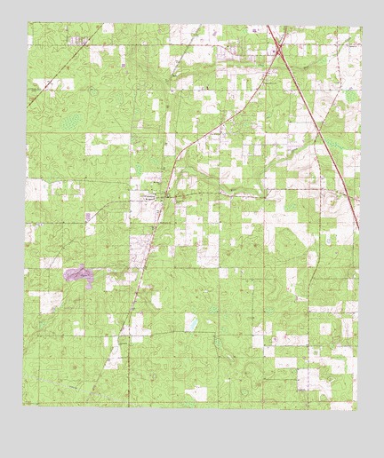
Columbia, FL USGS Topographic Map
Click on map above to begin viewing in our Map Viewer.

This topographic map contains these locations and features:
Feature Name Type Latitude Longitude GNIS ID View Map
Athens Baptist ChurchChurchN30.0594°W82.7436°2547844View Map
Athens CemeteryCemeteryN30.0592°W82.7436°2547845View Map
Athens ChurchChurchN30.0594°W82.7437°277980View Map
BassPopulated PlaceN30.1086°W82.6960°295111View Map
Berea Baptist ChurchChurchN30.1100°W82.6608°2547768View Map
Bethel African Methodist Episcopal ChurchChurchN30.1186°W82.6298°278541View Map
Cannon CreekStreamN30.1116°W82.6593°279986View Map
Clay Hole CreekStreamN30.1125°W82.6715°305482View Map
ColumbiaPopulated PlaceN30.0738°W82.6957°280670View Map
Columbia Baptist ChurchChurchN30.0781°W82.6956°2547773View Map
Columbia City Church of ChristChurchN30.0697°W82.6986°2547774View Map
Columbia City Elementary SchoolSchoolN30.0797°W82.6959°2547772View Map
Columbia City MineMineN30.0419°W82.7272°2674843View Map
Columbia City Volunteer Fire Department Station 44BuildingN30.0699°W82.6991°2547775View Map
Columbia Community CemeteryCemeteryN30.0680°W82.6944°2547843View Map
Crowncastle Radio TowerTowerN30.1075°W82.6628°2547769View Map
Delta AirportAirportN30.1206°W82.6622°309584View Map
Galilee ChurchChurchN30.0063°W82.6473°282879View Map
Jerusalem Baptist ChurchChurchN30.0208°W82.7143°284772View Map
KA2XXZ-FM (Columbia)TowerN30.1066°W82.6640°308966View Map
Mount Salem Baptist ChurchChurchN30.0675°W82.7007°287311View Map
Our Redeemer Lutheran ChurchChurchN30.1019°W82.6661°2547771View Map
Pine Rose ChurchChurchN30.0897°W82.6771°288917View Map
Pleasant Grove CemeteryCemeteryN30.1058°W82.6614°2547770View Map
Pleasant Grove United Methodist ChurchChurchN30.1058°W82.6615°289052View Map
Rose CreekStreamN30.0694°W82.6962°289959View Map
Seventh-Day Adventist ChurchChurchN30.0733°W82.6993°287314View Map
Washington ChurchChurchN30.0605°W82.6996°292909View Map

Note: Coordinates in the location and feature list above are referenced to NAD83 datum.


Copyright (C) 2008-2025 Ryan Niemi / Sunset Dynamics ... All Rights Reserved