TopoQuest Logo
Do you find TopoQuest useful?
Help keep TopoQuest running and adding new maps/features by donating!
Bitcoin:  19c7KJd3qBynnjoSw5npx9KScwjBe4ifkT
Litecoin:  LXs6TkuXGGXo1vDsWCkWVdjQX94eUKd6ui
Home View Maps Find Maps Find Places Resources & Links


Columbia East, North Carolina Topographic Map

USGS Map Title: Columbia East, NC
USGS Map MRC: 35076H2
DRG (GeoTIFF) Download: o35076h2.tif


Neighboring USGS Topographic Map Quads:


  Harvey Neck, NC  
36076A3
 

  Stevenson Point, NC  
36076A2


  Columbia West, NC  
35076H3
 

  Columbia East, NC  
35076H2
 

  Fort Landing, NC  
35076H1
 

  Creswell SE, NC  
35076G3
 

  Scotia, NC  
35076G2
 

  Frying Pan, NC  
35076G1


Map MRC Location:

N36°
W77°
N36°
W76°
H8 H7 H6 H5 H4 H3 H2 H1
G8 G7 G6 G5 G4 G3 G2 G1
F8 F7 F6 F5 F4 F3 F2 F1
E8 E7 E6 E5 E4 E3 E2 E1
D8 D7 D6 D5 D4 D3 D2 D1
C8 C7 C6 C5 C4 C3 C2 C1
B8 B7 B6 B5 B4 B3 B2 B1
A8 A7 A6 A5 A4 A3 A2 A1
N35°
W77°
N35°
W76°

Columbia East, NC USGS 1:24K Topographic Map Preview:
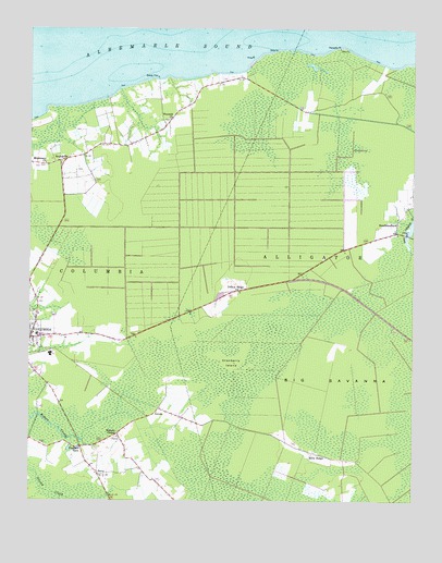
Columbia East, NC USGS Topographic Map
Click on map above to begin viewing in our Map Viewer.

This topographic map contains these locations and features:
Feature Name Type Latitude Longitude GNIS ID View Map
Alligator Fire Department Station 6BuildingN35.9826°W76.1958°2639363View Map
Big SavannaPlainN35.9074°W76.1549°981451View Map
Columbia High SchoolSchoolN35.9139°W76.2422°1003091View Map
Cranberry IslandIslandN35.9116°W76.1846°983711View Map
Dewey PierLocaleN35.9868°W76.2085°984159View Map
Dillion RidgePopulated PlaceN35.9310°W76.1816°1006176View Map
Faith Baptist ChurchChurchN35.9208°W76.2476°2505810View Map
Freewill ChurchChurchN35.9763°W76.2044°985402View Map
JerryPopulated PlaceN35.8821°W76.2269°1006256View Map
LevelsLocaleN35.8996°W76.2077°988370View Map
Malachi ChapelChurchN35.8921°W76.2210°989252View Map
Manteo Wastewater Treatment PlantLocaleN35.8866°W76.2246°2506011View Map
Mills RidgePopulated PlaceN35.8879°W76.1577°1021474View Map
Missionary ChurchChurchN35.9641°W76.2447°990085View Map
NewfoundlandPopulated PlaceN35.9485°W76.1296°1021644View Map
Palmetto PointCapeN35.9952°W76.1494°991805View Map
Pleasant ViewPopulated PlaceN35.8893°W76.2327°1022012View Map
Sandy Acres Free Baptist ChurchChurchN35.8849°W76.2317°2506263View Map
Ship PointCapeN35.9943°W76.1694°994738View Map
SoundsidePopulated PlaceN35.9652°W76.2399°1022706View Map
Town of ColumbiaCivilN35.9200°W76.2422°2406300View Map
Township of ColumbiaCivilN35.9424°W76.2463°1027237View Map
Tyrell County Water Treatment PlantLocaleN35.8910°W76.2220°2506343View Map
Tyrell Prison Work FarmBuildingN35.9573°W76.2279°2505318View Map
Tyrell Volunteer Fire DepartmentBuildingN35.9271°W76.2464°2638054View Map
Tyrrell County Emergency Medical ServicesBuildingN35.9270°W76.2464°2720480View Map
Tyrrell County Schools Administration OfficeBuildingN35.9196°W76.2491°1003093View Map
Tyrrell Elementary SchoolSchoolN35.9191°W76.2458°1003092View Map
Zion Grove Disciples ChurchChurchN35.9208°W76.2476°2506323View Map

Note: Coordinates in the location and feature list above are referenced to NAD83 datum.


Copyright (C) 2008-2025 Ryan Niemi / Sunset Dynamics ... All Rights Reserved