TopoQuest Logo
Do you find TopoQuest useful?
Help keep TopoQuest running and adding new maps/features by donating!
Bitcoin:  19c7KJd3qBynnjoSw5npx9KScwjBe4ifkT
Litecoin:  LXs6TkuXGGXo1vDsWCkWVdjQX94eUKd6ui
Home View Maps Find Maps Find Places Resources & Links


Columbia NE, Georgia Topographic Map

USGS Map Title: Columbia NE, GA
USGS Map MRC: 31085D1
DRG (GeoTIFF) Download: o31085d1.tif


Neighboring USGS Topographic Map Quads:


  Abbeville East, AL  
31085E2
 

  Fort Gaines, GA  
31085E1
 

  Zetto, GA  
31084E8
 

  Haleburg, AL  
31085D2
 

  Columbia NE, GA  
31085D1
 

  Blakely North, GA  
31084D8
 

  Sigma, AL  
31085C2
 

  Columbia, AL  
31085C1
 

  Blakely South, GA  
31084C8


Map MRC Location:

N32°
W86°
N32°
W85°
H8 H7 H6 H5 H4 H3 H2 H1
G8 G7 G6 G5 G4 G3 G2 G1
F8 F7 F6 F5 F4 F3 F2 F1
E8 E7 E6 E5 E4 E3 E2 E1
D8 D7 D6 D5 D4 D3 D2 D1
C8 C7 C6 C5 C4 C3 C2 C1
B8 B7 B6 B5 B4 B3 B2 B1
A8 A7 A6 A5 A4 A3 A2 A1
N31°
W86°
N31°
W85°

Columbia NE, GA USGS 1:24K Topographic Map Preview:
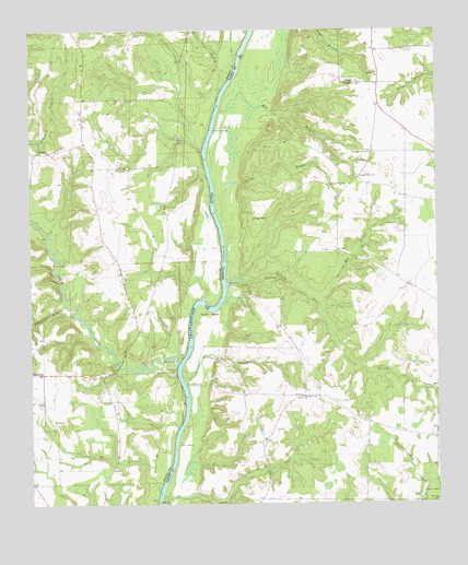
Columbia NE, GA USGS Topographic Map
Click on map above to begin viewing in our Map Viewer.

This topographic map contains these locations and features:
Feature Name Type Latitude Longitude GNIS ID View Map
Abbie CreekStreamN31.4118°W85.0799°112882View Map
Abbie Creek Public Use AreaParkN31.4127°W85.0799°132075View Map
Adams BranchStreamN31.4491°W85.0658°310391View Map
BarnesPopulated PlaceN31.4679°W85.1188°113489View Map
Barnett BranchStreamN31.4857°W85.0647°113501View Map
Bellevue ChurchChurchN31.4638°W85.0947°113887View Map
Bethel CemeteryCemeteryN31.4877°W85.0185°344798View Map
Bethel ChurchChurchN31.4879°W85.0177°354591View Map
Brickyard CreekStreamN31.4080°W85.0783°354852View Map
Bright SpringSpringN31.4599°W85.0318°311797View Map
Coates AirportAirportN31.4945°W85.0178°351773View Map
Factory CreekStreamN31.4332°W85.0641°314024View Map
Felder LakeReservoirN31.3935°W85.0599°342012View Map
Felder Lake DamDamN31.3935°W85.0599°342011View Map
Gilbert LandingLocaleN31.4743°W85.0669°331808View Map
Grimsley Mill (historical)LocaleN31.4405°W85.0255°344899View Map
Grimsley Mill BranchStreamN31.4288°W85.0360°314923View Map
Harp BranchStreamN31.4243°W85.1235°119766View Map
Hollimans and O'Neals Mill (historical)LocaleN31.4355°W85.0852°147406View Map
Hutchins LandingLocaleN31.4324°W85.0633°332049View Map
Jones LakeReservoirN31.3776°W85.0048°316243View Map
Judy BranchStreamN31.4116°W85.0419°344910View Map
McKissacks Ferry (historical)CrossingN31.4124°W85.0749°147410View Map
Mount Ararat ChurchChurchN31.3755°W85.0008°318555View Map
Mount Zion ChurchChurchN31.3968°W85.1180°123443View Map
Oak Grove ChurchChurchN31.4032°W85.0419°319771View Map
Paulk LandingLocaleN31.3918°W85.0794°332622View Map
Pleasant Grove CemeteryCemeteryN31.4674°W85.0194°344932View Map
Pleasant Grove ChurchChurchN31.4610°W85.0238°320801View Map
Pleasant Grove ChurchChurchN31.4679°W85.0199°320802View Map
Powell LandingLocaleN31.4066°W85.0763°332750View Map
Red BranchStreamN31.4788°W85.0660°321370View Map
River HillSummitN31.4502°W85.0560°332864View Map
Sardis CemeteryCemeteryN31.4020°W85.0320°322528View Map
Sardis Church (historical)ChurchN31.4021°W85.0319°344935View Map
Sardis School (historical)SchoolN31.3966°W85.0216°344936View Map
Sawyer Farm AirportAirportN31.4757°W85.0037°2717129View Map
Smith BendBendN31.4263°W85.0685°323092View Map
UrquhartPopulated PlaceN31.4738°W85.0094°344943View Map
Whetstone BranchStreamN31.4277°W85.1141°128844View Map

Note: Coordinates in the location and feature list above are referenced to NAD83 datum.


Copyright (C) 2008-2025 Ryan Niemi / Sunset Dynamics ... All Rights Reserved