TopoQuest Logo
Do you find TopoQuest useful?
Help keep TopoQuest running and adding new maps/features by donating!
Bitcoin:  19c7KJd3qBynnjoSw5npx9KScwjBe4ifkT
Litecoin:  LXs6TkuXGGXo1vDsWCkWVdjQX94eUKd6ui
Home View Maps Find Maps Find Places Resources & Links


Comanche Peak, New Mexico Topographic Map

USGS Map Title: Comanche Peak, NM
USGS Map MRC: 36105A3
DRG (GeoTIFF) Download: o36105a3.tif


Neighboring USGS Topographic Map Quads:


  Cerro Vista, NM  
36105B4
 

  Chacon, NM  
36105B3
 

  Guadalupita, NM  
36105B2
 

  Holman, NM  
36105A4
 

  Comanche Peak, NM  
36105A3
 

  Lucero, NM  
36105A2
 

  Gascon, NM  
35105H4
 

  Mora, NM  
35105H3
 

  Rainsville, NM  
35105H2


Map MRC Location:

N37°
W106°
N37°
W105°
H8 H7 H6 H5 H4 H3 H2 H1
G8 G7 G6 G5 G4 G3 G2 G1
F8 F7 F6 F5 F4 F3 F2 F1
E8 E7 E6 E5 E4 E3 E2 E1
D8 D7 D6 D5 D4 D3 D2 D1
C8 C7 C6 C5 C4 C3 C2 C1
B8 B7 B6 B5 B4 B3 B2 B1
A8 A7 A6 A5 A4 A3 A2 A1
N36°
W106°
N36°
W105°

Comanche Peak, NM USGS 1:24K Topographic Map Preview:
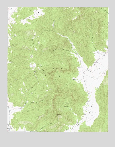
Comanche Peak, NM USGS Topographic Map
Click on map above to begin viewing in our Map Viewer.

This topographic map contains these locations and features:
Feature Name Type Latitude Longitude GNIS ID View Map
A and M MiningMineN36.0806°W105.3206°917246View Map
Caņada de la CuevaStreamN36.0278°W105.3517°897694View Map
Caņada de los LovatosStreamN36.0784°W105.2886°897705View Map
Comanche PeakSummitN36.0173°W105.3150°898748View Map
El PosoAreaN36.0667°W105.3428°888819View Map
El TurquilloPopulated PlaceN36.0798°W105.2511°915822View Map
El Turquillo Post Office (historical)Post OfficeN36.0798°W105.2511°937312View Map
El Valle de los BoregosAreaN36.1167°W105.3439°898305View Map
Encinal CreekStreamN36.0023°W105.3736°906165View Map
La Tierra AmarillaAreaN36.0273°W105.3008°890840View Map
Los ChupaderosLocaleN36.0211°W105.2725°915048View Map
Los ChupaderosAreaN36.0211°W105.2725°891353View Map
Los HornosSummitN36.0609°W105.3411°898814View Map
LucerosLocaleN36.0078°W105.3283°927338View Map
Mora DivisionCivilN36.0209°W105.3734°1937559View Map
Saint Teresa ChurchChurchN36.0698°W105.2653°894293View Map
Solis CanyonValleyN36.0775°W105.2581°894995View Map
Trumbell CanyonValleyN36.0509°W105.2822°895856View Map

Note: Coordinates in the location and feature list above are referenced to NAD83 datum.


Copyright (C) 2008-2025 Ryan Niemi / Sunset Dynamics ... All Rights Reserved