TopoQuest Logo
Do you find TopoQuest useful?
Help keep TopoQuest running and adding new maps/features by donating!
Bitcoin:  19c7KJd3qBynnjoSw5npx9KScwjBe4ifkT
Litecoin:  LXs6TkuXGGXo1vDsWCkWVdjQX94eUKd6ui
Home View Maps Find Maps Find Places Resources & Links


Condor Peak, California Topographic Map

USGS Map Title: Condor Peak, CA
USGS Map MRC: 34118C2
DRG (GeoTIFF) Download: o34118c2.tif


Neighboring USGS Topographic Map Quads:


  Agua Dulce, CA  
34118D3
 

  Acton, CA  
34118D2
 

  Pacifico Mountain, CA  
34118D1
 

  Sunland, CA  
34118C3
 

  Condor Peak, CA  
34118C2
 

  Chilao Flat, CA  
34118C1
 

  Burbank, CA  
34118B3
 

  Pasadena, CA  
34118B2
 

  Mount Wilson, CA  
34118B1


Map MRC Location:

N35°
W119°
N35°
W118°
H8 H7 H6 H5 H4 H3 H2 H1
G8 G7 G6 G5 G4 G3 G2 G1
F8 F7 F6 F5 F4 F3 F2 F1
E8 E7 E6 E5 E4 E3 E2 E1
D8 D7 D6 D5 D4 D3 D2 D1
C8 C7 C6 C5 C4 C3 C2 C1
B8 B7 B6 B5 B4 B3 B2 B1
A8 A7 A6 A5 A4 A3 A2 A1
N34°
W119°
N34°
W118°

Condor Peak, CA USGS 1:24K Topographic Map Preview:
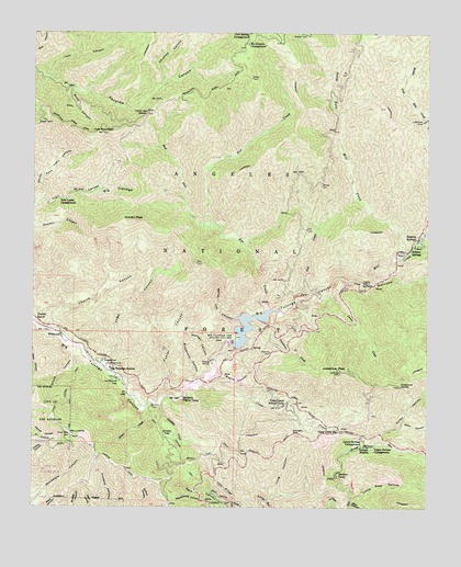
Condor Peak, CA USGS Topographic Map
Click on map above to begin viewing in our Map Viewer.

This topographic map contains these locations and features:
Feature Name Type Latitude Longitude GNIS ID View Map
Alder Glen Picnic AreaLocaleN34.2867°W118.2276°277003View Map
Bear CanyonValleyN34.2511°W118.1498°269722View Map
Big CienegaValleyN34.3333°W118.2312°269816View Map
Big Cienega Trail CampLocaleN34.3344°W118.2287°275430View Map
Big Tujunga DamDamN34.2933°W118.1884°269855View Map
Big Tujunga Number 1 32-006 DamDamN34.2933°W118.1876°1663422View Map
Big Tujunga ReservoirReservoirN34.2975°W118.1828°255960View Map
Big Tujunga StationLocaleN34.2867°W118.2267°269856View Map
Breakneck CanyonValleyN34.2839°W118.1970°270010View Map
Buck CanyonValleyN34.3606°W118.2384°270046View Map
Burbank YMCA CampLocaleN34.2789°W118.2040°270083View Map
CCC RidgeRidgeN34.2550°W118.1906°270117View Map
Chimney CanyonValleyN34.3614°W118.2115°270424View Map
Clear CreekStreamN34.2825°W118.1979°270492View Map
Clear Creek School CampLocaleN34.2769°W118.1720°270495View Map
Clear Creek StationLocaleN34.2706°W118.1542°270496View Map
Colby CanyonValleyN34.2661°W118.1437°270530View Map
Condor PeakSummitN34.3256°W118.2192°1656465View Map
Condor Peak Ridign and hiking TrailTrailN34.3069°W118.1984°275434View Map
Daisy CanyonValleyN34.2708°W118.1362°270743View Map
Dark Canyon TrailTrailN34.2653°W118.2042°270757View Map
Deer Spring CampgroundLocaleN34.3750°W118.1840°270815View Map
Fall CreekStreamN34.3061°W118.1637°271095View Map
Fall Creek CampLocaleN34.3056°W118.1590°277006View Map
Fox CreekStreamN34.3025°W118.1770°271191View Map
Fusier CanyonValleyN34.2789°W118.2095°271256View Map
Georges GapGapN34.2694°W118.1684°271290View Map
Grizzly FlatFlatN34.2697°W118.2081°271445View Map
Hansen CanyonValleyN34.2883°W118.1954°271487View Map
Hidden SpringsPopulated PlaceN34.3183°W118.1312°1656539View Map
Hidden Springs CampLocaleN34.3169°W118.1373°277005View Map
Hidden Springs Picnic AreaLocaleN34.3131°W118.1353°1655303View Map
Hoyt MountainSummitN34.2694°W118.1773°277068View Map
Indian Ben SaddleGapN34.3539°W118.2156°271706View Map
Iron CanyonValleyN34.3628°W118.2462°271727View Map
Iron MountainSummitN34.3486°W118.2295°271731View Map
Iron Target Shooting AreaLocaleN34.3528°W118.2190°1655250View Map
Josephine CreekStreamN34.3011°W118.1737°271824View Map
Josephine PeakSummitN34.2856°W118.1540°271825View Map
Josephine SaddleGapN34.2819°W118.1342°271826View Map
La Paloma FlatFlatN34.2828°W118.2237°271933View Map
Lightning Point CampgroundLocaleN34.3683°W118.1867°275437View Map
Little Bear CanyonValleyN34.2522°W118.1495°272066View Map
Lodestone MineMineN34.3517°W118.1278°272154View Map
Long CanyonValleyN34.2517°W118.1767°272176View Map
Lower Switzer CampgroundLocaleN34.2667°W118.1467°272264View Map
Lucas CreekStreamN34.3061°W118.1576°272269View Map
Maple CanyonValleyN34.2856°W118.1937°272337View Map
Middle Target Shooting AreaLocaleN34.3272°W118.1273°1655302View Map
Mill CreekStreamN34.3092°W118.1431°272466View Map
Mount Gleason CampgroundLocaleN34.3719°W118.1845°272574View Map
Mount LukensSummitN34.2689°W118.2390°272279View Map
North Fork Mill CreekStreamN34.3172°W118.1345°272694View Map
North Fork Trail CanyonValleyN34.3306°W118.2487°272704View Map
Roads End Picnic AreaLocaleN34.2822°W118.2209°277070View Map
Shoening Springs Picnic AreaLocaleN34.3075°W118.1440°1655304View Map
Silver CreekStreamN34.2758°W118.2154°273705View Map
Singing SpringsPopulated PlaceN34.3211°W118.1287°1656630View Map
Stone CanyonValleyN34.2925°W118.2379°273912View Map
Stone Canyon TrailTrailN34.2817°W118.2398°273913View Map
Stoneyvale CampgroundLocaleN34.2853°W118.2231°1802844View Map
Switzer CampLocaleN34.2589°W118.1545°273988View Map
Switzer StationLocaleN34.2661°W118.1445°273989View Map
Switzer Visitor Information StationLocaleN34.2689°W118.1456°277069View Map
The NarrowsValleyN34.3058°W118.1576°274092View Map
The Pines Picnic AreaLocaleN34.2739°W118.1606°1655307View Map
Tom Lucas CampgroundLocaleN34.3311°W118.2429°274154View Map
Upper Switzer CampgroundLocaleN34.2661°W118.1423°274298View Map
Vasquez CreekStreamN34.2767°W118.2112°274320View Map
Vogel CanyonValleyN34.2872°W118.2298°274352View Map
Vogel FlatFlatN34.2886°W118.2267°274353View Map
Vogel Flats CampgroundLocaleN34.2878°W118.2276°1655308View Map
West Fork Fox CreekStreamN34.3236°W118.1959°274431View Map
White Oak CanyonValleyN34.3000°W118.1856°274474View Map
WildwoodPopulated PlaceN34.2956°W118.2420°1656659View Map
Wildwood Picnic AreaLocaleN34.2961°W118.2426°1655301View Map
Woodwardia CanyonValleyN34.2525°W118.1926°274573View Map
Ybarra CanyonValleyN34.2969°W118.2467°274587View Map

Note: Coordinates in the location and feature list above are referenced to NAD83 datum.


Copyright (C) 2008-2024 Ryan Niemi / Sunset Dynamics ... All Rights Reserved