TopoQuest Logo
Do you find TopoQuest useful?
Help keep TopoQuest running and adding new maps/features by donating!
Bitcoin:  19c7KJd3qBynnjoSw5npx9KScwjBe4ifkT
Litecoin:  LXs6TkuXGGXo1vDsWCkWVdjQX94eUKd6ui
Home View Maps Find Maps Find Places Resources & Links


Conejo, California Topographic Map

USGS Map Title: Conejo, CA
USGS Map MRC: 36119E6
DRG (GeoTIFF) Download: o36119e6.tif


Neighboring USGS Topographic Map Quads:


  Fresno South, CA  
36119F7
 

  Malaga, CA  
36119F6
 

  Sanger, CA  
36119F5
 

  Caruthers, CA  
36119E7
 

  Conejo, CA  
36119E6
 

  Selma, CA  
36119E5
 

  Riverdale, CA  
36119D7
 

  Laton, CA  
36119D6
 

  Burris Park, CA  
36119D5


Map MRC Location:

N37°
W120°
N37°
W119°
H8 H7 H6 H5 H4 H3 H2 H1
G8 G7 G6 G5 G4 G3 G2 G1
F8 F7 F6 F5 F4 F3 F2 F1
E8 E7 E6 E5 E4 E3 E2 E1
D8 D7 D6 D5 D4 D3 D2 D1
C8 C7 C6 C5 C4 C3 C2 C1
B8 B7 B6 B5 B4 B3 B2 B1
A8 A7 A6 A5 A4 A3 A2 A1
N36°
W120°
N36°
W119°

Conejo, CA USGS 1:24K Topographic Map Preview:
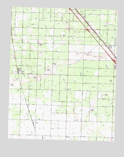
Conejo, CA USGS Topographic Map
Click on map above to begin viewing in our Map Viewer.

This topographic map contains these locations and features:
Feature Name Type Latitude Longitude GNIS ID View Map
A-G Sod FarmsLocaleN36.5119°W119.6819°2558350View Map
Art Gonzales MuseumBuildingN36.5808°W119.6310°1811832View Map
Benight PondLakeN36.5311°W119.6534°219035View Map
Central School (historical)SchoolN36.5177°W119.6649°1665604View Map
Central Valley Aviation Inc AirportAirportN36.5187°W119.6696°1654001View Map
Circle K RanchLocaleN36.6067°W119.6342°2558343View Map
City of FowlerCivilN36.6245°W119.6739°2410538View Map
ConejoPopulated PlaceN36.5183°W119.7190°221448View Map
Conejo Middle SchoolSchoolN36.5188°W119.7137°221449View Map
Crosscut CanalCanalN36.5483°W119.6649°241124View Map
Darby PondBasinN36.5827°W119.6726°222011View Map
Desert Acres RanchLocaleN36.5031°W119.7464°2558346View Map
Dudley PondBasinN36.5575°W119.6321°222695View Map
Duke School (historical)SchoolN36.5033°W119.7101°1665609View Map
Elkhorn DitchCanalN36.5436°W119.7493°223136View Map
Eric White Elementary SchoolSchoolN36.5646°W119.6251°237676View Map
First Friendship Baptist ChurchChurchN36.5691°W119.6285°1811844View Map
Fowler CemeteryCemeteryN36.6113°W119.6834°223768View Map
Helmke PondLakeN36.5705°W119.6982°225152View Map
Iowa DitchCanalN36.6027°W119.6687°225964View Map
Iowa School (historical)SchoolN36.5911°W119.6729°1665630View Map
Kennedy PondLakeN36.5900°W119.7158°226506View Map
Kirby CanalCanalN36.6200°W119.6537°226621View Map
Langstraat FarmLocaleN36.5203°W119.7347°2703418View Map
Leyland FarmsLocaleN36.5258°W119.6956°2558344View Map
Long PondLakeN36.5441°W119.6382°227590View Map
M And K FarmsLocaleN36.5264°W119.6819°2558349View Map
Martin PondLakeN36.5664°W119.7032°228177View Map
McCall SubstationLocaleN36.6111°W119.6396°228278View Map
MonmouthPopulated PlaceN36.5661°W119.7401°1656172View Map
Monmouth Census Designated PlaceCensusN36.5656°W119.7405°2628758View Map
Monmouth Community Presbyterian ChurchChurchN36.5658°W119.7401°1811852View Map
Monroe Elementary SchoolSchoolN36.5643°W119.7363°228928View Map
Nash FarmsLocaleN36.5203°W119.7133°2558345View Map
Nash Farms DairyLocaleN36.5153°W119.7175°2702955View Map
One Thousand Eight Hundred Eighty One DitchCanalN36.5425°W119.6601°230043View Map
Pioneer Village MuseumBuildingN36.5805°W119.6321°1811854View Map
Prather PondLakeN36.5512°W119.7484°231028View Map
Quinn AirportAirportN36.5856°W119.6363°1654003View Map
Ringo ParkParkN36.5625°W119.6251°1811923View Map
Rockwell PondBasinN36.5791°W119.6474°231758View Map
Selma AirportAirportN36.5829°W119.6597°1654002View Map
Selma BranchCanalN36.5336°W119.6351°232797View Map
Selma DivisionCivilN36.5416°W119.6689°1935304View Map
Selma Plaza Shopping CenterLocaleN36.5755°W119.6301°1811867View Map
Terry Elementary SchoolSchoolN36.5479°W119.6819°236131View Map
Weber DitchCanalN36.5533°W119.6860°237383View Map
WildflowerPopulated PlaceN36.5038°W119.6832°252834View Map
Wildflower DitchCanalN36.5319°W119.6743°237812View Map
Willow LakeLakeN36.5589°W119.7227°237920View Map
Young PondLakeN36.5930°W119.6362°1811871View Map

Note: Coordinates in the location and feature list above are referenced to NAD83 datum.


Copyright (C) 2008-2024 Ryan Niemi / Sunset Dynamics ... All Rights Reserved