TopoQuest Logo
Do you find TopoQuest useful?
Help keep TopoQuest running and adding new maps/features by donating!
Home View Maps Find Maps Find Places Resources & Links


Bullock, Alabama Topographic Map

USGS Map Title: Bullock, AL
USGS Map MRC: 31086E2
DRG (GeoTIFF) Download: o31086e2.tif


Neighboring USGS Topographic Map Quads:


  Luverne, AL  
31086F3
 

  Glenwood, AL  
31086F2
 

  Goshen, AL  
31086F1
 

  Brantley, AL  
31086E3
 

  Bullock, AL  
31086E2
 

  Bluff Springs, AL  
31086E1
 

  Dozier, AL  
31086D3
 

  Danleys Crossroads, AL  
31086D2
 

  Elba, AL  
31086D1


Map MRC Location:

N32°
W87°
N32°
W86°
H8 H7 H6 H5 H4 H3 H2 H1
G8 G7 G6 G5 G4 G3 G2 G1
F8 F7 F6 F5 F4 F3 F2 F1
E8 E7 E6 E5 E4 E3 E2 E1
D8 D7 D6 D5 D4 D3 D2 D1
C8 C7 C6 C5 C4 C3 C2 C1
B8 B7 B6 B5 B4 B3 B2 B1
A8 A7 A6 A5 A4 A3 A2 A1
N31°
W87°
N31°
W86°

Bullock, AL USGS 1:24K Topographic Map Preview:
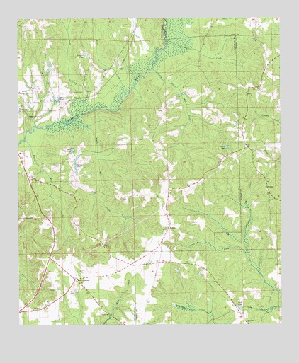
Bullock, AL USGS Topographic Map
Click on map above to begin viewing in our Map Viewer.

This topographic map contains these locations and features:
Feature Name Type Latitude Longitude GNIS ID View Map
Aiken (historical)LocaleN31.58349°W86.23634°133895View Map
Antioch CemeteryCemeteryN31.59599°W86.13661°137055View Map
Antioch Primitive Baptist ChurchChurchN31.59572°W86.13579°149924View Map
Bailey LakesReservoirN31.56799°W86.22219°113357View Map
Beaverdam CemeteryCemeteryN31.50266°W86.14133°137057View Map
Beaverdam Primitive Baptist ChurchChurchN31.50128°W86.14162°149928View Map
Beulah Church (historical)ChurchN31.55600°W86.17606°133901View Map
Blue CreekStreamN31.61544°W86.18051°114532View Map
Bryan Mill CreekStreamN31.58433°W86.22329°115077View Map
Bryans PondReservoirN31.57228°W86.15041°115079View Map
Buck CreekStreamN31.59544°W86.20079°115119View Map
BullockPopulated PlaceN31.54072°W86.17856°156133View Map
Bullock Volunteer Fire DepartmentBuildingN31.54043°W86.17855°2691302View Map
Calvary ChurchChurchN31.55988°W86.24246°115407View Map
Club PondReservoirN31.50727°W86.14505°116290View Map
Coffee Corner Post Office (historical)Post OfficeN31.53600°W86.15662°166052View Map
Driskell Family CemeteryCemeteryN31.51849°W86.15495°137068View Map
Ellis School (historical)SchoolN31.57516°W86.18579°133919View Map
Folmars PondReservoirN31.61010°W86.21774°118467View Map
Friendship ChurchChurchN31.54488°W86.17912°118664View Map
Honey Jones Mill CreekStreamN31.60460°W86.18773°120326View Map
Jones BranchStreamN31.50489°W86.15856°135359View Map
Jones Mill (historical)LocaleN31.53961°W86.22051°133935View Map
Lake NormanReservoirN31.57134°W86.22407°123974View Map
Lowery CemeteryCemeteryN31.50044°W86.14467°132150View Map
Moody Mill CreekStreamN31.57544°W86.24607°122974View Map
Mount Zion ChurchChurchN31.60349°W86.20940°123447View Map
Newbia Baptist ChurchChurchN31.55072°W86.13106°150033View Map
NewbyPopulated PlaceN31.55572°W86.13162°156791View Map
Newby School (historical)SchoolN31.54988°W86.13023°135392View Map
Oak Grove CemeteryCemeteryN31.54460°W86.24689°124064View Map
Old Union ChurchChurchN31.50683°W86.24273°124266View Map
Peacock (historical)Populated PlaceN31.59738°W86.21246°168336View Map
Rainer School (historical)SchoolN31.56405°W86.23662°133964View Map
Sandy CreekStreamN31.58655°W86.21996°126376View Map
Sasser Store (historical)LocaleN31.53766°W86.21829°133971View Map
Sassers Mill ChurchChurchN31.50433°W86.20634°126425View Map
Soldiers Camp CreekStreamN31.53322°W86.14162°127098View Map
Wallaces PondReservoirN31.59162°W86.23145°128541View Map
Weed ChurchChurchN31.50905°W86.23579°128694View Map
Weed CrossroadPopulated PlaceN31.51877°W86.22301°157226View Map
Weed PondReservoirN31.51398°W86.22313°128695View Map
West Fork Pea CreekStreamN31.52933°W86.14051°153942View Map
Zion ChapelChurchN31.51461°W86.23301°155315View Map

Note: Coordinates in the location and feature list above are referenced to NAD83 datum.


Copyright (C) 2008-2026 Ryan Niemi / Sunset Dynamics ... All Rights Reserved
