TopoQuest Logo
Do you find TopoQuest useful?
Help keep TopoQuest running and adding new maps/features by donating!
Home View Maps Find Maps Find Places Resources & Links


Freemanville, Alabama Topographic Map

USGS Map Title: Freemanville, AL
USGS Map MRC: 31087A5
DRG (GeoTIFF) Download: o31087a5.tif


Neighboring USGS Topographic Map Quads:


  Blacksher, AL  
31087B6
 

  McCullough, AL  
31087B5
 

  Huxford, AL  
31087B4
 

  Perdido, AL  
31087A6
 

  Freemanville, AL  
31087A5
 

  Atmore, AL  
31087A4
 

  Dyas, AL  
30087H6
 

  Walnut Hill, FL  
30087H5
 

  Bratt, FL  
30087H4


Map MRC Location:

N32°
W88°
N32°
W87°
H8 H7 H6 H5 H4 H3 H2 H1
G8 G7 G6 G5 G4 G3 G2 G1
F8 F7 F6 F5 F4 F3 F2 F1
E8 E7 E6 E5 E4 E3 E2 E1
D8 D7 D6 D5 D4 D3 D2 D1
C8 C7 C6 C5 C4 C3 C2 C1
B8 B7 B6 B5 B4 B3 B2 B1
A8 A7 A6 A5 A4 A3 A2 A1
N31°
W88°
N31°
W87°

Freemanville, AL USGS 1:24K Topographic Map Preview:
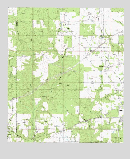
Freemanville, AL USGS Topographic Map
Click on map above to begin viewing in our Map Viewer.

This topographic map contains these locations and features:
Feature Name Type Latitude Longitude GNIS ID View Map
Antioch Number 2 ChurchChurchN31.08157°W87.50859°133739View Map
Atmore Country ClubLocaleN31.01935°W87.53943°133744View Map
Atmore Industrial ParkLocaleN31.02598°W87.52069°2579587View Map
Atmore Wastewater Treatment PlantLocaleN31.01811°W87.51498°2579659View Map
Carney (historical)LocaleN31.09046°W87.52776°133763View Map
Dry BranchStreamN31.03824°W87.53137°117495View Map
Ewing FarmsPopulated PlaceN31.08268°W87.58749°156329View Map
Fletcher CreekStreamN31.03074°W87.59471°118421View Map
FreemanvillePopulated PlaceN31.07185°W87.52082°118629View Map
Freemanville ChurchChurchN31.08157°W87.52748°133798View Map
Freemanville Church CemeteryCemeteryN31.07017°W87.51665°154211View Map
Freemanville Mennonite ChurchChurchN31.05796°W87.51359°133799View Map
Freemanville SchoolSchoolN31.08740°W87.52026°118631View Map
Friendly ChurchChurchN31.12101°W87.52137°126120View Map
Hurricane CreekStreamN31.02824°W87.59610°120580View Map
Judson CemeteryCemeteryN31.11128°W87.56581°133816View Map
Judson ChurchChurchN31.10962°W87.56165°121066View Map
Kingdom Hall of Jehovahs WitnessesChurchN31.02296°W87.50776°133817View Map
Marshall Patterson DamDamN31.03018°W87.52498°129616View Map
Morning Dove ChurchChurchN31.02101°W87.62304°134639View Map
Mount Gillead ChurchChurchN31.08823°W87.52110°133834View Map
Mount GillisPopulated PlaceN31.08907°W87.52221°133835View Map
Mount Shiloh ChurchChurchN31.01935°W87.58554°133838View Map
NokomisPopulated PlaceN31.01018°W87.56471°155179View Map
Nokomis Baptist ChurchChurchN31.00824°W87.57165°133842View Map
Nokomis ChurchChurchN31.00129°W87.55109°133843View Map
Nokomis Church CemeteryCemeteryN31.00795°W87.57220°133844View Map
Nokomis Volunteer Fire DepartmentBuildingN31.00295°W87.59747°2330963View Map
Oak Drive ChurchChurchN31.07157°W87.51276°133846View Map
Patterson LakeReservoirN31.03081°W87.52457°129615View Map
Perdido ChurchChurchN31.01713°W87.62415°134661View Map
Perdido CreekStreamN31.03074°W87.59471°124605View Map
Perdido Hill School (historical)SchoolN31.05907°W87.58415°133851View Map
Perdido Oil FieldOilfieldN31.01185°W87.59860°151186View Map
Perdido SchoolSchoolN31.00523°W87.62253°149403View Map
Pine Level ChurchChurchN31.04629°W87.50693°124828View Map
PoarchPopulated PlaceN31.11740°W87.52943°156913View Map
Poarch Community ChurchChurchN31.10157°W87.55499°133864View Map
Poarch Creek MuseumBuildingN31.11943°W87.56464°2579882View Map
Poarch Creek ReservationCivilN31.10138°W87.56242°2419057View Map
Poarch Mission CemeteryCemeteryN31.12100°W87.51248°133862View Map
Poarch Mission ChurchChurchN31.12101°W87.51276°133863View Map
Poarch Tribal Police DepartmentBuildingN31.10122°W87.55590°2751926View Map
Poarch Volunteer Fire DepartmentBuildingN31.09815°W87.55381°2331027View Map
Raley Forest HillPopulated PlaceN31.01129°W87.51109°133866View Map
Rocky BranchStreamN31.05157°W87.57415°125797View Map
Saint Annas ChurchChurchN31.10490°W87.55971°133870View Map
Saint Thomas African Methodist Episcopal Zion Methodist ChurchChurchN31.01580°W87.62358°2580515View Map
Sturdy Oak Farm AirportAirportN31.03448°W87.59478°2676334View Map
Sullivan CemeteryCemeteryN31.00462°W87.59554°153601View Map
Swift Westside Baptist ChurchChurchN31.03185°W87.50498°133883View Map
Turkeypen BranchStreamN31.08935°W87.60221°128177View Map
WASG-AM (Atmore)TowerN31.00740°W87.53748°160914View Map
West End ChurchChurchN31.01824°W87.52332°163144View Map
West Spring BranchStreamN31.07629°W87.56721°128803View Map

Note: Coordinates in the location and feature list above are referenced to NAD83 datum.


Copyright (C) 2008-2026 Ryan Niemi / Sunset Dynamics ... All Rights Reserved
