TopoQuest Logo
Do you find TopoQuest useful?
Help keep TopoQuest running and adding new maps/features by donating!
Home View Maps Find Maps Find Places Resources & Links


Rockford, Alabama Topographic Map

USGS Map Title: Rockford, AL
USGS Map MRC: 32086H2
DRG (GeoTIFF) Download: o32086h2.tif


Neighboring USGS Topographic Map Quads:


  Weogufka, AL  
33086A3
 

  Hollins, AL  
33086A2
 

  Goodwater, AL  
33086A1
 

  Flag Mountain, AL  
32086H3
 

  Rockford, AL  
32086H2
 

  Kellyton, AL  
32086H1
 

  Richville, AL  
32086G3
 

  Rockford SW, AL  
32086G2
 

  Equality, AL  
32086G1


Map MRC Location:

N33°
W87°
N33°
W86°
H8 H7 H6 H5 H4 H3 H2 H1
G8 G7 G6 G5 G4 G3 G2 G1
F8 F7 F6 F5 F4 F3 F2 F1
E8 E7 E6 E5 E4 E3 E2 E1
D8 D7 D6 D5 D4 D3 D2 D1
C8 C7 C6 C5 C4 C3 C2 C1
B8 B7 B6 B5 B4 B3 B2 B1
A8 A7 A6 A5 A4 A3 A2 A1
N32°
W87°
N32°
W86°

Rockford, AL USGS 1:24K Topographic Map Preview:
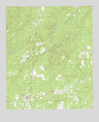
Rockford, AL USGS Topographic Map
Click on map above to begin viewing in our Map Viewer.

This topographic map contains these locations and features:
Feature Name Type Latitude Longitude GNIS ID View Map
Adams Elementary SchoolSchoolN32.89457°W86.22775°135651View Map
Buford BranchStreamN32.93596°W86.22581°115161View Map
Church of ChristChurchN32.88040°W86.22442°116125View Map
Concord CemeteryCemeteryN32.89706°W86.14996°135670View Map
Concord Methodist ChurchChurchN32.89679°W86.14997°164042View Map
Coosa CountyCivilN32.93623°W86.24766°161544View Map
Coosa County CourthouseBuildingN32.88957°W86.21969°1959552View Map
Coosa County High SchoolSchoolN32.88873°W86.22219°135672View Map
Coosa County Saddle ClubLocaleN32.88901°W86.14497°135673View Map
Coosa County Sheriff's OfficeBuildingN32.88970°W86.22119°2752007View Map
CrewsvillePopulated PlaceN32.94346°W86.13664°156225View Map
Darsey CemeteryCemeteryN32.90540°W86.14913°117081View Map
Davidson CreekStreamN32.94151°W86.18080°117096View Map
Dunlaps LakeReservoirN32.89798°W86.16652°135676View Map
Elmer Dunnam DamDamN32.99845°W86.14830°131138View Map
Hanover Volunteer Fire DepartmentBuildingN32.99421°W86.20102°2691440View Map
HissopPopulated PlaceN32.89235°W86.15330°120154View Map
Hissop Post OfficePost OfficeN32.89235°W86.15302°168302View Map
Howard CemeteryCemeteryN32.89956°W86.14052°163401View Map
Howards PondReservoirN32.89689°W86.17714°135693View Map
J S Dunlap DamDamN32.90012°W86.15830°131087View Map
Jacks CreekStreamN32.94429°W86.18303°120754View Map
Little Jacks CreekStreamN32.93596°W86.15886°121805View Map
McEwen CemeteryCemeteryN32.92067°W86.21191°1802750View Map
McEwen CemeteryCemeteryN32.92039°W86.21163°164175View Map
McEwen SpringSpringN32.93831°W86.21340°122537View Map
Meadow BranchStreamN32.96818°W86.24914°122612View Map
Mill CreekStreamN32.98068°W86.16636°160102View Map
Miller-Patterson CemeteryCemeteryN32.93956°W86.23608°122836View Map
New Home ChurchChurchN32.87790°W86.14386°123771View Map
Old Coosa County JailBuildingN32.88985°W86.21969°1959586View Map
Old Rockford CemeteryCemeteryN32.89040°W86.23136°135719View Map
Poplar Springs Baptist ChurchChurchN32.97234°W86.22386°158060View Map
Poplar Springs CemeteryCemeteryN32.97123°W86.22469°135727View Map
RockfordPopulated PlaceN32.88957°W86.21969°153189View Map
Rockford CemeteryCemeteryN32.89095°W86.22497°135731View Map
Rockford Methodist CemeteryCemeteryN32.89456°W86.22830°135732View Map
Rockford Methodist ChurchChurchN32.89429°W86.22886°153190View Map
Rockford Police DepartmentBuildingN32.88947°W86.21976°2752039View Map
Rockford Post OfficePost OfficeN32.88953°W86.22073°168303View Map
Rockford Volunteer Fire DepartmentBuildingN32.88262°W86.22169°2691113View Map
Sears Chapel Methodist ChurchChurchN32.92096°W86.21219°153360View Map
Shady Grove ChurchChurchN32.98151°W86.20719°126609View Map
Socapatoy CreekStreamN32.94818°W86.19053°160642View Map
Thomas ProspectMineN32.90318°W86.14191°157680View Map
Town of RockfordCivilN32.88957°W86.21501°2407230View Map

Note: Coordinates in the location and feature list above are referenced to NAD83 datum.


Copyright (C) 2008-2026 Ryan Niemi / Sunset Dynamics ... All Rights Reserved
