TopoQuest Logo
Do you find TopoQuest useful?
Help keep TopoQuest running and adding new maps/features by donating!
Home View Maps Find Maps Find Places Resources & Links


Gould, Arkansas Topographic Map

USGS Map Title: Gould, AR
USGS Map MRC: 33091H5
DRG (GeoTIFF) Download: o33091h5.tif


Neighboring USGS Topographic Map Quads:


  Grady, AR  
34091A6
 

  Cades, AR  
34091A5
 

  Gillett, AR  
34091A4
 

  Avery, AR  
33091H6
 

  Gould, AR  
33091H5
 

  Dumas, AR  
33091H4
 

  Tyro, AR  
33091G6
 

  Gourd, AR  
33091G5
 

  Winchester, AR  
33091G4


Map MRC Location:

N34°
W92°
N34°
W91°
H8 H7 H6 H5 H4 H3 H2 H1
G8 G7 G6 G5 G4 G3 G2 G1
F8 F7 F6 F5 F4 F3 F2 F1
E8 E7 E6 E5 E4 E3 E2 E1
D8 D7 D6 D5 D4 D3 D2 D1
C8 C7 C6 C5 C4 C3 C2 C1
B8 B7 B6 B5 B4 B3 B2 B1
A8 A7 A6 A5 A4 A3 A2 A1
N33°
W92°
N33°
W91°

Gould, AR USGS 1:24K Topographic Map Preview:
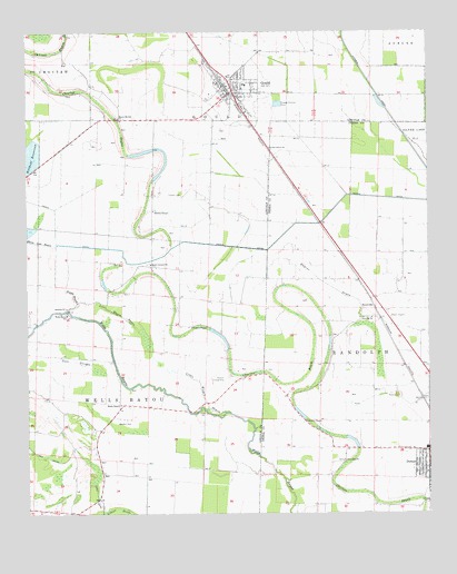
Gould, AR USGS Topographic Map
Click on map above to begin viewing in our Map Viewer.

This topographic map contains these locations and features:
Feature Name Type Latitude Longitude GNIS ID View Map
Almetta ChurchChurchN33.92566°W91.51790°45841View Map
Bailey Chapel Church (historical)ChurchN33.95371°W91.58568°60318View Map
Banks CemeteryCemeteryN33.90537°W91.50928°46077View Map
Billy Free Municipal AirportAirportN33.88548°W91.53308°83683View Map
Choctaw BayouGutN33.99510°W91.61652°47762View Map
City of GouldCivilN33.98714°W91.56406°2403718View Map
Curry BrakeSwampN33.92398°W91.52030°63774View Map
Dark Corner School (historical)SchoolN33.93982°W91.58651°60320View Map
Dark Corners ChurchChurchN33.93982°W91.58679°76748View Map
Eugene BayouGutN33.93566°W91.53401°48924View Map
FlynnPopulated PlaceN33.97093°W91.58540°60319View Map
Gibson BrakeGutN33.87649°W91.59735°49392View Map
GouldPopulated PlaceN33.98510°W91.56096°77045View Map
Gould Elementary SchoolSchoolN33.98706°W91.56649°60321View Map
Gould Fire Department StationBuildingN33.98849°W91.56371°2116491View Map
Gould High SchoolSchoolN33.98599°W91.55729°60322View Map
Gould Middle SchoolSchoolN33.98615°W91.55646°2039324View Map
Gould Police DepartmentBuildingN33.98885°W91.56450°2118654View Map
Holthoff ReservoirReservoirN33.96816°W91.62096°74901View Map
Hudson Landing Strip (historical)AirportN33.90927°W91.56429°64061View Map
KDDA-AM (Dumas)TowerN33.89094°W91.52735°85298View Map
Kerch CanalCanalN33.95038°W91.61624°50823View Map
KXFE-FM (Dumas)TowerN33.89094°W91.52735°85382View Map
Ladd CanalCanalN33.89094°W91.62318°50933View Map
Little Wagon BayouGutN33.90121°W91.56374°51336View Map
Little Wagon BayouGutN33.92760°W91.59901°51337View Map
Madden CemeteryCemeteryN33.89871°W91.59706°51596View Map
Mayer Airport (historical)AirportN33.92538°W91.51179°63769View Map
MillsPopulated PlaceN33.92788°W91.57790°64071View Map
Mount Moriah ChurchChurchN33.97760°W91.59651°77721View Map
Oems Free Gift ChurchChurchN33.88871°W91.52651°52976View Map
Parma (historical)Populated PlaceN33.96538°W91.54596°63790View Map
Rankin Chapel Baptist ChurchChurchN33.89871°W91.53874°78133View Map
ReedvillePopulated PlaceN33.93038°W91.51846°78154View Map
Reedville Airport (historical)AirportN33.92510°W91.51123°83682View Map
Reedville School (historical)SchoolN33.92344°W91.52596°63777View Map
RotanPopulated PlaceN33.96732°W91.54762°63778View Map
Smyrna Missionary Baptist ChurchChurchN33.92844°W91.61318°54967View Map
Thomas CemeteryCemeteryN33.95760°W91.57706°55522View Map
Thomas ChapelChurchN33.95371°W91.58568°78543View Map
Township of GouldCivilN33.99115°W91.56624°66823View Map
Township of RandolphCivilN33.91405°W91.50821°66503View Map
Township of Wells BayouCivilN33.90712°W91.62362°66830View Map
Twin SloughsGutN33.91455°W91.61068°55759View Map
Union Grove ChurchChurchN33.96982°W91.54929°78616View Map
Wagon BayouGutN33.93121°W91.61096°55938View Map
Watson ChapelChurchN33.92344°W91.57401°56110View Map
Wells BayouGutN33.88566°W91.54846°78716View Map
Wells Bayou SchoolSchoolN33.92677°W91.61290°56144View Map
Wells ChapelChurchN33.90344°W91.59651°56149View Map
West Dumas Church of God in ChristChurchN33.88760°W91.50290°63791View Map

Note: Coordinates in the location and feature list above are referenced to NAD83 datum.


Copyright (C) 2008-2026 Ryan Niemi / Sunset Dynamics ... All Rights Reserved
