TopoQuest Logo
Do you find TopoQuest useful?
Help keep TopoQuest running and adding new maps/features by donating!
Home View Maps Find Maps Find Places Resources & Links


Tarboro, Georgia Topographic Map

USGS Map Title: Tarboro, GA
USGS Map MRC: 31081A7
DRG (GeoTIFF) Download: o31081a7.tif


Neighboring USGS Topographic Map Quads:


  Nahunta, GA  
31081B8
 

  Waynesville, GA  
31081B7
 

  Bladen, GA  
31081B6
 

  Boons Lake, GA  
31081A8
 

  Tarboro, GA  
31081A7
 

  Waverly, GA  
31081A6
 

  Burnt Fort, GA  
30081H8
 

  Jerusalem, GA  
30081H7
 

  Woodbine, GA  
30081H6


Map MRC Location:

N32°
W82°
N32°
W81°
H8 H7 H6 H5 H4 H3 H2 H1
G8 G7 G6 G5 G4 G3 G2 G1
F8 F7 F6 F5 F4 F3 F2 F1
E8 E7 E6 E5 E4 E3 E2 E1
D8 D7 D6 D5 D4 D3 D2 D1
C8 C7 C6 C5 C4 C3 C2 C1
B8 B7 B6 B5 B4 B3 B2 B1
A8 A7 A6 A5 A4 A3 A2 A1
N31°
W82°
N31°
W81°

Tarboro, GA USGS 1:24K Topographic Map Preview:
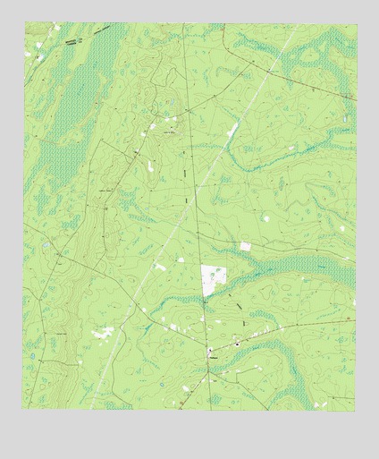
Tarboro, GA USGS Topographic Map
Click on map above to begin viewing in our Map Viewer.

This topographic map contains these locations and features:
Feature Name Type Latitude Longitude GNIS ID View Map
Bickley ChapelChurchN31.04717°W81.86178°354706View Map
Bixley Chapel (historical)ChurchN31.04967°W81.86094°334951View Map
Brown ChapelChurchN31.02245°W81.80539°311862View Map
Camden County Fire Rescue Station 18BuildingN31.02317°W81.80619°2603958View Map
Clarke School (historical)SchoolN31.07884°W81.82622°334952View Map
Clinchs ChapelChurchN31.01051°W81.80428°312751View Map
Goldsborough (historical)Populated PlaceN31.03551°W81.86844°1671350View Map
Harrell CemeteryCemeteryN31.02467°W81.86205°315170View Map
Idlewild Plantation (historical)LocaleN31.04523°W81.84872°1671364View Map
Incachee Plantation (historical)LocaleN31.09273°W81.81705°1671365View Map
Kings BaySwampN31.11626°W81.84825°316440View Map
Oak Grove ChurchChurchN31.02912°W81.80678°319759View Map
Providence ChurchChurchN31.05773°W81.80900°321185View Map
Redcap SwampSwampN31.11523°W81.77678°321414View Map
TarboroPopulated PlaceN31.01773°W81.80539°333189View Map
Tower SwampSwampN31.00210°W81.76744°324238View Map
Victory CemeteryCemeteryN31.04689°W81.86205°1671305View Map
Waverly SwampSwampN31.08456°W81.76764°324931View Map
White Oak SwampSwampN31.04662°W81.77483°326144View Map
Zion Rock ChurchChurchN31.02329°W81.80567°1671439View Map

Note: Coordinates in the location and feature list above are referenced to NAD83 datum.


Copyright (C) 2008-2026 Ryan Niemi / Sunset Dynamics ... All Rights Reserved
