TopoQuest Logo
Do you find TopoQuest useful?
Help keep TopoQuest running and adding new maps/features by donating!
Home View Maps Find Maps Find Places Resources & Links


Dolliver, Iowa Topographic Map

USGS Map Title: Dolliver, IA
USGS Map MRC: 43094D5
DRG (GeoTIFF) Download: o43094d5.tif


Neighboring USGS Topographic Map Quads:


  Ceylon, MN  
43094E6
 

  Wilbert, MN  
43094E5
 

  Wilmert Lake, MN  
43094E4
 

  Gruver, IA  
43094D6
 

  Dolliver, IA  
43094D5
 

  Armstrong, IA  
43094D4
 

  Ingham Lake, IA  
43094C6
 

  Ringsted, IA  
43094C5
 

  Seneca, IA  
43094C4


Map MRC Location:

N44°
W95°
N44°
W94°
H8 H7 H6 H5 H4 H3 H2 H1
G8 G7 G6 G5 G4 G3 G2 G1
F8 F7 F6 F5 F4 F3 F2 F1
E8 E7 E6 E5 E4 E3 E2 E1
D8 D7 D6 D5 D4 D3 D2 D1
C8 C7 C6 C5 C4 C3 C2 C1
B8 B7 B6 B5 B4 B3 B2 B1
A8 A7 A6 A5 A4 A3 A2 A1
N43°
W95°
N43°
W94°

Dolliver, IA USGS 1:24K Topographic Map Preview:
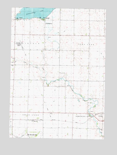
Dolliver, IA USGS Topographic Map
Click on map above to begin viewing in our Map Viewer.

This topographic map contains these locations and features:
Feature Name Type Latitude Longitude GNIS ID View Map
Armstrong Grove CemeteryCemeteryN43.39911°W94.50336°1823508View Map
City of DolliverCivilN43.46384°W94.61432°2394541View Map
Ditch Number 26CanalN43.41746°W94.56664°1823107View Map
Ditch Number 68CanalN43.47718°W94.55581°1823106View Map
Dolliver (historical)LocaleN43.46523°W94.61165°1907485View Map
Dolliver Post OfficePost OfficeN43.46514°W94.61307°1907509View Map
Ellsworth Ranch BridgeBridgeN43.46051°W94.58026°1907506View Map
GridleyPopulated PlaceN43.39940°W94.57331°464037View Map
Gridley (historical)LocaleN43.39940°W94.57331°1907422View Map
Gridley Post Office (historical)Post OfficeN43.39940°W94.57331°1907421View Map
Gruver Fire Department Station 2BuildingN43.46562°W94.61376°2577340View Map
Guse FarmsLocaleN43.40750°W94.62470°2729835View Map
Lincoln Township CemeteryCemeteryN43.44441°W94.62078°1823169View Map
Maple HillLocaleN43.39274°W94.59470°1907411View Map
Maple Hill Post Office (historical)Post OfficeN43.39163°W94.59470°1907508View Map
Mount Calvary CemeteryCemeteryN43.38496°W94.50274°1823507View Map
Okamanpeedan LakeReservoirN43.49621°W94.58580°459814View Map
Okomanpado Lake Historical MarkerParkN43.48885°W94.58303°1907429View Map
Saint Marys Catholic CemeteryCemeteryN43.38496°W94.50274°1907498View Map
Township of Armstrong GroveCivilN43.38632°W94.50160°467399View Map
Township of Iowa LakeCivilN43.46555°W94.50163°468087View Map
Township of LincolnCivilN43.46556°W94.61973°468248View Map
Township of Swan LakeCivilN43.38622°W94.61977°468771View Map
Tuttle Lake County ParkParkN43.48857°W94.61692°1823108View Map
Tuttle Lake State Game Management AreaParkN43.48468°W94.57637°1823109View Map

Note: Coordinates in the location and feature list above are referenced to NAD83 datum.


Copyright (C) 2008-2026 Ryan Niemi / Sunset Dynamics ... All Rights Reserved
