TopoQuest Logo
Do you find TopoQuest useful?
Help keep TopoQuest running and adding new maps/features by donating!
Home View Maps Find Maps Find Places Resources & Links


Calhoun, Kentucky Topographic Map

USGS Map Title: Calhoun, KY
USGS Map MRC: 37087E3
DRG (GeoTIFF) Download: o37087e3.tif


Neighboring USGS Topographic Map Quads:


  Delaware, KY  
37087F4
 

  Curdsville, KY  
37087F3
 

  Panther, KY  
37087F2
 

  Beech Grove, KY  
37087E4
 

  Calhoun, KY  
37087E3
 

  Glenville, KY  
37087E2
 

  Hanson, KY  
37087D4
 

  Sacramento, KY  
37087D3
 

  Livermore, KY  
37087D2


Map MRC Location:

N38°
W88°
N38°
W87°
H8 H7 H6 H5 H4 H3 H2 H1
G8 G7 G6 G5 G4 G3 G2 G1
F8 F7 F6 F5 F4 F3 F2 F1
E8 E7 E6 E5 E4 E3 E2 E1
D8 D7 D6 D5 D4 D3 D2 D1
C8 C7 C6 C5 C4 C3 C2 C1
B8 B7 B6 B5 B4 B3 B2 B1
A8 A7 A6 A5 A4 A3 A2 A1
N37°
W88°
N37°
W87°

Calhoun, KY USGS 1:24K Topographic Map Preview:
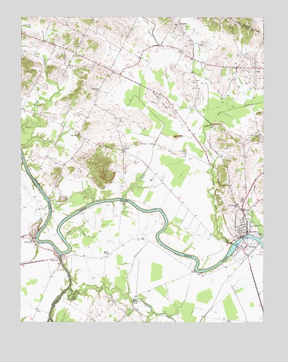
Calhoun, KY USGS Topographic Map
Click on map above to begin viewing in our Map Viewer.

This topographic map contains these locations and features:
Feature Name Type Latitude Longitude GNIS ID View Map
Antioch ChurchChurchN37.59532°W87.33472°485986View Map
AshbyburgPopulated PlaceN37.53532°W87.36889°486078View Map
CalhounPopulated PlaceN37.53894°W87.25833°488604View Map
Calhoun CemeteryCemeteryN37.55143°W87.25972°488607View Map
Calhoun City Fire DepartmentBuildingN37.53687°W87.25958°2637331View Map
Calhoun DivisionCivilN37.58424°W87.32552°1936907View Map
Cave CreekStreamN37.55057°W87.32255°2743112View Map
Charles Hansford Historical MarkerParkN37.54972°W87.26017°2744601View Map
City of CalhounCivilN37.54108°W87.25958°2403966View Map
CleopatraPopulated PlaceN37.62227°W87.29278°507714View Map
Corporal James Bethel Gresham Memorial Bridge Historical MarkerParkN37.52983°W87.26022°2744597View Map
Cypress CreekStreamN37.51393°W87.34972°490526View Map
Eagle CreekStreamN37.53393°W87.35194°491405View Map
General Forrest Reconnaissance Historical MarkerParkN37.53680°W87.26074°2744602View Map
Glovers (historical)Populated PlaceN37.60379°W87.32972°2743117View Map
Gravel Ford BridgeBridgeN37.50921°W87.31694°493177View Map
GuffiePopulated PlaceN37.60421°W87.25444°508145View Map
Jewel CityPopulated PlaceN37.52643°W87.35528°508344View Map
Johnson IslandSummitN37.59116°W87.30194°495416View Map
Johnson IslandPopulated PlaceN37.59376°W87.30371°2743118View Map
Leachman (historical)Populated PlaceN37.61240°W87.30839°2743119View Map
Lock Number 2DamN37.53171°W87.26361°517222View Map
Long Falls CreekStreamN37.53227°W87.26583°497098View Map
Mayo Hills (historical)Populated PlaceN37.57400°W87.25338°2743121View Map
McLean CountyCivilN37.52919°W87.26361°516927View Map
McLean County Ambulance ServiceBuildingN37.54868°W87.25959°2719141View Map
McLean County Central District Fire DepartmentBuildingN37.53768°W87.25738°2637061View Map
McLean County Historical MarkerParkN37.53730°W87.25818°2744600View Map
McLean County Sheriff's OfficeBuildingN37.53747°W87.25787°2767428View Map
Moseley FieldAirportN37.59346°W87.28124°2444074View Map
Mount VernonPopulated PlaceN37.58060°W87.35435°2743122View Map
Mount Vernon Baptist ChurchChurchN37.57645°W87.34498°498895View Map
Myer CreekStreamN37.53421°W87.25194°499145View Map
Otter CreekStreamN37.50171°W87.35972°500023View Map
Pitman CreekStreamN37.56616°W87.37389°500777View Map
Pond RiverStreamN37.52727°W87.35417°501053View Map
PovertyPopulated PlaceN37.57088°W87.32111°508866View Map
RumseyPopulated PlaceN37.53199°W87.25805°502467View Map
Rumsey Census Designated PlaceCensusN37.52755°W87.26029°2629676View Map
Rumsey Historical MarkerParkN37.52980°W87.26010°2744598View Map
Saint Sebastian SchoolSchoolN37.54894°W87.26278°502738View Map
Shutts (historical)Populated PlaceN37.52766°W87.32942°2743128View Map
Shutts ChapelChurchN37.52838°W87.32861°503479View Map
Smith Airport (historical)AirportN37.61338°W87.26305°517349View Map
The BendBendN37.53393°W87.35865°2743132View Map
Tichenor HillsRangeN37.56448°W87.33436°2743133View Map
Woosley AirportAirportN37.50032°W87.33023°517481View Map
Woosley FieldAirportN37.55254°W87.27140°517348View Map

Note: Coordinates in the location and feature list above are referenced to NAD83 datum.


Copyright (C) 2008-2026 Ryan Niemi / Sunset Dynamics ... All Rights Reserved
