TopoQuest Logo
Do you find TopoQuest useful?
Help keep TopoQuest running and adding new maps/features by donating!
Home View Maps Find Maps Find Places Resources & Links


Providence, Kentucky Topographic Map

USGS Map Title: Providence, KY
USGS Map MRC: 37087D7
DRG (GeoTIFF) Download: o37087d7.tif


Neighboring USGS Topographic Map Quads:


  Sturgis, KY  
37087E8
 

  Bordley, KY  
37087E7
 

  Dixon, KY  
37087E6
 

  Blackford, KY  
37087D8
 

  Providence, KY  
37087D7
 

  Nebo, KY  
37087D6
 

  Shady Grove, KY  
37087C8
 

  Dalton, KY  
37087C7
 

  Coiltown, KY  
37087C6


Map MRC Location:

N38°
W88°
N38°
W87°
H8 H7 H6 H5 H4 H3 H2 H1
G8 G7 G6 G5 G4 G3 G2 G1
F8 F7 F6 F5 F4 F3 F2 F1
E8 E7 E6 E5 E4 E3 E2 E1
D8 D7 D6 D5 D4 D3 D2 D1
C8 C7 C6 C5 C4 C3 C2 C1
B8 B7 B6 B5 B4 B3 B2 B1
A8 A7 A6 A5 A4 A3 A2 A1
N37°
W88°
N37°
W87°

Providence, KY USGS 1:24K Topographic Map Preview:
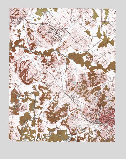
Providence, KY USGS Topographic Map
Click on map above to begin viewing in our Map Viewer.

This topographic map contains these locations and features:
Feature Name Type Latitude Longitude GNIS ID View Map
Bald HillSummitN37.40449°W87.85891°486259View Map
BellvillePopulated PlaceN37.38171°W87.79918°507491View Map
Big Hill CemeteryCemeteryN37.40333°W87.76100°487184View Map
Blackwell CemeteryCemeteryN37.47103°W87.82311°487426View Map
Caney ForkStreamN37.46366°W87.86668°488863View Map
Cedar Street High SchoolSchoolN37.39671°W87.76612°489250View Map
City of ClayCivilN37.47629°W87.82026°2404064View Map
City of ProvidenceCivilN37.39935°W87.75094°2404576View Map
City of WheatcroftCivilN37.48927°W87.86119°2405725View Map
Clark DitchCanalN37.46671°W87.77251°489538View Map
ClayPopulated PlaceN37.47671°W87.82002°489565View Map
Clay DivisionCivilN37.48100°W87.85095°1936935View Map
Clay Fire DepartmentBuildingN37.47714°W87.82045°2637066View Map
Clay Police DepartmentBuildingN37.47710°W87.82045°2767669View Map
Clifty HillSummitN37.44893°W87.81279°489687View Map
Clifty MineMineN37.45227°W87.81113°489690View Map
Cullen CemeteryCemeteryN37.41397°W87.77506°490464View Map
Cumberland ChurchChurchN37.39671°W87.75890°490472View Map
DiamondPopulated PlaceN37.41671°W87.80224°490858View Map
Diamond MinesMineN37.42171°W87.79640°490864View Map
Dorris CemeteryCemeteryN37.40204°W87.77040°491003View Map
Douven MineMineN37.41449°W87.75723°491065View Map
Elm Grove ChurchChurchN37.42754°W87.75279°491730View Map
FairmontPopulated PlaceN37.46005°W87.85002°507970View Map
Fairmont MinesMineN37.46366°W87.84946°491886View Map
Fraser - Blackwell CemeteryCemeteryN37.43931°W87.81673°492472View Map
Fredricks ChapelChurchN37.45866°W87.75751°492489View Map
Fredricks DitchCanalN37.45893°W87.77696°492490View Map
Green Grove ChurchChurchN37.39921°W87.80779°493270View Map
Green Grove HillSummitN37.39893°W87.81751°493271View Map
I N Baker DitchCanalN37.44588°W87.77279°494874View Map
Johnson CemeteryCemeteryN37.40087°W87.87196°495379View Map
Johnson CemeteryCemeteryN37.43170°W87.78890°495380View Map
Johnson MinesMineN37.43449°W87.86168°495422View Map
Lanaham MineMineN37.42838°W87.85391°495945View Map
Mine Number 10MineN37.47449°W87.85335°517240View Map
Mine Number 4MineN37.48588°W87.86752°517241View Map
Mine Number 5MineN37.48393°W87.83946°517242View Map
Montezuma BridgeBridgeN37.39671°W87.84474°498497View Map
Montezuma MineMineN37.39421°W87.81835°498498View Map
Mount Olivet (historical)Populated PlaceN37.41080°W87.85342°2743696View Map
Nesbit HillSummitN37.44810°W87.82279°499267View Map
New Hopewell ChurchChurchN37.44032°W87.86391°499363View Map
Odd Fellows CemeteryCemeteryN37.47954°W87.81044°499770View Map
Owens CreekStreamN37.37866°W87.80085°500073View Map
Pleasant Hill ChurchChurchN37.40171°W87.75501°500866View Map
ProvidencePopulated PlaceN37.39755°W87.76279°501368View Map
Providence City LakeReservoirN37.38622°W87.78753°501380View Map
Providence DivisionCivilN37.42590°W87.76193°1937212View Map
Providence Fire DepartmentBuildingN37.39921°W87.76155°2636513View Map
Providence Police DepartmentBuildingN37.39933°W87.76114°2767499View Map
Rock Springs CemeteryCemeteryN37.49365°W87.87446°499321View Map
Rosenwald SchoolSchoolN37.40254°W87.75529°502352View Map
Shaft Number 7MineN37.49449°W87.83252°517281View Map
Slover CreekStreamN37.45477°W87.80724°503714View Map
South Broadway SchoolSchoolN37.39310°W87.75946°503894View Map
Tigg MineMineN37.40366°W87.83001°505276View Map
Tulno MineMineN37.43199°W87.80335°505563View Map
Union ChurchChurchN37.40199°W87.78029°505782View Map
Vaughn MineMineN37.44227°W87.86696°505999View Map
Victory ChurchChurchN37.39227°W87.75835°506043View Map
W L Baker DitchCanalN37.45727°W87.83446°506076View Map
West WheatcroftPopulated PlaceN37.48810°W87.87113°506483View Map
WheatcroftPopulated PlaceN37.49005°W87.86280°506516View Map
Wheatcroft Fire DepartmentBuildingN37.48943°W87.86274°2637064View Map
White Oak ChurchChurchN37.42838°W87.82946°506606View Map
Whiteside CreekStreamN37.38755°W87.81724°506680View Map
WHRZ-FM (Providence)TowerN37.40977°W87.77557°518014View Map
Williams CemeteryCemeteryN37.38698°W87.87168°506800View Map
Wolf CreekStreamN37.37782°W87.85529°506998View Map
Wynn CemeteryCemeteryN37.39793°W87.82686°507181View Map

Note: Coordinates in the location and feature list above are referenced to NAD83 datum.


Copyright (C) 2008-2026 Ryan Niemi / Sunset Dynamics ... All Rights Reserved
