TopoQuest Logo
Do you find TopoQuest useful?
Help keep TopoQuest running and adding new maps/features by donating!
Home View Maps Find Maps Find Places Resources & Links


Salem, Kentucky Topographic Map

USGS Map Title: Salem, KY
USGS Map MRC: 37088C2
DRG (GeoTIFF) Download: o37088c2.tif


Neighboring USGS Topographic Map Quads:


  Rosiclare, IL  
37088D3
 

  Cave-in-Rock, IL  
37088D2
 

  Repton, KY  
37088D1
 

  Lola, KY  
37088C3
 

  Salem, KY  
37088C2
 

  Marion, KY  
37088C1
 

  Burna, KY  
37088B3
 

  Dycusburg, KY  
37088B2
 

  Fredonia, KY  
37088B1


Map MRC Location:

N38°
W89°
N38°
W88°
H8 H7 H6 H5 H4 H3 H2 H1
G8 G7 G6 G5 G4 G3 G2 G1
F8 F7 F6 F5 F4 F3 F2 F1
E8 E7 E6 E5 E4 E3 E2 E1
D8 D7 D6 D5 D4 D3 D2 D1
C8 C7 C6 C5 C4 C3 C2 C1
B8 B7 B6 B5 B4 B3 B2 B1
A8 A7 A6 A5 A4 A3 A2 A1
N37°
W89°
N37°
W88°

Salem, KY USGS 1:24K Topographic Map Preview:
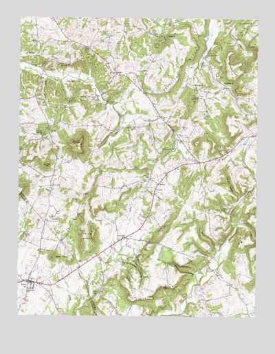
Salem, KY USGS Topographic Map
Click on map above to begin viewing in our Map Viewer.

This topographic map contains these locations and features:
Feature Name Type Latitude Longitude GNIS ID View Map
Ada Florence MineMineN37.32616°W88.16503°485747View Map
Atlas MineMineN37.34172°W88.21697°486124View Map
Babb MineMineN37.28366°W88.24559°486170View Map
Bebout MineMineN37.35283°W88.18420°486638View Map
Big Four MineMineN37.33839°W88.20531°487177View Map
Brown HollowValleyN37.27778°W88.14477°488006View Map
Buck BranchStreamN37.35033°W88.23503°488188View Map
Butler MinesMineN37.34811°W88.22281°488517View Map
Cave HillSummitN37.31339°W88.23559°489121View Map
Childress BluffCliffN37.27533°W88.15364°489473View Map
City of SalemCivilN37.26524°W88.24096°2405405View Map
Clement CreekStreamN37.25589°W88.16003°489653View Map
Clement MineMineN37.36061°W88.15086°489654View Map
Clifty HollowValleyN37.26647°W88.15648°489688View Map
Columbia MineMineN37.34700°W88.15753°489886View Map
Commodore MineMineN37.37200°W88.17114°489909View Map
Corn BranchStreamN37.34894°W88.22809°490113View Map
Corn MineMineN37.32616°W88.23836°490118View Map
Crittenden SpringSpringN37.35987°W88.15128°490357View Map
Crittenden Spring SchoolSchoolN37.34838°W88.14225°490358View Map
Crodson CreekStreamN37.26533°W88.21281°490360View Map
Crodson SpringSpringN37.27298°W88.21883°490361View Map
Crystal MinesMineN37.34061°W88.21003°490438View Map
Davenport MineMineN37.27255°W88.19225°490618View Map
Deer Creek ChurchChurchN37.36200°W88.21614°490772View Map
Dell-High MineMineN37.28950°W88.23420°490798View Map
Dry Fork CreekStreamN37.27672°W88.19669°491215View Map
Eagle-Babb MineMineN37.29144°W88.23086°491413View Map
Eberle KnobsSummitN37.27505°W88.23114°491543View Map
Franklin MinesMineN37.32894°W88.16308°492455View Map
Glendale (historical)Populated PlaceN37.36784°W88.17318°2743689View Map
Glendale ChurchChurchN37.36783°W88.17225°492894View Map
Glendale MinesMineN37.36394°W88.17642°492896View Map
Gorn SchoolSchoolN37.32727°W88.23392°493036View Map
Gray MineMineN37.35505°W88.22781°493204View Map
Griffith BluffCliffN37.35505°W88.16392°493385View Map
Hardin KnobSummitN37.32200°W88.21836°493722View Map
Hickory Cane MineMineN37.36783°W88.17503°494119View Map
Hilltop ChurchChurchN37.32839°W88.19114°494280View Map
Holly MineMineN37.34061°W88.21642°494413View Map
Horse Lot MineMineN37.34394°W88.20586°494581View Map
Hurricane HollowValleyN37.27322°W88.19318°494837View Map
Jim Belt MineMineN37.31866°W88.24948°495261View Map
John Thomas BluffCliffN37.35505°W88.13836°495336View Map
K K MinesMineN37.35977°W88.18058°495561View Map
Keystone Mine and Fluorite Floatation MillMineN37.32061°W88.17003°485688View Map
Kirk BluffCliffN37.26005°W88.17142°495792View Map
Kirk KnobsSummitN37.28533°W88.21031°495796View Map
Kit Love BranchStreamN37.33116°W88.19558°495817View Map
La Rue MineMineN37.33977°W88.20309°495885View Map
LeviasPopulated PlaceN37.30783°W88.18086°496310View Map
Liberty Grove (historical)Populated PlaceN37.35273°W88.23802°2743693View Map
Liberty Grove ChurchChurchN37.35311°W88.23725°496383View Map
Little Hurricane CreekStreamN37.37167°W88.17498°496762View Map
Livingston Hospital and Healthcare ServicesHospitalN37.26303°W88.22853°2660322View Map
Love CemeteryCemeteryN37.34421°W88.18113°497214View Map
Mary Belle MinesMineN37.34200°W88.15753°497637View Map
Memphis Prospect AreaAreaN37.37144°W88.13253°513902View Map
MidwayPopulated PlaceN37.30561°W88.17586°508602View Map
Miller MinesMineN37.33727°W88.22697°498350View Map
Mills CemeteryCemeteryN37.25644°W88.24530°498376View Map
Moore HillSummitN37.31894°W88.13975°498554View Map
Mount Zion CemeteryCemeteryN37.29893°W88.21808°498915View Map
Mount Zion ChurchChurchN37.26005°W88.24475°498928View Map
New SalemPopulated PlaceN37.28339°W88.19419°508695View Map
New Salem CreekStreamN37.27866°W88.19531°499398View Map
Nine Acre MineMineN37.35533°W88.15392°499486View Map
Old Jim MineMineN37.33616°W88.15142°499846View Map
Panther HollowBasinN37.36533°W88.13503°500163View Map
Pleasant Grove (historical)Populated PlaceN37.32608°W88.23772°2743699View Map
Pleasant Grove ChurchChurchN37.32700°W88.23781°500821View Map
Preacher CreekStreamN37.28866°W88.13558°501289View Map
SalemPopulated PlaceN37.26450°W88.24420°502766View Map
Salem CemeteryCemeteryN37.26588°W88.23947°502771View Map
Salem Community Volunteer Fire DepartmentBuildingN37.26350°W88.24353°2636671View Map
SheridanPopulated PlaceN37.35172°W88.19892°509048View Map
Sheridan Volunteer Fire DepartmentBuildingN37.35123°W88.19606°2636944View Map
Siloem (historical)Populated PlaceN37.33338°W88.17528°2743703View Map
Siloem ChurchChurchN37.33200°W88.18058°503505View Map
Siloem SchoolSchoolN37.33339°W88.17475°503506View Map
Sisco ChapelChurchN37.29505°W88.14058°503578View Map
Sisco Chapel (historical)Populated PlaceN37.29536°W88.14022°2743704View Map
South Crittenden DivisionCivilN37.25012°W88.17049°1936959View Map
Steep HollowValleyN37.29960°W88.13372°504320View Map
Sullinger SchoolSchoolN37.36533°W88.24059°504719View Map
Sumner MineMineN37.28811°W88.17419°504780View Map
Tyner ChapelChurchN37.25922°W88.20781°505742View Map
Union (historical)Populated PlaceN37.30157°W88.17889°2743706View Map
Union ChurchChurchN37.30255°W88.18225°505780View Map
Union SchoolSchoolN37.30311°W88.17781°505818View Map
ViewPopulated PlaceN37.26339°W88.13864°509289View Map
Walldell CemeteryCemeteryN37.26255°W88.17085°506147View Map
York BluffCliffN37.27866°W88.13503°507232View Map

Note: Coordinates in the location and feature list above are referenced to NAD83 datum.


Copyright (C) 2008-2026 Ryan Niemi / Sunset Dynamics ... All Rights Reserved
